Shades
-
Posts
361 -
Joined
-
Last visited
About Shades

-
The sparking lines/transformers and smoke emanating from the grid across several blocks in Maspeth, Queens, during yesterdays severe weather. Through the night we had distress calls to 911 from downed lines, and/or those catching fire. The hazard can be seen toward the end of the clip looking north/west. Popping can be heard and smoke is evident in the last seconds before ending recording to call 911. FDNY later responded. I corrected the camera orientation in the second clip after several seconds. EDIT: I have wind chimes heard through the recording.
-
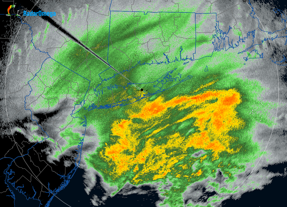
We had legitmate severe level winds in Maspeth, Queens on the Ridgewood Plateau. I had to call 911 to report sparking and smoking power lines the length of several blocks. I have footage I'll share likely tomorrow - it's Saturday night and the recording is extensive/requires editing/compressing - iphone 17 pro max. FDNY cordoned at least one intersection for a leaning powerline pole, down active lines. The powerlines were smoking for several minutes, electric stench as the outflow boundary raked through - green, purple, yellow sparks reaching the ground - not far from PS 229; at first I thought someone was shooting fireworks during a thunderstorm. It was the length of several blocks.
-
Longtime lurker. Usually lurking for reasons gratefully worded. The models don't care what anyone feels about them.
-
We also don't need temperatures in the 90s to achieve dews in the 70s. It can be in the 80s or 70s with just the same under tropical/WAR influence, which can run us into October. Subjectively, I like the variability with patterns vs. being locked in for weeks of dry/seasonable or hot/humid. Otherwise, there tends to be depreciation with many weather enthusiasts involving the same 'ol, whatever that may be - this ain't L.A. Averages are the measures of extremes, and there's value in that at our lat/lon.
- 1,764 replies
-
- 1
-

-
- hurricanes
- tropics
- (and 5 more)
-
2/13 Significant/Major Winter Storm Discussion & Observations
Shades replied to Northof78's topic in New York City Metro
I've watched ice cream cones melt slower on a sunny pavement within a week of the summer solstice. Could use some arctic air around, antecedent and precedent. My supervisor called me at 7am, telling me we're working remotely. By the time it was 9, I shoveled once "for kicks" of knowing what it feels like to move 1 and 1/2 inches of snow from the ground with a shovel. It was invigorating and I was hyped for the rest of the day to do it again after another 4" to 8", as much as the NWS forecasted. Working home remotely and going to lunch without having to lay out calcium chloride, that glare from the street and sidewalk though, hell of an albedo compared to snow. -
2/13 Significant/Major Winter Storm Discussion & Observations
Shades replied to Northof78's topic in New York City Metro
-
2/13 Significant/Major Winter Storm Discussion & Observations
Shades replied to Northof78's topic in New York City Metro
Close to 2" in Maspeth, north-central Queens; sleet from last night set a base layer for accumulation, roads are paste (not the common blacktop with temps in the low 30s) - despite hearing the salt trucks last night/this morning. -
There's much to more at stake when there are feelings involved. I always wondered about weather discussion boards implementing a "forecasting advisor" role, along with mods. Someone to bring those folks back down to earth. IJS
-
Thunder in Maspeth, Queens embedded in the band. Tropical downpour sans the tropical feel with temperatures in the 50s.
-
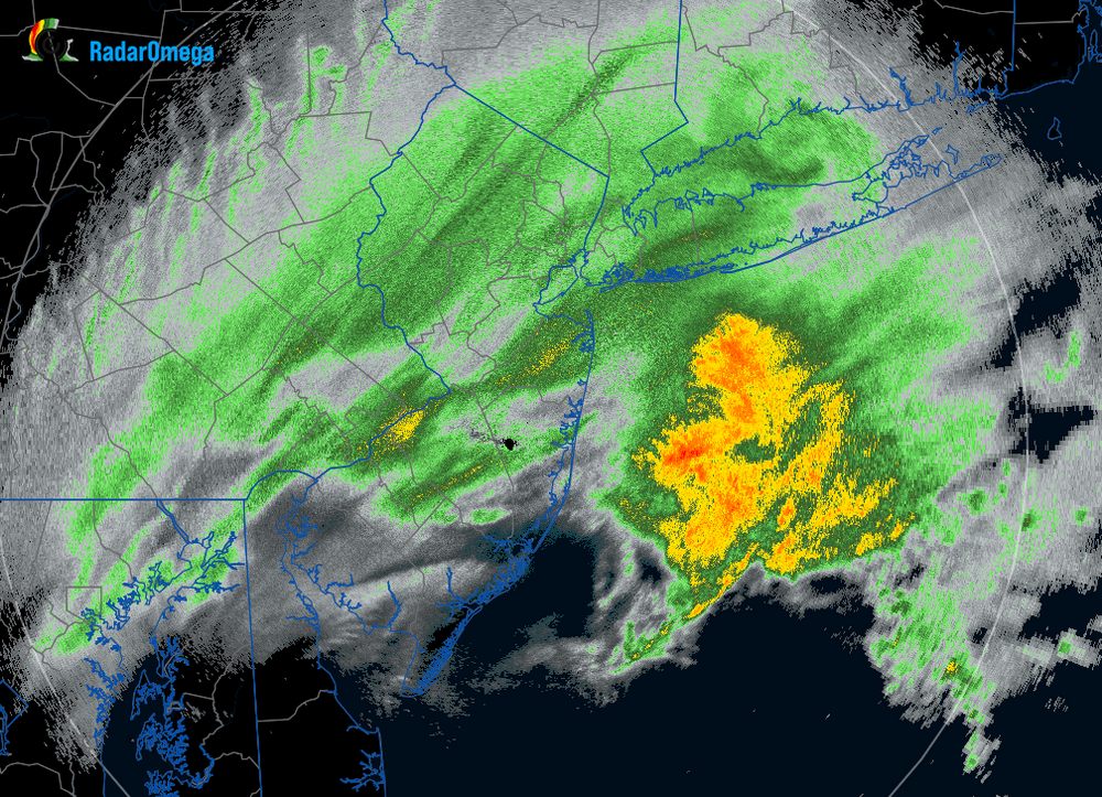
This was a classic setup for sea breeze and outflow boundaries from morning convective cells. The storms yesterday evening in central eastern LI were a precursor.
-
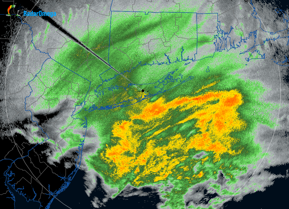
North central Queens where a severe thunderstorm warning initiated. No rain gauge, but as a previous owner of a Davis, the rain rate would have filled the catching cup.
-
Text: KLGA 010028Z 05015KT 10SM FEW080 SCT100 BKN250 21/15 A2989 RMK AO2 WSHFT 0011 T02110150 Temperature: 21.1°C ( 70°F) Dewpoint: 15.0°C ( 59°F) [RH = 68%] Pressure (altimeter): 29.89 inches Hg (1012.3 mb) Winds: from the NE (50 degrees) at 17 MPH (15 knots; 7.7 m/s) Visibility: 10 or more sm (16+ km) Ceiling: 25000 feet AGL Clouds: few clouds at 8000 feet AGL, scattered clouds at 10000 feet AGL, broken clouds at 25000 feet AGL Text: KLGA 312351Z VRB06KT 10SM FEW080 SCT100 BKN250 33/13 A2987 RMK AO2 SLP114 T03280133 10339 20311 55004 Temperature: 32.8°C ( 91°F) Dewpoint: 13.3°C ( 56°F) [RH = 31%] Pressure (altimeter): 29.87 inches Hg (1011.6 mb) [Sea level pressure: 1011.4 mb] Winds: variable direction winds at 7 MPH (6 knots; 3.1 m/s) Visibility: 10 or more sm (16+ km) Ceiling: 25000 feet AGL Clouds: few clouds at 8000 feet AGL, scattered clouds at 10000 feet AGL, broken clouds at 25000 feet AGL
-
LGA OBS 7:51 91F 8:28 70F