All Activity
- Past hour
-
Sign me up! April 96 is my favorite April of all time..
-
Obviously clown range BS, but please…NO. Next mid to late November…we’d all welcome it. Not on 4/7.
-
Records: Highs: EWR: 77 (1988) NYC: 76 (1988) LGA: 74 (2012) JFK: 66 (1987) Lows: EWR: 16 (1940) NYC: 12 (1888) LGA: 17 (1940) JFK: 22 (2014) Historical: 1765: A major snowstorm hit from Pennsylvania to Massachusetts. From Philadelphia, PA came this report: "On Sunday night last there came on here a very severe snowstorm, the wind blowing very high, which continued all the next day, when it is believed there fell the greatest quantity of snow that has been known for many years past; it being generally held to be two feet, or two feet and a half, on the level, and in some places deeper". (Ref. Wilson Wx. History) 1885: The minimum temperature for the date is 17°F in Washington, DC. (Ref. Washington Weather Records - KDCA) 1907: The maximum temperature for the date is 85°F in Washington, DC. (Ref. Washington Weather Records - KDCA) 1912 - Residents of Kansas City began to dig out from a storm produced 25 inches of snow in 24 hours. The snowfall total was nearly twice that of any other storm of modern record in Kansas City before or since that time. A record 40 inches of snow fell during the month of March that year, and the total for the winter season of 67 inches was also a record. By late February of that year Kansas City had received just six inches of snow. Olathe KS received 37 inches of snow in the snowstorm, establishing a single storm record for the state of Kansas. (23rd-24th) (The Kansas City Weather Almanac) (The Weather Channel) 1929: St. Louis, MO soared to 92°; their all-time record high for March. (Ref. Wilson Wx. History) 1934: Washington, DC had 3.7 inches of snow on 23rd and 24th. (Ref. Washington Weather Records - KDCA) 1957: Amarillo, TX picked up 11 inches of snow from an early spring storm. Drifts piled up to 14 feet in places. (Ref. Wilson Wx. History) 1959: The second major spring snowstorm in less than a week dumped 10 to 20 inches of snow across northeastern Colorado. 14.3 inches was reported in Denver where winds gusted over 35 mph creating near blizzard conditions with visibilities frequently down to ½ mile. (Ref. Wilson Wx. History) 1975: "The Governor's Tornado" hop-scotched a 13-mile path across the western part of Atlanta, GA during the early morning hours, causing considerable damage to the Governor's mansion. Hundreds of expensive homes, businesses and apartment complexes were damaged. Total losses were estimated at $56 million dollars. Three people lost their lives and another 152 were injured by the F3 tornado. (Ref. Wilson Wx. History) 1983: Late season snowstorm in the SE U.S. and parts of NC got 9 inches of snow on the 23rd and 24th. Click for Map of NC showing snow amounts Ref. Allen Huffman 1987 - A winter-like storm in the central U.S. produced blizzard conditions from South Dakota to western Kansas. Snowfall totals ranged up to 24 inches at Neligh NE, with 19 inches at Winner SD. Winds gusting to 60 mph created twelve foot snow drifts in Nebraska stranding thousands on the highways. (Storm Data) (The National Weather Summary) 1988 - Thunderstorms developing along a cold front produced severe weather from Minnesota to northeastern Texas. The thunderstorms spawned ten tornadoes, including one which injured five persons near Raymondville MO. (The National Weather Summary) (Storm Data) 1989 - Low pressure off the coast of Virginia brought heavy rain to the Middle Atlantic Coast States, and heavy snow to the Northern Appalachians. Cape Hatteras NC was soaked with 5.20 inches of rain in 24 hours, and snowfall totals in Vermont ranged up to 12 inches. Winds gusted to 52 mph at New York City. (Storm Data) (The National Weather Summary) 1990 - The storm system which produced heavy snow in the Lower Missouri Valley the previous day, spread heavy snow across parts of the Upper Ohio Valley and the Middle Atlantic Coast Region. Snowfall totals of 2.2 inches at Philadelphia PA and 2.4 inches at Atlantic City NJ were records for the date. Up to six inches of snow blanketed southern Ohio. In the Middle Atlantic Coast Region, snow coated the blossoms of cherry trees which had bloomed in 80 degree weather the previous week. (Storm Data) (The National Weather Summary) 1993: "The Winter of the Return of the Big Snows" continued to set records. Boston, MA had 8.6 inches of snow on this day to push its monthly total to 38.9 inches, which set a new March monthly snowfall record. (Ref. Wilson Wx. History)
-
Just say a quarter inch and be done.
-
Maybe .1" or .2" if I cared to measure, but nah. The 'flakes' were basically snow pellets..almost like cauliflower rice or those tiny styrofoam packing balls
-
Nah man I used my index finger to measure..Just trying to make sure it is up to the AMWX scientific standards..
-
38 / 22 cool but sunny today light years better than yesterday which should still wind up the coldest (day time) for the next 1-2 weeks if not well beyond that. Back and forth warmer Thu with the warmest spots to low 70s with enough sun followed by cooler Fri - Sun. Looks like a dry next 7 days till Wed/Thu next week . Overall warmer to at times much warmer Mar 30 - april 5th as it looks the sw / inland areas could see next round of 80s in the warmest case.
-
I'm sure hour 348 will verify
-
-
sorry but 39 and overcast with mist/drizzle is cold any time of the year
-
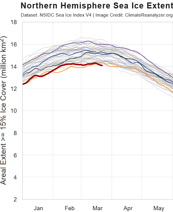
Yeah... B+ here seems right Slightly AN snowfall Cold for several months No rain until recently Constant snowcover since early December A few decent storms (one really good one)
-
Hopefully your ruler was calibrated correctly?
-
B+ prolonged cold and near continuous snow OTG and two decent 1'+ storms make this winter well above average in my book more frequent storms would have pushed it higher
-
It was snowing last night around 11pm. Not heavy but snow all the same
- Today
-
-
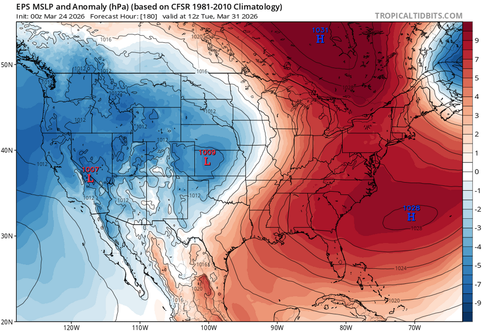
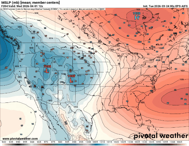
Early April looks like a battle between 80° warmth trying to push north vs the backdoor cold front. Notice the classic split high structure between Southeast Canada and Bermuda. My guess is that we will have a day or several that the 80° warmth pushes into NJ. But still uncertain how warm points north and east of NYC will be able to get.
-
Yes. Yesterday afternoon was in the 30s there.
-
Just about 1/2 inch in methuen!!..Hopefully the measurement is approved by AMWX's Department of Weights and Measures lol
-

2025-2026 Fall/Winter Mountain Thread
Maggie Valley Steve replied to Buckethead's topic in Southeastern States
37 this morning in the Valley. Definitely an inversion this morning. Looks like a shot of rain Friday afternoon/evening with the arrival of a Canadian front. A freeze looks likely Sunday morning across the Mountains. -
tony
-
another miss east meteors are so hot right now
-
Bartender drinking on the job
-
lol I was at a bar Thurs night, bartender says they are getting 4" of snow Sunday and 7" Monday. about 1/2" here
-
Hoping to get up next friday.
-
same here, but out in my way back yard there is still a foot of snow in some spots, but it is ripe. closing in on 4 months of snow on the ground (yes, it is not fully covered). went back for a bonfire on Saturday, stupidly drove the golf cart since I had a bunch of stuff to burn. Golf cart still back there stuck in the snow. womp womp.


