All Activity
- Past hour
-

Saturday, July 18, 2026 Thunderstorm/Severe Weather Potential
hudsonvalley21 replied to weatherwiz's topic in New England
Yup. Just extended that warning to the east/southeast -

Saturday, July 18, 2026 Thunderstorm/Severe Weather Potential
Damage In Tolland replied to weatherwiz's topic in New England
All heading for where the warm front passed. Far SW CT to NYC. Rest of region is screwed -
My new window track weep holes couldn’t keep up and overflowed during the heaviest
-
Last of the rain has moved through. Right around 1.5" for the day.
-
Go with the Badlands profile pic. It instantly worked for me lol.
-

Saturday, July 18, 2026 Thunderstorm/Severe Weather Potential
weatherwiz replied to weatherwiz's topic in New England
yup multiple warnings. -
Another flood watch where we watch others flooding.
-
My roof has already leaked in 2 places today. Thankfully very concentrated and not terrible. I’m going up on the roof tomorrow. I’m worried about that line in Jersey. I’m in West Babylon. Just get me to tomorrow
-
Just about a half inch here. I'm glad we didn't have widespread wind and tornado activity so far, and I hope it stays that way through tonight. No one needs that after the damage we already had around the 4th. Went to attend a birthday party just over the border in New Hope, PA. Heading down 287 got hit with some mega rates, people started pulling over. Also while there a few solid downpours came through, I imagine the totals down there had to be near 2 inches. Looked like a creek in the parking lot.
-
Getting the atmospheric ducting thing with low rumbling extended thunder now. Must be a bit of an inversion layer.
-

2026 Mid-Atlantic Severe Storm General Discussion
AlexD1990 replied to Kmlwx's topic in Mid Atlantic
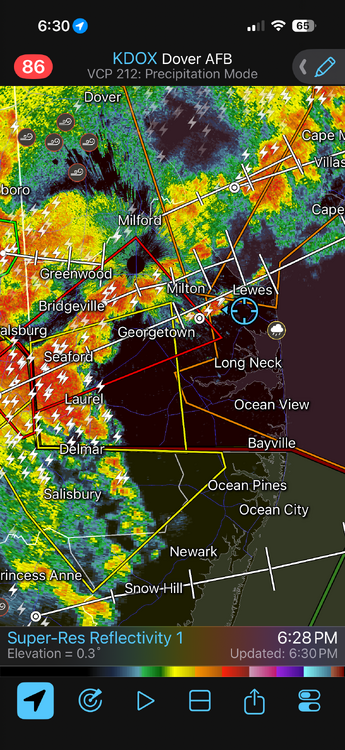
Right when the two storm complexes merged, tornado warning -
Saturday, July 18, 2026 Thunderstorm/Severe Weather Potential
hudsonvalley21 replied to weatherwiz's topic in New England
FYI That line east of KBGM has a tor warning. You had interest in that line earlier. Severe Weather Statement National Weather Service Binghamton NY 637 PM EDT Sat Jul 18 2026 NYC025-182300- /O.CON.KBGM.TO.W.0011.000000T0000Z-260718T2300Z/ Delaware NY- 637 PM EDT Sat Jul 18 2026 ...A TORNADO WARNING REMAINS IN EFFECT UNTIL 700 PM EDT FOR SOUTHWESTERN DELAWARE COUNTY... At 636 PM EDT, a severe thunderstorm capable of producing a tornado was located near Harvard, or near Walton, moving east at 40 mph. -
That part of DE always gets spinners, be safe!
-
Worst seems to be over now 1.60", time for a Steady Eddie
-

Saturday, July 18, 2026 Thunderstorm/Severe Weather Potential
VivaManchVegas replied to weatherwiz's topic in New England
got another 1/4" of rain today, so that was good. I don't think we are getting jack out of the next round. -
That is an exceptional amount of CAPE (nearly 6000) for a location on the East Coast. I am surprised there were not more svr hail reports. Low-level shear is weak. 0-6 km shear 37 kt so there is your supercell support. I think the storm coverage was a bit too much and that is what precluded more sig svr wx overall. A bit stronger capping probably would gone a long way.
-
Cell in Mercer is warned for Middlesex and southern somerset
-
-
Saturday, July 18, 2026 Thunderstorm/Severe Weather Potential
weatherwiz replied to weatherwiz's topic in New England
yes MCD was issued which includes western CT mentioning uncertainty in whether downstream watch will be issued -
Saturday, July 18, 2026 Thunderstorm/Severe Weather Potential
weatherwiz replied to weatherwiz's topic in New England
Expectations should always be low in our setups really. At least for me, part of the fun in all this is the "unknown". 99.999999% of the time (or some number that's essentially 100% without being 100%) severe weather here is not going to be widespread or even concentrated, its just going to be some reports scattered about and localized. But back to the fun...its the tracking and monitoring to see even if one storm produces...and if that one storm does produce, there is someone out there who was directly impacted. These setups are just so intriguing in that regard because the kinematics support the potential and generally instability is usually just enough to warrant some concern, but ultimately low enough to where maybe only a few storms will ever become mature enough to utilize the environment. -
Flash flood warning 1.54" and counting
-

E PA/NJ/DE Summer 2026 Obs/Discussion
MGorse replied to PhiEaglesfan712's topic in Philadelphia Region
A tornado warning now for portions of MD eastern shore and southern DE. -
Getting some additional rain here with continuous T&L
-
At the ducks game now. Hoping those storms fizzle or skirt south……
-
Yeah you are getting crushed again. Might end up with 5"+ over the last several days.