All Activity
- Past hour
-
Perfect position. Freeze the troff axis over indiana.
-

January 2026 Medium/Long Range Discussion
SnowFuturesTrading replied to snowfan's topic in Mid Atlantic
Run it. SInce Randy is on the train -
Yea I already have roof damming. May have to call someone soon to take care of it
-

Possible coastal storm centered on Feb 1 2026.
CCHurricane replied to Typhoon Tip's topic in New England
AI-GFS says game on for eastern areas... -
(002).thumb.png.6e3d9d46bca5fe41aab7a74871dd8af8.png)
E PA/NJ/DE Winter 2025-26 Obs/Discussion
ChescoWx replied to LVblizzard's topic in Philadelphia Region
12z GFS AI ticking back to coast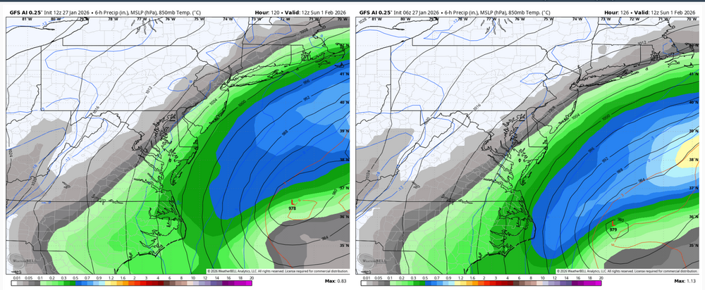
-
get a load of the GFS lol
-

Possible coastal storm centered on Feb 1 2026.
RUNNAWAYICEBERG replied to Typhoon Tip's topic in New England
Gfs AI is a tick nw with a glancing blow. I bet goofus does the same. -
84hrs vs last runs
-
Yep, we might be singing its praises later this week if the coastal storm development gets itself together so we’re not tracking this into NYC. The ridge axis here doesn’t scream way offshore track to me.
-

The “I bring the mojo” Jan 30-Feb 1 potential winter storm
StantonParkHoya replied to lilj4425's topic in Southeastern States
Skip would be losing his mind right now. RIP. -

Central PA Winter 25/26 Discussion and Obs
WmsptWx replied to MAG5035's topic in Upstate New York/Pennsylvania
If this thing trends west and becomes more than an idle threat, some TV folks are going to look bad. Tom Russell in particular. -

The “I bring the mojo” Jan 30-Feb 1 potential winter storm
MHCWEATHER replied to lilj4425's topic in Southeastern States
Moved from Raleigh to EI this summer. Kids are having winter FOMO (me too ), but I’m liking our chances. P.S. ‘89 Christmas Storm was epic in MHC P.P.S. RIP Skip Waters. My dude loved some snow. Miss his wish casting lol -
The “I bring the mojo” Jan 30-Feb 1 potential winter storm
StantonParkHoya replied to lilj4425's topic in Southeastern States
It was Christmas Night... -
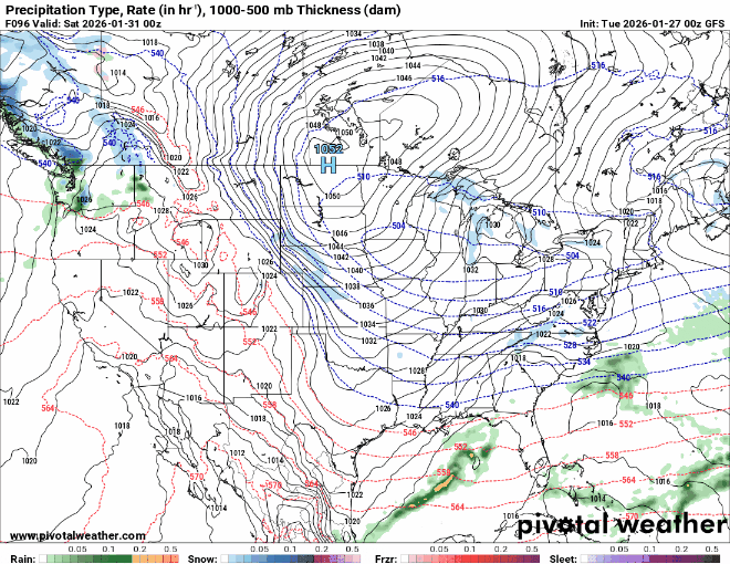
GFS has not wavered from this trend in 24 hours...
-

Possible coastal storm centered on Feb 1 2026.
HoarfrostHubb replied to Typhoon Tip's topic in New England
GFS looks to be digging for oil again -

The “I bring the mojo” Jan 30-Feb 1 potential winter storm
Orange county replied to lilj4425's topic in Southeastern States
I have constant arguements with my GF on this storm lol She lives in Garner -I was in Chapel Hill at the time and don't remember squat for a storm -

Possible coastal storm centered on Feb 1 2026.
George001 replied to Typhoon Tip's topic in New England
AI gfs is more amplified -
-
At 75h, the northern stream energy definitely looks a bit west of 06z. I have no idea how this changes things but its noticeable
-
AI GFS looks NW of 06 by a bit as well.
-

Possible coastal storm centered on Feb 1 2026.
jbenedet replied to Typhoon Tip's topic in New England
Could be better But.. I’m seeing the risk is much greater that it moves north from that depiction, given the current forecast progression of MJO and -NAO. -
ok guys, only one PBPer, who are we voitng for
-

January 2026 Medium/Long Range Discussion
Scarlet Pimpernel replied to snowfan's topic in Mid Atlantic
-
The Northern stream shortwave over the Canadian prairies acts as a kicker. It’s a lot slower on the GFS than the Euro or the ICON. That’s going to be a major issue if the faster/stronger idea is correct.
-
Close the doors. CLOSE the doors. Close the doors! (Only @stormtracker will know what I'm referring to, lol)