All Activity
- Past hour
-
It’s only temporary. I’m like the emergency back-up goalie this week.
-
Today's Highs BLM: 92 EWR: 92 New Brnswck: 91 ACY: 91 LGA: 91 TEB: 91 PHL: 91 TTN: 88 NYC: 87 JFK: 85 ISP: 85
-

Junorch obs and discussion 2026
CT Valley Snowman replied to Damage In Tolland's topic in New England
.06. Shaded areas stayed dry. -

Junorch obs and discussion 2026
Damage In Tolland replied to Damage In Tolland's topic in New England
People laugh but man I swear by this rule. Summer storm patterns reveal themselves early and overall hit the same area repeatedly all summer while Stein areas Stein repeatedly. I don’t know that there’s any real scientific reason to it, but as a general rule .. it’s just how it works -

Late May/June 2026 Medium/Long Range
JenkinsJinkies replied to JenkinsJinkies's topic in Mid Atlantic
It's rare in niñas, though it's been 30 years since the last time it happened in a niña. -
Yeah well where people actually live (the corridor) they do not and have not! All those 6-10" events (except for last year) have been by the water or something, lol
-
As far as I'm concerned, that storm didn't produce simply BECAUSE it was a nina. While there is statistically potential for 20"...the probability was not good. Why? Because NS...that's why. There will ALWAYS be something in the way, or developing too late. Happens way more in ninas than niños.
-
-
Let's see how long we're in the furnace.
-
I think that’s Earthlight?
-
Junorch obs and discussion 2026
Damage In Tolland replied to Damage In Tolland's topic in New England
After getting hit earlier today and over the weekend . At least there’ll be green grass at Treehouse for the holiday weekend.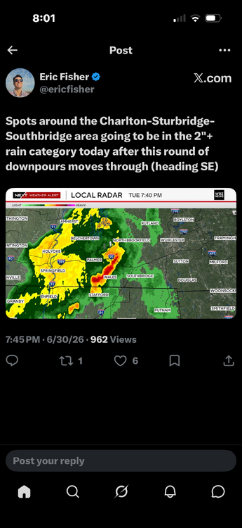
-
If I counted correctly, that was the 10th driest first half of the year in the DCA record, but you only have to go back to 2023 to beat it.
-
Wind switched, and temps have risen into the 80's here in town in the last couple hrs.
- Yesterday
-
Fill us in on who this is for those that are not on social media.
-
Junorch obs and discussion 2026
Damage In Tolland replied to Damage In Tolland's topic in New England
It may curve right like a dong . They typically do . -
Steiner here for the last 2mo.
-

2026-2027 Super El Nino
MarcmmKU replied to Stormchaserchuck1's topic in Weather Forecasting and Discussion
snowman made the stronger claim that +qbo, +enso decembers are a slam dunk always warmer than normal REGARDLESS OF STRENGTH (his exact words go read it). 1997/2004 are weakly +qbo. He's wrong. -
A friend of mine who works for PJM said Thursday is definitely going to break a record and that the western part of our region (Ohio, Michigan, metro-Chicago) are likely to place constraints on the rest of our region; but they are working to hopefully minimize whatever those constraints are.
-
 I understood the rules -- I just went too low.
 -
The overnight stuff looks to favor the northern part of New England.
-
.thumb.gif.f92b16c631a1d15d405ed77b33f0710d.gif) wow what a mistake!!
wow what a mistake!! -
The area power companies are going to be straining the next few days with the very high heat, humidity. 100+ temps for 3 days in a row. Hopefully we won't see any brown or black outs.
-
 What’s the word for Saturday? Looks good, maybe some scattered storms evening and night?
 -
Hey all... Newbie here. I live in the Northwest part of Philadelphia (Mt. Airy is the section of the city), am a Philly Public School teacher (Psychology and history) for 29 years, and have been a "lurker" on here for quite some time. I have learned a lot by reading the Philadelphia, NYC metro, and New England discussion forums over the years. I have been interested in the weather since I was a kid growing up in Wisconsin... I think the summer of 1977 with its heat and severe weather along with the winter of 1978-1979 (I was in 4th grade... we had so many snow days we had to make one up on a SATURDAY) are what sparked this interest. In any event, I look forward to perhaps joining in on some future discussions. Take care and stay cool this week.
-
Junorch obs and discussion 2026
Damage In Tolland replied to Damage In Tolland's topic in New England
Looks like about 15 minute shower . I’ll guess .06


