All Activity
- Past hour
-
I'm optimistic about Saturday, I think the storm will get the boot Friday evening and we'll have partly cloudy skies for the entire weekend with temps between 65-70.
-

2025-2026 ENSO
michsnowfreak replied to 40/70 Benchmark's topic in Weather Forecasting and Discussion
True. Hopefully the Pacific is more favorable. -

2025-2026 ENSO
40/70 Benchmark replied to 40/70 Benchmark's topic in Weather Forecasting and Discussion
Wait until we near solar min and swtich back to Pac cold phse in several more years.....get an apprciably strong Modoki El Nino and we'll do just fine. -
2025-2026 ENSO
40/70 Benchmark replied to 40/70 Benchmark's topic in Weather Forecasting and Discussion
It depends on the polar domain.........I don't think we will get a lot of help there, so we'd have to hope that the extra tropical Pacific continues to transition. You probably have more leeway than the east coast, but even you would want to see a -WPO take shape. -
 19/8/5
 -

2025-2026 ENSO
so_whats_happening replied to 40/70 Benchmark's topic in Weather Forecasting and Discussion
We would need to start seeing signs emerge if it was to tilt one way or the other more than just neutral. Nothing is catching my eye and overall as Bluewave has said it does look like things want to try to progress eastward in the tropics and switch things up a bit but the subsurface would not be super conducive to produce a weak or moderate El Nino right now if that were to actually start to show up. I think it is important to remember that La Nina is just a further enhanced state of what base state looks like as 40/70 has mentioned it is important on location of oceanic and even atmospheric features that dictate overall how things progress. We are pushing out from the spring barrier so we should start to see some signs emerge, what they are yet is anyone's guess. I gotta get to bed though I work tonight so ill be back on later. -
Doesn't look humid through D10 really. dewey may have some at-bats beyond that
-
2025-2026 ENSO
40/70 Benchmark replied to 40/70 Benchmark's topic in Weather Forecasting and Discussion
2015-2016 was the storngest El Nino on record and 2023-2024 was during a strong cold phase PDO....this is a silly statement. Now, if you want to tell me that 2023-2024 was so much warmer than 1972-1973, and 2015-2016 than 1997-1998 due to CC, okay....but don't compare two entirely different type of El Nino evolutions. Its a lazy, ill informed approach. -
Congratulations on your upcoming wedding.
-
Would love some warm and dry... alas... I fear humidity will be in play
-
That would be me, whoops, I just did...
-
Yeah EOM into June still looks warm/hot. Steined though
-
yep can't wait for the 240 hr Euro heatwave runs to be posted daily!
-
My guess is that the models don't account for surface friction and that most of the time, the mixing down gets "stuck" at the lowest levels? Winds are the hardest thing to predict. It used to be how much snow was going to fall from any one particular system. Of course, if you ask me, it has been unusually windy over the last 10 years or so?
-
2025-2026 ENSO
michsnowfreak replied to 40/70 Benchmark's topic in Weather Forecasting and Discussion
Interesting. I have heard some hedge towards cold neutral and some warm neutral. For me, either is fine because anything from weak nino to weak nina usually can produce good winters. But since its so early, Im wondering what, if anything, we can put off the table? I remember in years past some were so hellbent for months on a strong Nino or nina but when it actually happened it was weak. So far, it seems to be nearly unanimous that a strong ENSO one way or the other isnt happening. Or at least thats the way Im reading into it haha. But what are the odds a strong or moderate event catches everyone off guard? -
We had to purchase a portable unit for my mother-in-law's assisted living unit. Pretty nice and inexpensive device that seems to do the job where she is.
-
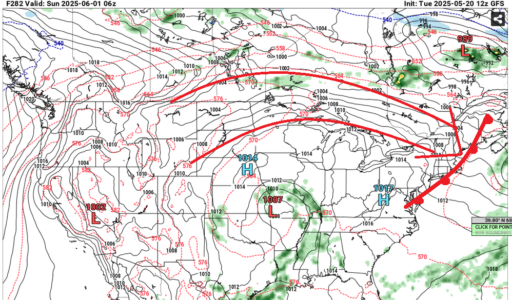
Kevin's over top warm blast is showing up on some of these recent GFS runs around June 1. This 12z version has a continental warm front demarcating a torpedo heat tube coming from the WNW ... probably 90 considering the sun up thickness is 567, and 572 by late afternoon behind this boundary... transporting 850s to 16+C in an easily tall mixing layer
-
2025-2026 ENSO
michsnowfreak replied to 40/70 Benchmark's topic in Weather Forecasting and Discussion

-
2025-2026 ENSO
so_whats_happening replied to 40/70 Benchmark's topic in Weather Forecasting and Discussion
We have seen this back and forth so much recently I am not confident this holds at all but for the mean time yes we are still having a La Nina atmosphere, even while weak to non existent SST profile, still holding the helm. Slow fade into Fall to neutral/warm status and maybe even a quick flare up of Nino like conditions atmospherically. No guarantee but the way things want to try and setup it seems this is possible. The biggest tell tale right now is the lack of WPAC typhoons should hit the record with no issue. Thoughts haven't changed in that aspect. There is no doubt though the warm pool has largely shifted now comes if it rebuilds in any meaningful way or we have another episode of end of summer/ fall push again. Yea I guess it will technically still register ENSO neutral but with a flare to Nino style is my current thought. We really may see the battle re establish again where we see a back and forth like last year. MJO is dead so it will be interesting if we follow a similar path as last year where a weak wave started moving again come end of June into July. -
West is best for Saturday.
-
2025-2026 ENSO
michsnowfreak replied to 40/70 Benchmark's topic in Weather Forecasting and Discussion
I dont disagree that its almost unheard of to get such a cold winter from such a strong Nino, but "if" we get a cold winter in the conus is such a ridiculous statement, unless you mead CONUS-WIDE. Obviously cold winters will happen. And to be honest, outside of the rarity that was the late 1970s, if you live in the east you would usually WANT the west to be warmer than avg. It would likely create a greater likelihood of some good storms. -
2025-2026 ENSO
michsnowfreak replied to 40/70 Benchmark's topic in Weather Forecasting and Discussion
You just dont stop. I know a met (used to post here, doesnt anymore like so many others) who worked for DTX from 1974-2010 and he always talked about the increasing UHI at DTW. You dont seem to understand that regardless of the surrounding area, when an airport expands and becomes a concrete jungle that it didnt used to be, it will affect particularly nighttime temps. Funny you didnt bring up Detroit City like you sometimes like to when it fits your theme. The avg min temp at DET is 1.0F warmer but at DTW it is 3.9F warmer for the two periods you unsurprisingly chose. But the max temp is identical at both- 2.4F warmer. Its been noted multiple times by people that actually live here and observer the weather how the lows at DTW were insane in the 1960s-70s compared to surrounding area. Although, as I recall, before you hijacked this thread and veered OT into your routine 1961-90 circle jerk, the conversation wasnt about temps, it was about snow (remember, you incorrectly said 1990s were "way" snowier). Why did you not include the snowfall for those same periods? I guess I will have to. No site changes or observation measurement changes at DTW or FNT (cant say for ARB). DTW snowfall 1961-1990: 41.5” 2001-2030: 45.8” FNT snowfall 1961-1990: 48.9” 2001-2030: 54.8” ARB snowfall 1961-1990: 42.3” 2001-2030: 60.8” -
sharing the road with these people
-
Well middle has cleared out & baking.
-
Saturday doesn't look like complete azz... dreary for sure Edit: 12z EC stil rolling, so that might change my views


.thumb.png.4150b06c63a21f61052e47a612bf1818.png)

