All Activity
- Past hour
-
does anyone have access to the aids euro
-
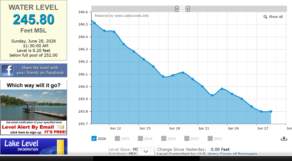
Definitely still a brutal GFS run through next weekend and perhaps even drier than the previous one. It is not doing anything with the lemon offshore. Falls Lake after yesterday's rainfall:
-

2026-2027 Super El Nino
mitchnick replied to Stormchaserchuck1's topic in Weather Forecasting and Discussion
Late to the party on this one, but this is the Cfs2 ssta map prog for December. Sure looks basinwide to these old eyes. Definitely not Modoki.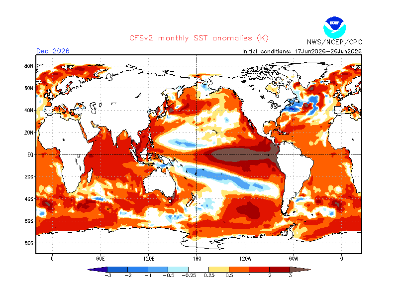
-
I am amazed at how wrong you can be about so many things!! No wonder you didn't know the difference between a Watch and a Warning! Amazing A couple other duds: Why would I be "vehemently against climate change" when it has been non-stop for millions of years! As far as "knowing more than studied meteorologists", that is hilarious!!! I like nothing more than learning from a true professional. Voretex 95 is highly intelligent and made fantastic contributions to the discussion yesterday. I only wish that he could find the time to make daily contributions. Cape? Well, he used to be contributory at times. More and more as he gets older, he gets his kicks by trying to be the bulldog on the block. Mental issues I guess. Stay straight, study hard and one day you may be a fine met. My disappointment yesterday was that several months ago, considering your desired course in life, I thought I could occasionally begin to learn from you. I just have to be patient.
-
To be fair, the 'white' region is 'equal chances' which pertains to either above or below normal. I think what trips people up is both the structure of the curves of those, plus the colorization. both inspire warm(cool) depending where the orientations layout. But, that product isn't scalar cold or hot. It's purely a probability. And the below area? that's not overwhelmingly high odds for below, either. So scoring this based purely on probability, that's not really a fail. It's certainly not good. But it's not an F
-
My COOP site (RSTM2) has never hit 100° either.
-
That's historic here in NJ. Ridge axis being a bit west could spare New England from 100s.
-
Just imagine the masterpiece of a symphony Beethoven could create based on the unison of hums from all of the A/C's that will be cranking full-throttle and non-stop for the next foreseeable future.
-
IMHO, one better have darn good reason and solid model agreement when forecasting all-time record events. esp. several days out. You don't just pick the most extreme scenario b/c that grabs the attention more to drive the hazard home. It is better to start more modest and work your way up as the fcst details become clearer. When you start at the top, it's very hard to come back down b/c of the viral nature of things on social media. And really, we know its going to very hot, so "piling on" tends be counterproductive (the apathy factor, and ppl get wise and say, "is it really that bad/dangerous b/c we've had 100+ before, and did just fine overall). This is not being snarky, the hype pushes things like one should not even go outside at all b/c it is so "dangerous" b/c it is 100 F. How did we ever survive as a society prior to this in-your-face danger hype or before AC, for that matter! The problem is the media doesn't act on a "linear scale." It's like if the temp hits 100, somehow that is *so* much worse or extreme than 99, when it is only b/c 100 is a power of 10 and a more psychologically satisfying value. That is meaningless as to sensible wx impact. Another example? A piece of crap low pressure gets named a TS, and it is like end of days to the media, when typical winter storms are *far* more impressive and powerful than a weak sheared TS.
-

Junorch obs and discussion 2026
Damage In Tolland replied to Damage In Tolland's topic in New England
-
Braun Bay might be 98.6 by Monday, and not because of urine either!
-
I know there is a risk, but right now I’d say 87-94 with a risk for shwrs/storms late day. I looked at everything and maybe there could be a risk the afternoon’s wettwr, but nothing stands out to me as a disappointment for the holiday right now.
-

E PA/NJ/DE Summer 2026 Obs/Discussion
MGorse replied to PhiEaglesfan712's topic in Philadelphia Region
Database issue causing widespread NWS web page problems. IT continues to work on it to get all restored. -
Inferno through Monday. What a holiday weekend. Wow.
-
E PA/NJ/DE Summer 2026 Obs/Discussion
MGorse replied to PhiEaglesfan712's topic in Philadelphia Region
0.23 inches of rain yesterday. -
I topped out at .66" for the event.
-

Junorch obs and discussion 2026
TauntonBlizzard2013 replied to Damage In Tolland's topic in New England
What’s your forecast for Saturday? -
Yes, the media thrives on sensationalism like oh my goodness , this has never happened before. And, millions of dunces believe it.
-
Gfs tries for ring of fire stuff but also tries to door east of ORH Wednesday. Still 85-90 in ern areas.
-
Another possible reason other than overzealous inexperience or pattern recognition denial? CYA - better safe than sorry. I find this a weak excuse these days. Forecast science and skill have come a *long* way in the last few decades alone, and we have models now that can show fine-details and fcst extreme events quite well now, so confidence level should be higher. There are less "surprises" now. We should be taking advantage of this better technology and skill that should result in *less* CYA - better safe than sorry. Over-warning I would argue is as bad as under-warning. Over-warning impacts tend to be more indirect, but still cost lives and lot of $$. "Damp street warning?" LOL. Sounds like something you'd see in Cali. Don't give them any ideas!
-
105+ across Europe past few days. Records getting shattered every month and yet many will still claim CC has nothing to do with it.
-
There is no way we'd get anything like that outside of a tropical storm direct hit.
-
Of note, some WFO CWAs have lowered the threshold of temps for issuing heat advisories and extreme heat watches/warnings. WFO BOX did this a number of years ago. Instead of 95-100 F, it was lowered to 90-95 F. I don't know about other CWAs, but it something to be aware of as our standards and practices change over time, and the trend is lowering the bar for more watches/warnings. And the media takes full advantage of this, acting like changes in wx have demanded this, when it is social/political/economic factors, among other things. We will soon have PDS blizzard and ice storm warnings, and you can bet the media will say, "FOR THE FIRST TIME EVER the NWS has issued a PDS..."
-
Lots of kids in camp during the day. Mine included
-
.3" yesterday. Over 4" mtd. NEMD pummeled I suppose.


