All Activity
- Past hour
-

Feb 10-11 Mid Week Minor Event - Ride the hot hand?
Ginx snewx replied to HoarfrostHubb's topic in New England
Radar across the east looking south of global models -

Feb 10-11 Mid Week Minor Event - Ride the hot hand?
CoastalWx replied to HoarfrostHubb's topic in New England
Sorry, I meant what it has for advisories. they should at least have north of the pike. -

Feb 10-11 Mid Week Minor Event - Ride the hot hand?
moneypitmike replied to HoarfrostHubb's topic in New England
I think GYX is being way too aggressive here. P/C is for 3-7. -
Feb 10-11 Mid Week Minor Event - Ride the hot hand?
Ginx snewx replied to HoarfrostHubb's topic in New England
Tell us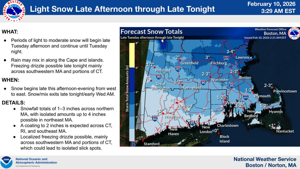
-

Winter 2025-26 Medium/Long Range Discussion
Baum replied to michsnowfreak's topic in Lakes/Ohio Valley
Stick a fork in it. -

Feb 10-11 Mid Week Minor Event - Ride the hot hand?
HoarfrostHubb replied to HoarfrostHubb's topic in New England
Snowing now. A coating to 0.25” -
Feb 10-11 Mid Week Minor Event - Ride the hot hand?
CoastalWx replied to HoarfrostHubb's topic in New England
BOX map is bizarre. Anyways hoping 2-4 here. -
Watching models this season is like watching Angel Hernandez ump an MLB game
-

Winter 2025-26 Medium/Long Range Discussion
A-L-E-K replied to michsnowfreak's topic in Lakes/Ohio Valley
Winter about done? -
Yeah the Ukie is.
-
.thumb.jpg.6a4895b2a43f87359e4e7d04a6fa0d14.jpg)
Central PA Winter 25/26 Discussion and Obs
Yardstickgozinya replied to MAG5035's topic in Upstate New York/Pennsylvania
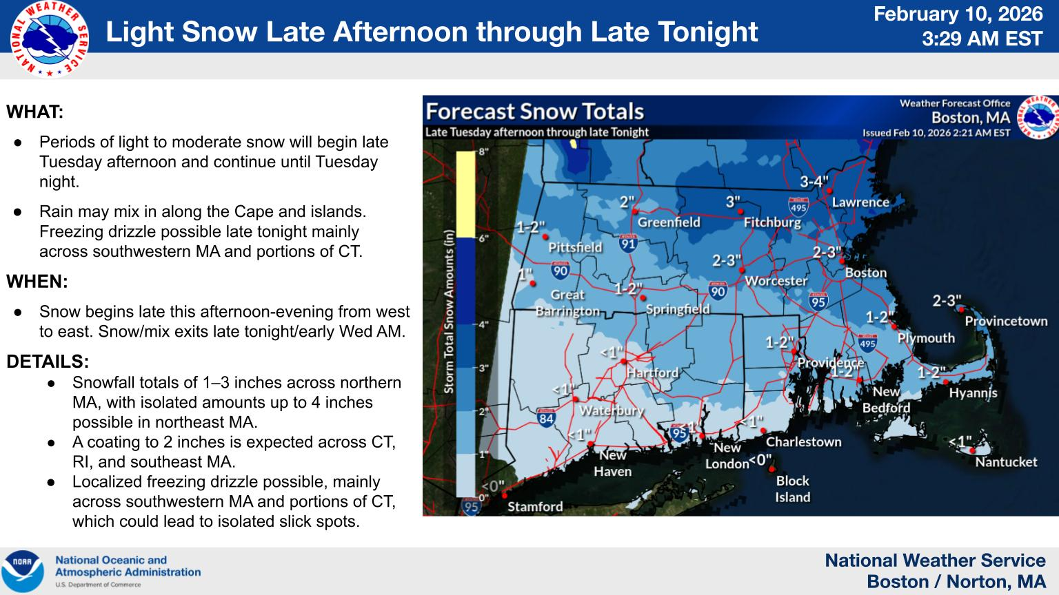
The good news is NWS has Increased their confidence in a winter storm during Sun-Mon timeframe. The bad news is NWS has lowered confidence in the occurrence of precipitation Sun-Mon. Once again they're getting all the angles covered. Area Forecast Discussion National Weather Service State College PA 444 AM EST Tue Feb 10 2026 .WHAT HAS CHANGED... * Increased confidence in winter storm during Sun-Mon timeframe * Holding off on any winter weather advisories for possible ice accums for E/NE this evening-SW later tonight && .KEY MESSAGES... 1) Light precip possible later today and this evening, with light post-frontal snow showers and gusty winds over the Alleghenies later tonight through Wednesday night. 2) Lowered confidence in occurrence of precipitation Sun-Mon. Confidence in timing of possible precip is slightly higher. Confidence in precip types/amounts remain low -
It’s always fascinating to track how active weather patterns evolve from month to month and how different systems interact across regions. April can bring a wide range of conditions, so sharing observations helps us all understand broader trends better. Do you usually notice a shift in storm behavior this time of year where you’re located, and do travel plans around weather ever affect your rides with services like sallimoservice?
-
 The euro really caved to the euro ai it seems. Good to know! But yeah this period is just too warm.
 -
Good bye and good luck.
- Today
-
Central PA Winter 25/26 Discussion and Obs
Yardstickgozinya replied to MAG5035's topic in Upstate New York/Pennsylvania
Well, I'll be d***** . Looks like that might be able to sneak in here.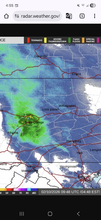
-
 Remember last week when I said you all are tracking a rainstorm and I was accused of negativity and whining and now 5 days of models runs later and you admit that I am in fact....... Correct.
 -
Isnt he allowed to twerk on a pole without you objectifying him??!?!?!
-
Inside on a computer in air conditioning? Lol
-

Feb 10-11 Mid Week Minor Event - Ride the hot hand?
wxsniss replied to HoarfrostHubb's topic in New England
6z NAM / RGEM solid 2-4 / 3-6 east RGEM has been pretty good this winter and relatively steady for Tuesday -

2026-2027 El Nino
Stormchaserchuck1 replied to Stormchaserchuck1's topic in Weather Forecasting and Discussion
This is a time sensitive ENSO subsurface anomaly map, and 5-day subsurface temperature trend. It will always be updated to the most recent day. -
2025-2026 ENSO
Stormchaserchuck1 replied to 40/70 Benchmark's topic in Weather Forecasting and Discussion
I made a new thread This one should still continue through the Winter, as effects of yearly ENSO state are felt through the following March. -
The subsurface has warmed significantly over the past few months. That's +4c in the central-ENSO-subsurface. TAO/Triton is a little more conservative in their readings than CPC, and it still has a >+4c area in the western subsurface I went through, since data became available in 1985, and found the 10 top analogs to broad subsurface state in January-February, like we have now. There are 5 positive analogs, 5 negative analogs. It should be noted that a lot of analogs had a warm/cold western part vs a cold/warm eastern part, in contrast, and I didn't use those, I only did the whole subsurface based warm or cold. Jan-Feb 2026 so far -1) 2025 -- This later in the year was ENSO Neutral (0-1-0), with the ONI peaking at -0.5c, but not for 5 consecutive months. The RONI in 26-27 was Weak-La Nina, -1.0c +1) 2023 -- This later was a Strong El Nino (1-1-0), ONI peaking at +2.1c, RONI peaking at +1.5c +2) 2015 -- This later was a Strong El Nino (2-1-0), ONI peaking at +2.8c! RONI peaking at +2.4c +3) 2014 -- This later was a Weak El Nino (3-1-0), ONI peaking at +0.8c, RONI peaking at +0.6c -2) 2007 -- This later was a Strong La Nina (4-1-0), ONI peaking at -1.6c. RONI peaking at -1.6c +4) 2002 -- This later was a Moderate El Nino (5-1-0), ONI peaking at +1.3c. RONI peaking at +1.5c -3) 1999 -- This later was a Strong La Nina (6-1-0), ONI peaking at -1.7c. RONI peaking at -1.7c +5) 1998 -- This later was a Strong El Nino (7-1-0), ONI peaking at +2.4c. RONI peaking at +2.4c -4) 1994 -- This later was a Moderate El Nino (7-1-1), ONI peaking at +1.1c. RONI peaking at +1.4c -5) 1988 -- This later was a Strong La Nina (8-1-1), ONI peaking at -1.8c. RONI peaking at -1.9c So out of the hand-picked 10 best analogs of the past 40 years, 8/10 (80%) became the same ENSO state (warm subsurface to El Nino, cold subsurface to La Nina), 1/10 (10%) was Neutral the next year, and 1/10 (10%) was opposite. The total cumulative ONI peak for the 10 top analogs since 1985, was +13.9c, an average of +1.39c per year (Moderate ENSO state). CPC in January gave these probabilities I now see the RONI is linked on the CPC page. Very good! (Edited analogs above -- the RONI is good because it neutralizes the global warming skew, where ENSO has warmed on average about 0.2-0.3c vs historical) Climate Prediction Center - Relative Oceanic Niño Index (RONI) Mid January IRI models forecast. I will edit these if someone links more recent forecasts. Since 1994, only 7/31 ENSO years have been Neutral, per RONI. 24/31 have either been La Nina or El Nino. Since 1994, only 7/31 ENSO years have been Neutral, per ONI. 24/31 have either been La Nina or El Nino. Per RONI, 5 of the last 6 years (20-26) have been La Nina. Per RONI, 7 of the last 10 years (16-26) have been La Nina. Per RONI, 11 of the last 19 years (07-26) have been La Nina. Per RONI, 15 of the last 28 years (98-26) have been La Nina. That's >50% La Nina since 1998. You can see this post-1998 general La Nina pattern clearly in the Northern and Southern Hemisphere's Hadley Cell, High pressure right above and below Nino 3.4: ^People say it's a decadal PDO state, I think it's a decadal cold-ENSO state. That map encompasses the most recent 333 months.
- 1 reply
-
- 1
-

-
2025-2026 ENSO
Stormchaserchuck1 replied to 40/70 Benchmark's topic in Weather Forecasting and Discussion
Subsurface is torching. Should I start an El Nino thread for 26-27? -
 This thread has gone completely to hell and back folks. We could at least track severe weather.
 -
You'll be relieved to learn that one person (at least) understood the point you were making -- the most extreme portion of winter is now past, like on August 10th the most extreme part of summer is done. But nearly similar records can still be hit. (he wasn't trying to say the sun angle on Feb 10th = sun abgle on Aug 10th).