All Activity
- Past hour
-
Those Tempest stations are impressive units - and not requiring power and no moving parts is a big bonus. I've debating getting one but don't really know where I'd put it so it's not just baking in full sun all the time.
-

July 2025 Obs/Disco ... possible historic month for heat
Torch Tiger replied to Typhoon Tip's topic in New England
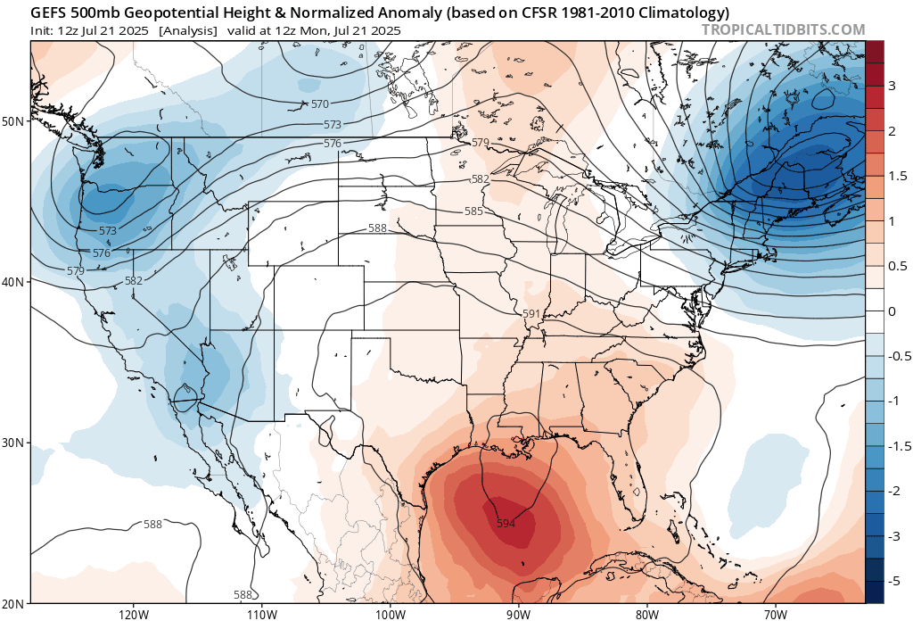
that pesky polar blocking really setting up on that run -

2025 Atlantic Hurricane Season
TheBudMan replied to BarryStantonGBP's topic in Tropical Headquarters
this is why the block feature is there. Used it on Curly boy last year and this forum improved immediately. Now its Barrys turn
-

July 2025 Obs/Disco ... possible historic month for heat
HoarfrostHubb replied to Typhoon Tip's topic in New England
I didn’t think I would have any more 90s this month. But Friday could definitely do it. -

July 2025 Obs/Disco ... possible historic month for heat
ineedsnow replied to Typhoon Tip's topic in New England
Awesome! -

July 2025 Obs/Disco ... possible historic month for heat
powderfreak replied to Typhoon Tip's topic in New England
Bottle it up.
-

July 2025 Obs/Disco ... possible historic month for heat
weatherwiz replied to Typhoon Tip's topic in New England
I would expect that this deep into summer the EPO and especially the PNA would have minimal, if any, influence on the pattern at all. the other thing I think to keep in mind too (and this fits in with your bolded) is with this pattern upcoming, it is likely to be quite convectively active across the International border with potential for numerous MCSs and squall lines. Given we're downstream of this, the impacts (or how the models think downstream will behave) are going to be more pronounced over our region. I mean at some point we are going to start to see noticeable changes occur as we continue approaching the equinox, but we are a good 4 weeks or so before we start to see these changes take place. -

July 2025 Obs/Disco ... possible historic month for heat
kdxken replied to Typhoon Tip's topic in New England
I'm seeing if it's safe to go outside? -
Of course, you're getting those saying a weak La Nina is going to develop going into the Winter, but I suspect even if that happens, it won't really make much of difference ( like a typical La Nina ). Thanks for your blog/insight on what you are seeing for this upcoming Winter.
-

July 2025 Obs/Disco ... possible historic month for heat
Typhoon Tip replied to Typhoon Tip's topic in New England
There's blocking at higher latitudes over the western Aleutian arch and also up over the western Beaufort Sea, but that's far away. It is unclear in summer wave scaling if that would be much of an exertion on the circulation mode over eastern N/A's mid latitudes ... Meanwhile, the NAO is rising positive - though telecon correlation in summer gets rather vague. Right now the EPO and PNA are flatlining neutral, making any signal utterly not there either way. I sense these operational runs - which are exhibiting typical summer bad continuity out in time - are about as useful as shitty toilet paper. Just go back two runs in the GFS and it's different hemisphere. As we've noted many times in the past ... these deep vortices/SPV's in the late mid ranges tend to de-amplify in time. True in winter or summer. I don't know, it seems to me we've been down this end summer in the middle of summer routine before, and routinely these haven't occurred. The onus is on one of those to actually verify. -
For an individual location like NYC, 34.8° for DJF was the 37th warmest winter average temperatures using dense rank sorting for temperature. The CONUS averaged 34.07° and 27th warmest. In this case NYC was representative of the country for the winter of 2024-2025. So your statement about the national average having nothing to do with individual locations is incorrect.
-

2025-2026 ENSO
michsnowfreak replied to 40/70 Benchmark's topic in Weather Forecasting and Discussion
Yes. And thats happened multiple times in recent years- below zero temps with strong winds. -
That is the main problem with a lot of these stations that are affordable. They are an all-in-one. I was able to get my station on to my roof which is at the acceptable height for winds (and on a pole so that the house doesn't block it), but then the temps are messed up. I figured it was easier to get a smaller station for more accurate temps vs getting something only for winds. Who knows. Looks good though!
-
Yeah. I said that last winter. Some of the air masses last winter were very cold. We had a couple of mornings here that were below zero with strong winds. It takes a very cold airmass to achieve that around here with the warming influence of the Great Lakes. Below zero temps are much more common here in clear, calm nights. If we would have had any clear and calm nights when those air masses were overhead, there would have easily been some -20s in some spots. The center of those Arctic highs were generally south of here so the atmosphere always stayed well mixed
-
Super cool to see the cold front moving south on radar with the north blowing wind behind it.
-
.thumb.png.4150b06c63a21f61052e47a612bf1818.png)
July 2025 Obs/Disco ... possible historic month for heat
HIPPYVALLEY replied to Typhoon Tip's topic in New England
Looks fairly dry moving forward. This part of the State could use some rain for sure. -

July 2025 Obs/Disco ... possible historic month for heat
Go Kart Mozart replied to Typhoon Tip's topic in New England
lol, yes you are correct! -
July 2025 Obs/Disco ... possible historic month for heat
Go Kart Mozart replied to Typhoon Tip's topic in New England
It's over, Johnny. -
July 2025 Obs/Disco ... possible historic month for heat
Go Kart Mozart replied to Typhoon Tip's topic in New England
AI has been rock solid. Are you still using physics-based models? - Today
-

July 2025 Obs/Disco ... possible historic month for heat
dendrite replied to Typhoon Tip's topic in New England
Scary cold in the extended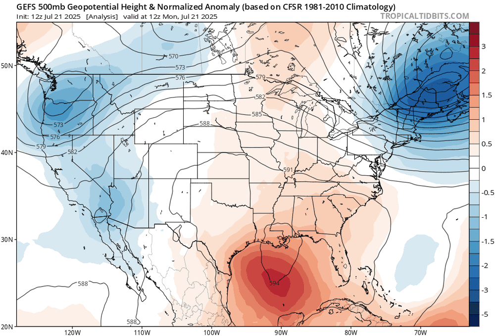
-

July 2025 Obs/Disco ... possible historic month for heat
dryslot replied to Typhoon Tip's topic in New England
30's tonight for some low lying valleys? SLK? -
July 2025 Obs/Disco ... possible historic month for heat
ineedsnow replied to Typhoon Tip's topic in New England
Looks like we may pull 90 plus here on Friday.. Hopefully it's the last -
2025-2026 ENSO
michsnowfreak replied to 40/70 Benchmark's topic in Weather Forecasting and Discussion
Also, remember bluewave keeps talking about the nation as a while. Which is fine. But has nothing to do with temp departures at individual locations. The SW was much warmer than avg. It was very cut and dried here, Dec was warmer than avg, Jan & Feb were colder than avg. And this is true even when using the entire POR averages. Wasnt record cold by any means, but it was steady cold much of the time. The winter as a whole was very "mid" with no months anywhere near record warm or cold. DETROIT Dec- 33rd WARMEST of 152 Jan- 52nd COLDEST of 152 Feb- 69th COLDEST of 152 NEW YORK CITY Dec- 59th WARMEST of 156 Jan- 65th COLDEST of 156 Feb- 54th WARMEST of 156 -
Looks pretty solid .
-
July 2025 Obs/Disco ... possible historic month for heat
dendrite replied to Typhoon Tip's topic in New England
70.8F may do it for the day.