All Activity
- Past hour
-
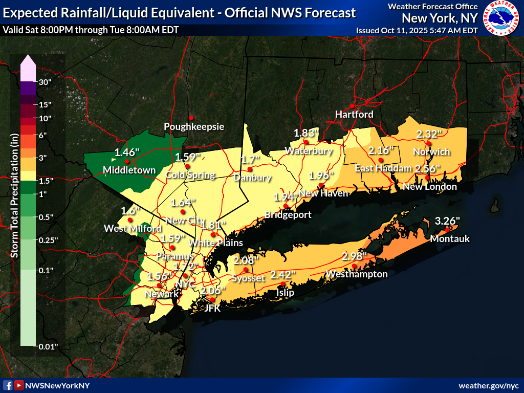
 That Ocean / Monmouth County area has been targeted for several runs on various models for the heaviest rains. Overall this map does not look out of line and is about what I'm expecting. Maybe boost the totals some for LI? Strong onshore winds always were going to be the main feature of this event along with associated moderate to perhaps major coastal flooding especially NJ coast / bays. Solid beach erosion is going to take place over 3 three high tide cycles. I think inland winds are overdone but would not be shocked to see some gusts to 60 mph+? along the NJ coast. Expecting up to 30 mph up in my neck of the woods.
 -
 Wild per hourly forecasts gusts start about 11 am Sunday and end about 11 pm Monday. Not often to have that long of a winds even 35+mph gusts.. Tuesday shows gusts in the 30s too so I'll add that onto such a long wind event.
 -
I meant to hit the 9 not 8. Thanx.
-

"Potentially" powerful Nor'easter Sun-Mon 10/12-13/25 with needed rain-especially south of I84, and fairly high impact sct coastal gusts 50+ MPH and possibly moderate or greater coastal flooding at the midday Sun and Monday high tide cycles.
Stormlover74 replied to wdrag's topic in New York City Metro
Yeah crazy the back and forth- 247 replies
-
- 1
-

-
- heavy rain
- damaging wind
- (and 2 more)
-
This reminds me of an old Donald Duck comic where he won the lottery but to be able to claim it he had to walk into the lottery offices walking backwards, hopping on his left leg while saying good morning in Chinese lol It was something like that. All technical crap designed to prevent him from claiming his winnings. The government works in a similar fashion haha
-

The return of the elusive Nor'easter. Drought buster or bust?
nj2va replied to dailylurker's topic in Mid Atlantic
Don’t worry 20:1 ratios will save us -
Some scattered showers out there moving through the area.
-
So despite any cataclysmic damage done by the weather, you can't get any federal funds unless you call a state of emergency? And if you do call a state of emergency with little or no damage you get federal funding?
-
From 9/1/24. My total is 34.41", that's when drought really started... Aug though was quite wet here with over 6" of rain .
-

The return of the elusive Nor'easter. Drought buster or bust?
CAPE replied to dailylurker's topic in Mid Atlantic
We like to see it, but rooting for it won't make it happen. The general flow in a Nina with overall lack of an extended southern jet make it a pretty difficult outcome. -

"Potentially" powerful Nor'easter Sun-Mon 10/12-13/25 with needed rain-especially south of I84, and fairly high impact sct coastal gusts 50+ MPH and possibly moderate or greater coastal flooding at the midday Sun and Monday high tide cycles.
weathermedic replied to wdrag's topic in New York City Metro
NWS briefing seems to cover everything quite well LatestBriefing.pdf -
 Upton's AFD notes models struggling with which southern vort turns into the storm-that's why we are seeing the back and forth here
- 247 replies
-
- 2
-
-

-
- heavy rain
- damaging wind
- (and 2 more)
-
What were you expecting on the urban valley floor? Nah but seriously, you moved back up here just in time for the new 80s to start.
-
Save a horse, ride the wobbly waffling Euro
-

Spooky Season (October Disco Thread)
H2Otown_WX replied to Prismshine Productions's topic in New England
Tippy said NoP first snow threat is looming after 10/22. -
If you stretch that back to 8/1/24 what's the total precip?
-
Models are still all over the place on this one. Seems like the multiple low scenario is really throwing a wrench into consensus. If we avoid the dual low setup should be a windier/wetter setup for most. Otherwise that second low farther off shore robs a lot of the energy to the east and also brings more dry air into the mix. Maybe we will have more data by 12z/18z to see which setup will win out.
-

Spooky Season (October Disco Thread)
moneypitmike replied to Prismshine Productions's topic in New England

- Today
-
 Follow NWS warnings and statements. Probably a good idea to plan altnerate travel plans Sunday afternoon-Monday night. Air travel will be impact as well roads. Deeper bands of heavier gusty rains Sunday night-Monday morning then low top steady light-briefly mdt rain Mon afternoon-night. I could be in error on my take but what am prepared for in the NYC subforum. Am not exactly sure what is out by NWS. I think they have the CFWRNG's out, if not...going to happen, probably 3 cycles of MDT, possibly a major in there Monday-also dependent on the sub basins, especially packing in on the northeast wind. Follow NWS. Coastal flooding also will have a river runoff component at the interface between incoming ocean waves, wind, elevated water level and dealing with 1-3" of rainfall runoff attempt into the ocean-marshes etc. My guess is that the HWA will convert to warnings on the coasts, for sct G50-60MPH, with the warning approach from my view, exacerbated by wet coastal ground, uproots and fully leaved wet leaves breaking branches Sunday evening-Monday. Could see few g45 MPH western NJ/se NYS and CT as well Sun night-Monday morning. Isolated inland flood warning in NJ (Ocean-Monmouth) Monday morning???? if some of the outlier model 4-6" materializes. Rainfall dependent. Modeling and WPC has consistently highlighted Ocean and Monmouth counties for biggest rainfall past few days. WPC trimmed qpf slightly in its early morning forecast. I'm expecting a little more than what they have, similar to early yesterday's 10z/10 forecast. Back later in the day. Will convert headline this afternoon to add OBS, but do add OBS rainfall from today when it occurs.
- 247 replies
-
- 3
-

-
-
- heavy rain
- damaging wind
- (and 2 more)
-

2025 Atlantic Hurricane Season
NorthHillsWx replied to BarryStantonGBP's topic in Tropical Headquarters
Another lemon in the MDR -

The return of the elusive Nor'easter. Drought buster or bust?
Eskimo Joe replied to dailylurker's topic in Mid Atlantic
This is why you always want to root for the northern stream to dive south of us. We get the warm air adcection precip, the transfer, and the upper level cold conveyor belt on the back side. It's the easiest and most reliable way to win.