All Activity
- Past hour
-
Insane... imagine if the curve N never takes place and a WNW track continues. Get your sharpie out. It would change model reliance forever. Kinetic Energy FTW.
-
Lol, in my experience it's usually the other way around.
-

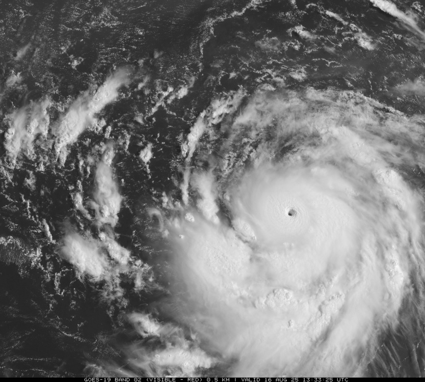
Hurricane Erin - 145 mph - 935mb - WNW @ 20
hawkeye_wx replied to BarryStantonGBP's topic in Tropical Headquarters
Now 922 mb extrap, 156 kts flight level wind. The inner core remains extremely tight, with no sign of any outer wind max beginning to develop. -
 Theres a whole forum for that. Thats a great place to discuss 30 year averages all over the place, not just here. You could link those discussions here anytime. Too many posts here about a warm day or a string of warm days this year are the fault of man made global warming especially this year, when we have 1 really above normal month since December. It’s just thin gruel in the context of the weather. global climate writ large, thats the right place because this is a hot year on a global scale. It’s just not that hot here this year in extremis over the last 40. So lets keep it to weather.
 -

Hurricane Erin - 145 mph - 935mb - WNW @ 20
NorthHillsWx replied to BarryStantonGBP's topic in Tropical Headquarters
FL was just shy of 150kts and with SFMR more than supportive of a 5 in both SW and NE eyewalls I personally think there’s enough for an upgrade. Min pressure tanking through the 920s also firmly supports it -
Problem is some of the same large scale forcing that causes cold now can cause an opposite reaction mid winter. That’s why snowfall in October has no correlation with a snowy winter.
-
 The GFS after 4 run cycles lost the tropical storm it had going into the Fl/Southeast in the 8/26 - 8/29 timeframe.
 -
Very photogenic fishfood...
-
Hurricane Erin - 145 mph - 935mb - WNW @ 20
NorthHillsWx replied to BarryStantonGBP's topic in Tropical Headquarters
That was a well-timed pass for the ages -
79 / 69 clearing a bit here.
-
Erin went from tropical storm to Cat 4 hurricane in 24 hours !
-
 No such thing as current weather in the obs thread, you should know this by now. 5 people control this thread and 1 awful met that said Erin was going into the Gulf.
 -
You say warm up, to what? '80s for a couple days or an extended stretch?
-

Hurricane Erin - 145 mph - 935mb - WNW @ 20
BooneWX replied to BarryStantonGBP's topic in Tropical Headquarters
Wow . -
Two days ago ... both the numerical teleconnectors, and the spatial-synoptic evolution, from all three ens means, looked "shot across the bow"-esque with the post August 20 range... As Scott also mentioned, there's a signal now to confined that more to just the third-ish week. The last week of the month reverses. I remember commenting a month ago, that I didn't like the August cool idea being floated at the time - memed to death by the usual X suspects - because there has been this leitmotif to lower Pacific NW heights. We may still end the month more marginal-AN. It'll be close. Regardless, whenever the models this season have showed more ridging in Pac NW outlooks, it was proven unstable. Within short days ... new height crash and troughs were digging down the B.C. coast. So long as that return base-state behavior is there, that's a non-linear indicator where the forcing the hemisphere wants to really be - it's your "correction vector". Here we are again... We'll see, but as of this moment starting to characterize as a mere pattern reset.
-

Hurricane Erin - 145 mph - 935mb - WNW @ 20
GaWx replied to BarryStantonGBP's topic in Tropical Headquarters
Due to Erin ACE is now rapidly rising with 2025 about to cross median (of last 75) and should cross mean tomorrow. 2025 could reach top 20 by Mon and top 15 by Tue or Wed. -
I would be surprised if this did not make a cat 5 intensity.
-
Records: Highs: EWR: 99 (1944) NYC: 95 (2015) LGA: 94 (1944) JFK: 94 (1978) Lows: EWR: 57 (1945) NYC: 56 (1979) LGA: 58 (1979) JFK: 56 (1979) Historical: 1777 - The Battle of Bennington, delayed a day by rain, was fought. The rain delayed British reinforcements, and allowed the Vermont Militia to arrive in time, enabling the Americans to win a victory by defeating two enemy forces, one at a time. (David Ludlum) 1909 - A dry spell began in San Bernardino County of southern California that lasted until the 6th of May in 1912, a stretch of 994 days! Another dry spell, lasting 767 days, then began in October of 1912. (The Weather Channel) 1916 - Altapass, NC, was deluged with 22.22 inches of rain in 24 hours to establish a state record. (The Weather Channel) 1946: St. Louis, MO set its 24 hour rainfall record with a deluge of 8.78 inches on this date through the 16th. (Ref. AccWeather Weather History) 1969: During the early evening, an Air Force Reconnaissance plane investigating Hurricane Camille in the Gulf of Mexico found an unbelievably low central pressure of 905 millibars or 26.72 inches of mercury. This information allowed forecasters to warn residents along the coast that Camille would cause damage of unprecedented proportions. (Ref. AccWeather Weather History) 1974: De Pere, WI -- Lightning struck and killed a youth as he was driving a tractor on a family farm three miles west of De Pere. (Ref. Lightning-The Underrated Killer.pdf) 1978: One foot of snow fell at Yellowstone National Park in northwestern Wyoming. (Ref. AccWeather Weather History) 1980: DCA, first minimum temperature below 70 °F since July 14th a record consecutive number of hot nights. (Ref. Washington Weather Records - KDCA) 1980: Massive flooding was reported in Texas along the Cueces and Frio Rivers. Heavy rainfall from Hurricane Allen pushed rivers to levels to as much as 10 feet above flood stage. (Ref. AccWeather Weather History) 1981: On this date through the 19th, the center of Tropical Storm Dennis moved slowly through the Florida Straits and onto the lower southwest coast the next morning. Dennis then moved northeastward through southern Florida, emerging into the Atlantic between Cape Canaveral and Daytona Beach early on the 18th, taking nearly three days to cross the state. Highest winds occurred mostly in squalls well east of the center. The highest wind gusts reported with Dennis were 55 to 60 mph along the lower southeast coast on the 17th. Two tornadoes were reported in Plantation Key and Haulover Beach as Dennis moved through the Keys and Florida Bay, but no injuries or significant damage resulted. 10 to 20 inches of rain fell south and east of Lake Okeechobee, with amounts of 5 to 10 inches reported along the southeast and east-central coast. West Kendall measured 20.37 inches and amounts of 19 to 20 inches were common through the Homestead/Florida City area. (Ref. Wilson Wx. History) 1986: Thunderstorms containing devastating winds ripped across sections of eastern South Dakota. Winds gusting to 100 mph uprooted trees and damaged buildings across northern Hanson County. Several farms had all of their barns, silos, garages, and small buildings wiped out from the extreme winds. A powerful thunderstorm rolled across extreme northeast Nebraska and northwest Iowa. Winds were estimated at 70 mph across portions of Dixon and Dakota Counties uprooting numerous trees and damaging homes and power lines. Across the Missouri River in Woodbury County, Sioux City received 60 mph winds causing some power outages and scattered damage across town. (Ref. Wilson Wx. History) 1987 - Afternoon and evening thunderstorms developing along a cold front produced severe weather from Oklahoma to Wisconsin and Lower Michigan. Thunderstorms in central Illinois produced wind gusts to 80 mph at Springfield which toppled two large beer tents at the state fair injuring 58 persons. Thunderstorms also drenched Chicago IL with 2.90 inches of rain, making August 1987 their wettest month of record. (The National Weather Summary) (Storm Data) 1988 - Thunderstorms developing along a slow moving cold front produced severe weather from North Dakota to Lower Michigan during the day. Nine tornadoes were sighted in North Dakota, and thunderstorms also produced hail three inches in diameter at Lakota ND, and wind gusts to 83 mph at Marais MI. Thirty-seven cities in the northeastern U.S. reported record high temperatures for the date, including Rockford IL with a reading of 104 degrees. (The National Weather Summary) (Storm Data) 1989 - Late afternoon and evening thunderstorms in the Central High Plains Region produced golf ball size hail at La Junta CO, Intercanyon CO, and Custer SD. Afternoon thunderstorms over South Texas drenched Brownsville with 2.60 inches of rain. Fair skies allowed viewing of the late evening full lunar eclipse from the Great Lakes Region to the Northern and Central Plains Region, and across much of the western third of the country. (The National Weather Summary) (Storm Data) 1992 - One of the most destructive United States hurricanes of record started modestly as a tropical wave that emerged from the west coast of Africa on August 14. The wave spawned a tropical depression on August 16, which became Tropical Storm Andrew the next day.
-
Hurricane Erin - 145 mph - 935mb - WNW @ 20
NorthHillsWx replied to BarryStantonGBP's topic in Tropical Headquarters
160kt SFMR with 145 kt FL wind. We might have ourselves a 5 -
It’s still pulling pretty far south.. it will definitely curve but this has bigger implications for PR Antilles today with heavier rain and wind , then possibly SE Bahamas and Turks will get in on sustained Tropical Storm conditions for longer now. Also the cruise lines around the Bahamas holding out hope better reroute now don’t want to be on the open waters around the Bahamas Sunday through Tuesday.
-
Hurricane Erin - 145 mph - 935mb - WNW @ 20
hawkeye_wx replied to BarryStantonGBP's topic in Tropical Headquarters
Now 925 mb (both extrap and dropsonde) -
Edit 70*
-
Insane. Another trend of RI…almost have to expect with with any storm now.
-
 Forum…thread…whatever Russ, whatever. Had some more clouds above mby this morning than expected but is localized up here, sun breaking out now, a disgusting 75/72 here.
 -

Hurricane Erin - 145 mph - 935mb - WNW @ 20
Windspeed replied to BarryStantonGBP's topic in Tropical Headquarters
We're very fortunate this CV hurricane developed at an initial higher lattitude as it passed through MDR. As luck would have it, Erin's track will avoid direct impacts on the Antilles, though we need to watch for training bands in the southern circulation causing potential flooding concerns in Puerto Rico and the DR/Haiti as it passes by to the north. Otherwise, there still remains some uncertainty as far as downstream impacts on far eastern Canada. I think Erin will pass far enough west now to avoid direct impacts on Bermuda. Not that they can't handle indirect impacts. Obviously, ocean swells and beach erosion for the US eastern seaboard from Florida to Maine will be an issue. Erin should eventually become a very large hurricane to produce large swells. But I think we are getting off quite lucky otherwise here. Erin is now an ACE machine to pump up stats prior to heading into peak season.


