All Activity
- Past hour
-
Prime MCS season is almost here for the Midwest and Ohio Valley. We are always under a threat pending the environment when it's expected to our west. This upcoming pattern advertised would give us a better chance. Will need to assess the positioning of the quasi-stationary fronts closely as we move into the later part of the month. Those are the train tracks, per say.
-
will central park hit 90 or fall short?
-
it reminds me of rain/snow lines in the winter, it would be snowing here and raining out in westhampton lol.
-
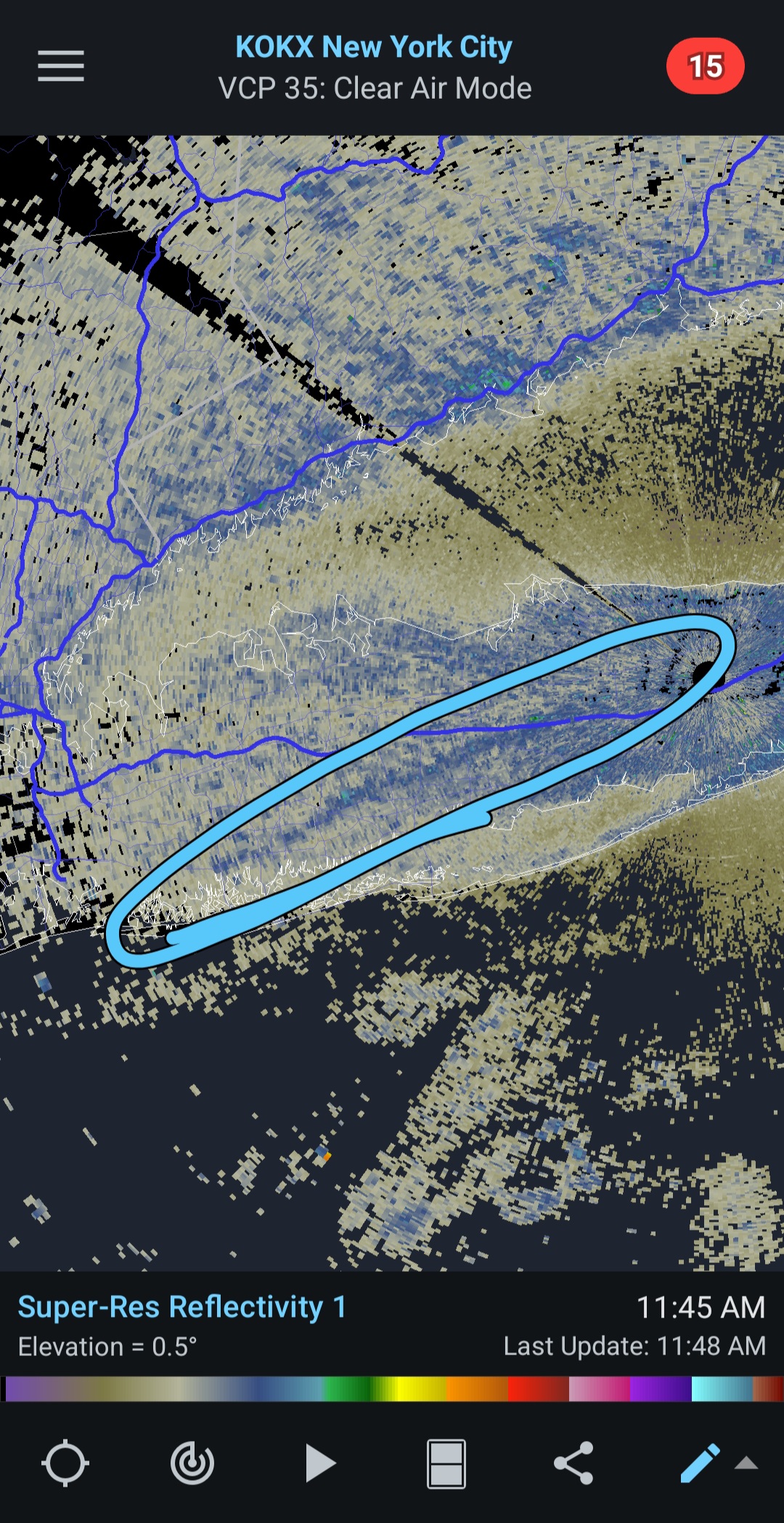
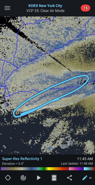
Sea breeze boundary is visible on KOKX radar, slicing through LI southwest to northeast. Dew points have gone back up at places like ISP thanks to the sea breeze. The initial westerly wind this morning that brought in some drier air has subsided
-
Probably a cabin in the Dacks or Moosehead Lake. We just don’t know yet.
-
Looks like our annual fathers day, father/daughter ball park trip is gonna be a wash Saturday.
-
So far so clear
-
Up to 85 here
-
Yeah, it's easy to do. It's been a Thorn more times than not the last few Years.
-
https://www.wunderground.com/dashboard/pws/KNYVALLE15 a high of 89.4 so far near Peninsula Blvd https://www.wunderground.com/dashboard/pws/KNYVALLE55 89.6 https://www.wunderground.com/dashboard/pws/KNYMALVE20 90.8 https://www.wunderground.com/dashboard/pws/KNYHEMPS10 92.8
-
Yes, this is my favorite kind of heat! I don't count the barrier islands as part of Long Island, they are separate islands lol.
-
Upper 80s by me as well
-
The temperature scheme is about 20 degrees off
-
Must be compressional heating. Upper 80s to 90 showing up in places like East Meadow and Valley Stream but the barrier islands are upper 70s. Seabreeze boundary looks like along the Southern State.
-
 Anzed4 joined the community
 -
Exit Velocity? Great—it went 112 MPH off the bat. But was it a hit or a loud out? That’s the part they skip. Launch Angle? That’s cute. Let’s just ignore the fact that launch angle obsession has turned 180 hitters into all-or-nothing flyball machines—producing three true outcomes: walk, strikeout, or home run. Welcome to baseball’s version of roulette. Spin Rate? That’s the holy grail now, right? So pitchers blow out elbows trying to increase RPMs instead of learning to pitch. What happened to command? What happened to working backwards? Analytics made pitchability a dirty word. Metrics Replacing Men They sold us wRC+, xFIP, and CSW%—metrics that tell us what should have happened instead of what did. That’s not baseball. That’s fantasy. Real players fail and fight through it. Real scouts see beyond the stat line.
-
PEI is a snowy place. Charlottetown averages 112”/year.
-
https://www.linkedin.com/pulse/death-diamond-how-analytics-destroying-baseball-from-inside-kelly-qfepe
-
Nice! Welcome to the other side of life Mike!
-
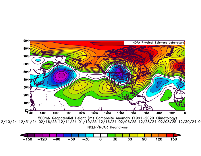
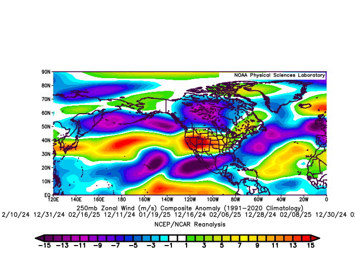
The storm track through the Great Lakes was pushed further north and east than usual resulting in the snowiest February on record in Toronto. So you needed to be far enough north to get into the really good stuff. Plus the record warmth and open waters around Hudson Bay kept the Great Lakes warmer than they typically see during La Ninas since the source region was so much warmer than normal. This residual pattern could have been lingering from the previous winter which was the warmest on record for many spots around the Great Lakes. The custom composites that I generated below isolate the storm track dates. These composites feature the 11 days this past winter that .20 or greater of precipitation fell around NYC Metro. So this was the dominant storm track for my area. The average temperature on these storm dates in NYC was 41°. It’s why the snowfall last winter was so low even though the average winter temperatures for the 3 month period was closer to 35.0°. The La Niña reference to the pattern is how strong the Southeast Ridge was along with the subtropical ridge from near Hawaii into the Southern Plains on the major winter storm track days around the Northeast. Also notice the familiar -NAO Greenland to Iceland block linking with the Southeast Ridge yet again. The La Niña mismatch feature was the stronger -EPO+PNA than usual. The extended Pacific Jet from Japan across the CONUS was also significantly stronger than past La Niña instances. My guess this is a result of the gradient between the record WPAC warm pool and Arctic cold in Siberia. So an enhanced La Niña pattern in some regards with variations leaving some areas of the Great Lakes drier and warmer than usual La Ninas.
-
whats with all the reds on that map lol
-
barrier islands maybe, not around here.
-
Interesting website... never heard or seen it before. What do you think of it?
-
Yes, these are my thoughts too and exactly what I'm hoping for. Variability is muted but eventually the elevated averages will win out and boost maximums to extreme levels. It's happening in the West first because they have dried out. But eventually water vapor won't be able to hold us back from our fate.
- Today
-
lol I have family there, been there dozens of times
-

June 2025 discussion-obs: Summerlike
LongBeachSurfFreak replied to wdrag's topic in New York City Metro
Winds already 15knots SSW at the beach. Seabreeze will keep the south shore significantly cooler today.