All Activity
- Past hour
-
 mexican pharmacy online order: Botica 24 - meds from mexico
-
This area has been the boring weather center for a while now lol
-
-

Fall 2026 Medium/Long Range Pattern Thread
Carvers Gap replied to John1122's topic in Tennessee Valley
One last note, we need to watch the GFS for cold fronts at this time of year. In the past, it generally has performed the best during November and December when sniffing out cold fronts. The Euro usually is better after mid-Dec and through Feb. I don't see much on the GFS(yet) indicating any flip to cold. Right now, it just shows normal cold fronts pushing into warmer air masses. But watch it carefully for the end of the month and earl Dec....it will likely catch any potential shenanigans first. -
2026-2027 Record-breaking El Nino
40/70 Benchmark replied to Stormchaserchuck1's topic in Weather Forecasting and Discussion
Yes, I like a weekly peak between 12/17 and 12/29, which is when 1997 and 1982 peaked, respectively. This yield a NDJ ONI peak. Great assessments this year. -
Fall 2026 Medium/Long Range Pattern Thread
Carvers Gap replied to John1122's topic in Tennessee Valley
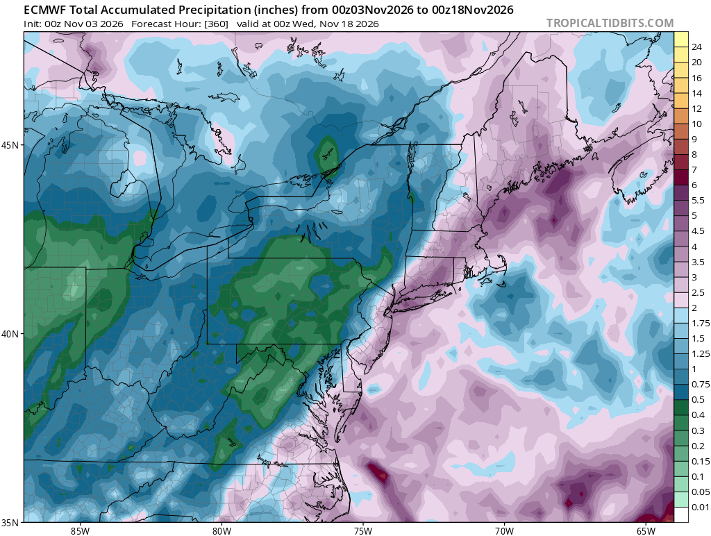
A couple of early morning thought....I am just gonna place a bunch of Nov/winter stuff here. The strat split is probably Nov discussion. So, I am going to file the information here so that it will be easier to find later. 1. Modeling is probably gonna be a mess with a potential disturbance of the strat. If it actually splits, modeling could miss badly on anything depicted after the split. I have seen models show crazy cold over NE TN w/ an SSW predicted at range....only to send it into the West at the last minute. I have also seen models miss the cold. 2. Early stat splits(if it actually splits...what is the timeline on it splitting?) do have some interesting analogs which might prove to be useful too our area. Those were noted above by John. 3. The CANSIPS has been locked into a cold winter for months. However, it flipped November to warm(on this latestt run) after being cold. Really, the most useful CANSIPS(for winter) is the one which is released on Dec 1. It generally is a warm model, so colder solutions are interesting. It also badly missed October. It called for cold, and October was anything but that. Now, I don't necessarily fault a model for busting with shoulder season months. But....its recent track record might be categorized as "abysmal." I am pretty sure it has missed August, September, and October badly. Short story, it seems to be only correcting at the last minute, if at all. It has been a while since it has been correct during the past few months, but it does have a history of some skill during winter. Right now, buyer beware. Let's see what Euro seasonals show. 4. I think modeling is likely correct w/ BN heights over the SE for the second half of winter. I suspect the CANSIPS is over-doing how cold it will be. Ninos have nasty habit of being cloudy, rainy, and just not quite cold enough for snow. That said, the early strat "could" really shake up even the best of LR models. IMHO, and early strat split(IF it actually happens) reshuffles the deck for winter. Ninos often produced big snowstorms, but only a few...with the exceptions being notable winters. 5. Since this is the November thread, I do think we see a very, very slow step down back to normal by the end of the month. There is still a pretty big storm showing up around the last third of the month. It looks like it lacks a cold air source, but higher elevations might want to watch it. The 0z Euro phased the thing w/ northern jet energy(SE of the benchmark?). Modeling, when it picks up big storms like that at range, is often onto something. Looks like a rainer, but could be a strong slp or even a bowling ball low. Something interesting to watch. There is a legit chance for a big flip to cold later during November as warm falls often are followed by that. 6. As several have noted, we need the rain. It has been feast or famine this year w/ rainfall. NE TN generally finds a way "not to rain" at this time of year. 7. Does this El Nino suddenly crash? There are some signals that it might. If so, winter could begin w/ a strong Nino, progress to a weak Nino by the last third of winter, and then descend to neutral by early spring. That would leave a window(and Cosgrove has noted this) for cold and stormy weather during the last half of winter. 8. Of note, the nights have been chilly w/ low humidity ongoing. As soon as the sun goes down, the tempt plummets IMBY. -

2026-2027 Record-breaking El Nino
snowman19 replied to Stormchaserchuck1's topic in Weather Forecasting and Discussion
Another (unsurprising) big drop in the SOI, indicating ocean/atmosphere coupling with the huge WWB. This is going to initiate another round of warming as we approach the final peak of this historic event sometime in December -
I had the standard “night before the forecast snowstorm” dream last night
-

2026-2027 Record-breaking El Nino
SnoSki14 replied to Stormchaserchuck1's topic in Weather Forecasting and Discussion
The writing was on the wall. You're only hope is there's a fluke storm a la 83 or 2015 with just enough cold air around. Wouldn't be surprised to see March pull something out. -
JFM
-
2026-2027 Record-breaking El Nino
40/70 Benchmark replied to Stormchaserchuck1's topic in Weather Forecasting and Discussion
Yea, we were both always suspicious of any major impact from the strat. This is why just shake my head when trolls call me a "denier", etc...I usually keep it pretty real and don't hype anything unless it's truly warranted. -
The weeks between Thanksgiving and Christmas is still in play.
-
Good signs hopefully, with the possible SSW taking place.
-
Getting really boring and dry around here. Good for business but I'm ready for a nice rainy break.
-
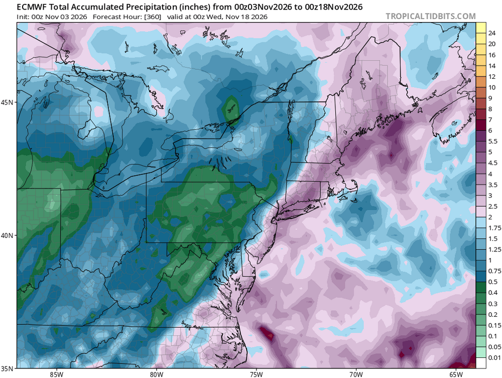
Ugh
-
https://pharmastash.shop/# lowest prescription prices online india
-
What happened to the rain this week? It's looks like it's doing the ole dry on approach we are so use too.
-
45/44, no front this morning
-

2026-2027 Record-breaking El Nino
bluewave replied to Stormchaserchuck1's topic in Weather Forecasting and Discussion
-
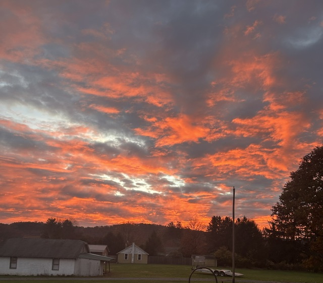
50 degrees another beautiful morning sky.
-

2026-2027 Record-breaking El Nino
MJO812 replied to Stormchaserchuck1's topic in Weather Forecasting and Discussion
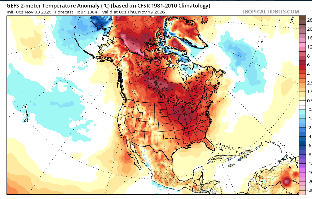
Agree Its November and I am still wearing short sleeves and no jacket. -
43 here.
-
I can see the end of their crack pipe is white hot
-
Central PA Autumn 2026
Mount Joy Snowman replied to canderson's topic in Upstate New York/Pennsylvania
Low of 44. Looks like a couple nice days then hopefully some much needed rain. - Today
-
2026-2027 Record-breaking El Nino
snowman19 replied to Stormchaserchuck1's topic in Weather Forecasting and Discussion
There is going to be a brief wind reversal after the warming but it never couples with the troposphere and with no further “assaults” on the SPV it’s going to strengthen rapidly and likely be strong to very strong by early December. This background state is extremely hostile to sustained weak SPV and SSWEs