All Activity
- Past hour
-
Sure looks like the 18z has held back the energy on this run and sped up the energy flowing underneath. It probably won't get to 12z Euro levels, but that is a big step at 500.
-

Overnight Wednesday, November 5, 2025 Wind Event
Torch Tiger replied to weatherwiz's topic in New England
I'm not really seeing any big changes from 12z near the S shore -
Overnight Wednesday, November 5, 2025 Wind Event
Torch Tiger replied to weatherwiz's topic in New England
pretty much the same as 12z? -
 calling it now - best winter since 14/15
 -

November 2025 general discussions and probable topic derailings ...
CoastalWx replied to Typhoon Tip's topic in New England
You probably have had 6 tornadoes within a 8 mile radius since mehing weather from 2024 on. Including last night. -
Overnight Wednesday, November 5, 2025 Wind Event
CoastalWx replied to weatherwiz's topic in New England
18z GFS backed off too. Time to cancel. -
This country is FUBAR politically but this just isn't the place for effecting change. Many agree with your positions but it is also completely futile to try to convince the rest. So what's the point?
-

12th Annual Mid-Atlantic Snowfall Contest
midatlanticweather replied to RodneyS's topic in Mid Atlantic
BWI: 19.2 DCA: 14.7 IAD: 23.3 RIC: 15.3 Tie Breaker SBY: 6.3 -

Mid to long range discussion- 2025
WinstonSalemArlington replied to wncsnow's topic in Southeastern States
GFS sees snow shower potential in the northeast North Carolina Piedmont and coastal plain on November 13P -

Fall/Winter Banter - Football, Basketball, Snowball?
Carvers Gap replied to John1122's topic in Tennessee Valley
@Mr Bob, @PowellVolzis locked out of his account again. If you can give him a hand, it would be hugely appreciated by Powell. Thank you! -
MRX from this afternoon.... Ridging builds back in Thursday afternoon with warmer temperatures and quasi-zonal flow in the mid and upper levels of the atmosphere.. A more progressive trough will approach the Mississippi Valley by late Friday with an associated surface low pressure near the Great Lakes. A cold front will move eastward across the forecast area Friday night into Saturday morning with widespread showers and thunderstorms expected. A few rounds of shortwaves will strengthen the upper-level trough across the region Sunday night into Monday. Deterministic and ensemble members are in good agreement even this far out from the weekend. The LREF indicates about a 70+ percent chances of temperatures less than 32 degrees across the valley next Monday night, which is a fairly strong signal this far out for a widespread freeze. With northwest orographic flow and 850mb temperatures below 0C, some light snowfall will be possible for higher elevations above 4000 ft across the mountains. A significant return of cold air appears likely early to mid next week bringing an early taste of winter.
-

November 2025 general discussions and probable topic derailings ...
kdxken replied to Typhoon Tip's topic in New England
Ever hike the Grand canyon? They're all over you looking for food. There are signs everywhere not to feed them . -

November 2025 general discussions and probable topic derailings ...
tamarack replied to Typhoon Tip's topic in New England
Wonderful - wish you had caught that on the cellphone. I've only encountered that once, on the south slopes of Bigelow Mt when heading up to audit some forest inventory plots in late October. It was windy but the leafnado came on doubled force with dozens of leaves bouncing off all sides of me. Further up was even windier and the tall spruces were leaning alarmingly with each gust. When I heard a gust coming, I would find a large sugar maple or yellow birch and lean on its lee side, in case one of the nearby spruces decided to give up. I gave up in moderate SN with 1"+ OG. Went down from about 2200' to 1200 and there it was only sprinkling with modest wind. Co-worker was on the north slope and had nothing notable for wind or snow. -
November 2025 general discussions and probable topic derailings ...
kdxken replied to Typhoon Tip's topic in New England
Nasty little things. Always yelling. -
Noticeable trend southward on 12z ensembles. Something to watch, but it is a great example of why looking at 500 maps tells the story. IF(stress IF) that holds, somebody would likely get hammered by that. Definitely will be watching this for a few days. Huge grains of salt as climatology really doesn't support snow this early, but Fountain mentioned a great example above of this actually occurring. It is uncanny how close those maps look. I will be interested to see the trends. Also interesting, 2014-15 turned out to be a great winter. I bet the QBO dipped around then off the top of my head.
-
Its definitely going to warm up after next week's cold shot. The question is what pattern comes next and how long does it take to establish itself.
-
November 2025 general discussions and probable topic derailings ...
kdxken replied to Typhoon Tip's topic in New England
Better than rainy with a high near 43. -

Central PA Fall Discussions and Obs
canderson replied to ChescoWx's topic in Upstate New York/Pennsylvania
Took them long enough to issue the wind warnings. This had been for recast for a week. -
 Thanks. Gunna make sure my garbage cans are tied up.
 -
Compare that GFS ensemble sigma to the Euro operational at the same range....
-

Fall 2025 Medium/Long Range Discussion
HillsdaleMIWeather replied to Chicago Storm's topic in Lakes/Ohio Valley
Looking like lake effect is gonna kick into gear after that system next week -
@fountainguy97, that is uncanny. The 12z Euro drops 16" over the same high elevations spots as it did in 2014. Good find.
-
waiting to make my inauguration day joke again until the dust settles a bit
-
 Just glanced out to see this—thought it was kind of neat. Shadows from Bath being cast across the Kennebec onto Woolwich while the full moon rises. And now the sun has set Sigh.
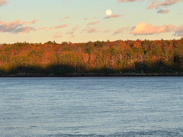
-
Hmmm. Well....


