All Activity
- Past hour
-

2026-2027 Record-breaking El Nino
GaWx replied to Stormchaserchuck1's topic in Weather Forecasting and Discussion
Even if this SSW ends up not propagating downward to a significant degree and thus doesn’t lead to strong -AO/-NAO in Dec, just the fact that this very early SSW is occurring may have implications as to the chance of a subsequent major SSW (i.e., a canary in the coal mine) that actually does downwell significantly and thus leads to a strong -AO/-NAO after that as I think @40/70 Benchmarkhas talked about. -
miss north on the micro spud
-
 Amen brother! I'll add, I lived in many states and I agree with the shout outs for Michigan.... western and northern areas of the state are gorgeous. The only areas I have no desire to be back in are the i-95 cities and the northeast in general, (south of Boston), and the mid atlantic. yuck
-

2026 Atlantic Hurricane Season
TheDreamTraveler replied to Stormchaserchuck1's topic in Tropical Headquarters
Yeah I'd be shocked if we see anything else form at this point. Isaias was basically our Joaquin of the season too. Very interesting season regardless all things considered. Tons of records broken in the opposite direction for once -
It’s amazing how some of these people get so angry and upset about fake cold. Never ceases to amaze the tantrums and anger it generates. A real phenomenon
-
He does fake heat well so I'd say yes.
-
Them and the 2014 Royals (UGH) were two of the greatest bullpens I've ever seen in the playoffs. Pure domination from start to finish. A strong bullpen is such a weapon in today's MLB. I'm happy the Brewers won! I also think Tampa needs to relocate to a better city. That place doesn't care one bit about them.
-

2026-2027 Record-breaking El Nino
Typhoon Tip replied to Stormchaserchuck1's topic in Weather Forecasting and Discussion
Yeah, that's why I'm careful to describe the downward propagating, crucially ...highly indicative using the temperature monitoring... I also am just commenting that perhaps delineating whether that specific behavior is occurring or not, is crucial. Because the correlation to the AO is very tightly correlated to that phenomenon. That site, and the information, at both ends that I provided, coherently show that. If you take those down welling examples, and compare them to historical AO records, you'll see the 20 to 30 day lag rather obviously. If you do the same with those warm nodes that did not apparently propagate, AO responses are variable and very less correlated. I'm also - again - not intending to say this November won't observe a downward inertial displacement, from 10 hPa ..thru the lower pressure coordinates and destined to affect the AO...etc... just that I'm not seeing that type of SSW totality at this time. The gist: What we're getting at here is the well-studied form of stratosphere–troposphere coupling. The current 10 hPa bloop - at least in the GFS suite I provided ...again, I have not seen the Euro and refuse to pay for it hahahaha - does not appear GFS-destined to be a coupled phenomenon. It's not likely to be a deterministic value on the AO and subsequent goodies ...etc... if even registerable at all, unless the coupling model takes place. Critical distinction being ...inertial displacement at 10 hPa only describes the PV's forced horizontal position at that level, not proof that the same displacement is traveling downward... that has to happen or the coupling won't. -

2026-2027 Record-breaking El Nino
FPizz replied to Stormchaserchuck1's topic in Weather Forecasting and Discussion
SOI has been + for 5 straight days now I saw -
"Is this why weekly climate models are now showing cold wintry Dec across the eastern US"? They are??
-
Rain whiffed around this area earlier this morning. Plenty more rain chances over the next week though.
-
 medicine purchase: ZenithIndusRx - india pharmacy online
-
2026-2027 Record-breaking El Nino
Typhoon Tip replied to Stormchaserchuck1's topic in Weather Forecasting and Discussion
Been seeing this a lot in the last decade ...but since 2023, even more, where these "missing man formation" curve peal-aways take place. This tropical curve is exceptionally deviated from the perceived canonical/historic behavior at this point... It seems it should almost have to turn and start going down but the damage is already done. Not sure if this apart/aspect of El Nino, per se; other "super" Nino years are presented but did not to demo this type of aberrant tropical separation from the pact. Interesting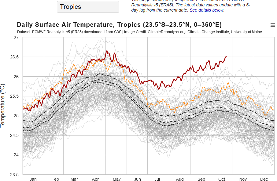
-
Will Atlanta see a frost before you?
-
.42 here overnight with some decent lightning and thunder. Cooler today but still above normal. Highs in the low to mid 50's for at least the next week.
-
https://www.facebook.com/share/v/1M35TsUNUa/
-
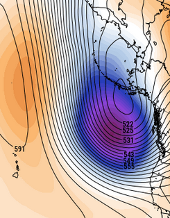
Looking at the EPS spatial/synoptic hemisphere in the mids, thru the end of those 360 hours ... GEFS and GEPS too, it appears it's all coming down to how the planetary wave lengths ( literally the x-coordinate geometry of how long it stretches...) verifies across the continental mid latitudes in determining if/when winter-like anything will take place thru mid month. One aspect that is very high confidence ( unusually so for this range/model error climate) is that a poweful negative goepoential anomaly will set up NE of Hawaii in the E and particular NE Pacific. Not even sure if this is an Aleutian low" per se, as it is not really illustrating ling that. More like a deep L/W anchor trough, with perhaps a few member likely closing off a low at some point or another but also likely remaining progressive just by experience of of what the mean looks like - for now... But it is deep, and it is a very strong +PNA correlation, thus seeing this ... ...has herculean legs supporting confidence. Perhaps also considering just how ridiculously crushed those members are surrounding that mean curve... The mode/mean are collocated as is almost all members, out at D10? that is a raging agreement hard-on. Convention of statistics states that lower spread is consistent with elevating confidence. Anyway, back to point ... the spatial/synoptic handling down stream of this look E Pac aspect is not nearly as coherent as this E Pac aspect, It's like an 'unmanned fire-hose' pattern down stream, where the models will tend to flop the heights and whatever impression of a ambient polar jet up and down in latitude just like a model-time-dependent flopping fire hose. Run to run, different location while the E Pac look essentially remains the same. We're creating a pattern here where the western half of the PNA domain is anchoring in positive mode, but the eastern half is indicating stress coupling... a variation that could either result warm or cool relative to normal.
-
Pre or around Thanksgiving snow has historically been the kiss of death for the rest of the winter.
-
The weather is so boring! This is the Snotober and Sandy anniversaries!
-
Fake ?
- Today
-
2026-2027 Record-breaking El Nino
GaWx replied to Stormchaserchuck1's topic in Weather Forecasting and Discussion
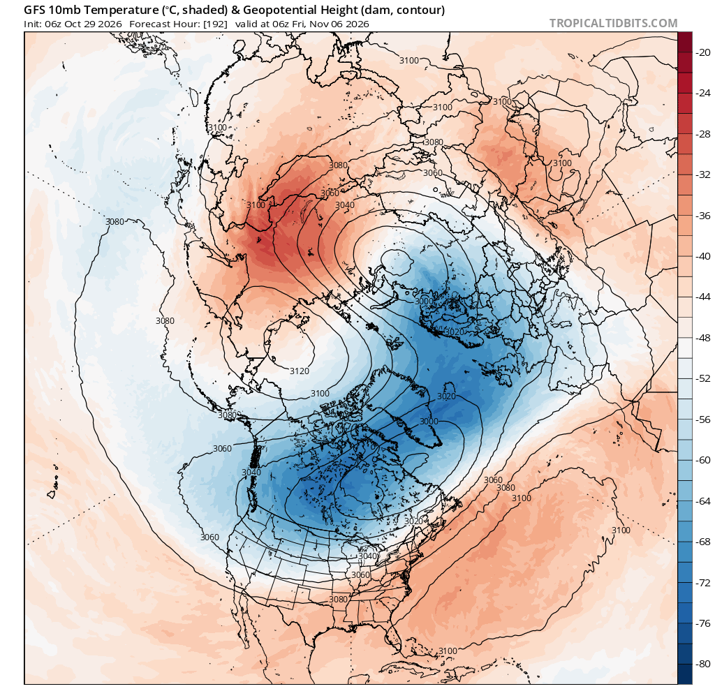
John, As long as the 10 hPa/60N mean zonal winds reverse (go to <0) in Nov or winter, that event is defined as a major SSW regardless of the degree of actual strat. warming and degree of propagation down into the troposphere, if at all. If it doesn’t drop to <0, the strat warming event is called a minor SSW. Despite the reversal or at least near reversal being progged on models, the degree of actual warming at 10 hPa being progged has been tame compared to many other SSWs. So, that could very well be a factor to consider as regards its potential to later significantly disrupt well down into the troposphere. I wonder if that reduces that potential. Opinions? Check out this GFS prog, for example. The change in the strat. wind pattern at 60N looks quite impressive, but the degree of strat. warming up there doesn’t as there usually are widespread red colors, including dark red, that abruptly move into the area located within 60-90N but in this case the darker reds largely remain in and near Siberia: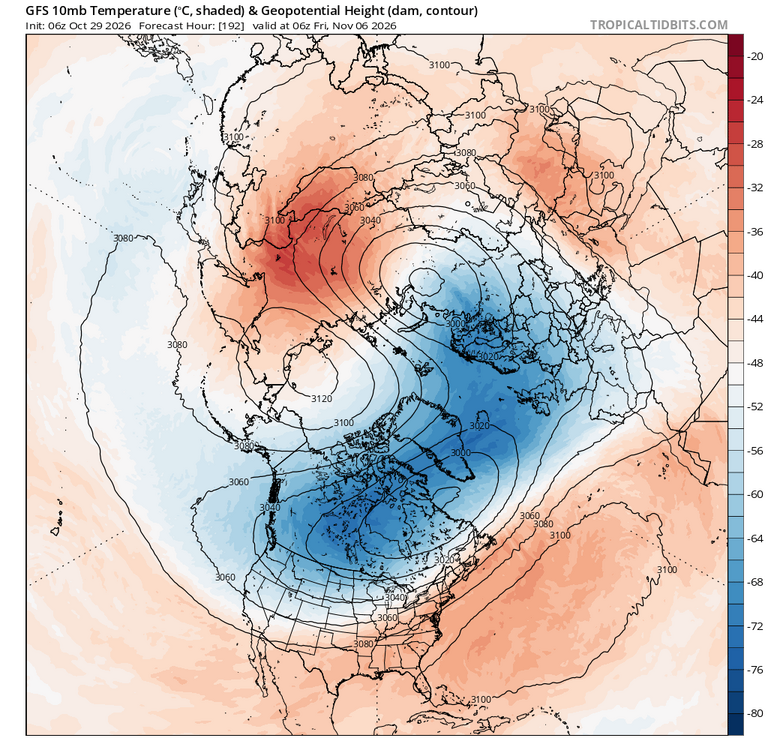
-
We had a big dog last winter, 12-16" locally. It would be unprecedented for us to have another one this year since they tend to occur every 13 or 14 years lol. But this does seem like one of those winters that could be mainly mild throughout but also hold a couple of surprises for the forum. Crazy cutoff lows generating enough cold for snow, perfectly timed, juiced up phasing, etc. Even 97-98 had a crazy storm that pummeled the southern OV in the middle of an otherwise, boring, mild, el nino winter. I still love a good snowstorm but with my growing intolerance for cold, this could be the perfect winter.
-
Kev, maybe you should set up a little vegetable stand in your front yard….”Kevin’s extended season farmers market.”
-
Only a matter of time...
-
Cape's going to luuuuuuuuv your posting that map. Lol