All Activity
- Past hour
-
It doesn't really factor in when NYC and JFK don't factor in. The 40s and 50s were quite a bit hotter. I know you like to use micronets but perhaps if we had micronets in the 90s they would have been even hotter. Hell, I'm going to start using my car thermometer lol. Back in 1993 my car thermometer registered a temperature of 106 degrees driving through Queens which was only matched in 2010 and 2011. Why don't we wire in everyone's car thermometers into the micronet that way we can cover the entire region?
-
Timing of the front looks a bit slow for us. Needs to speed up a few hours.
-

2025-2026 ENSO
40/70 Benchmark replied to 40/70 Benchmark's topic in Weather Forecasting and Discussion
Yea, ACE is more predictable.....obviously the most important factor is land impact. -
I'd like to thank the GFS for being good for like 6-12 months forcing the ECMWF to give the Euro away for free.
-
2025-2026 ENSO
40/70 Benchmark replied to 40/70 Benchmark's topic in Weather Forecasting and Discussion
No matter how cool and wet it seems, in this day and age its always going to end up one of the warmest (insert timeframe) on record. -
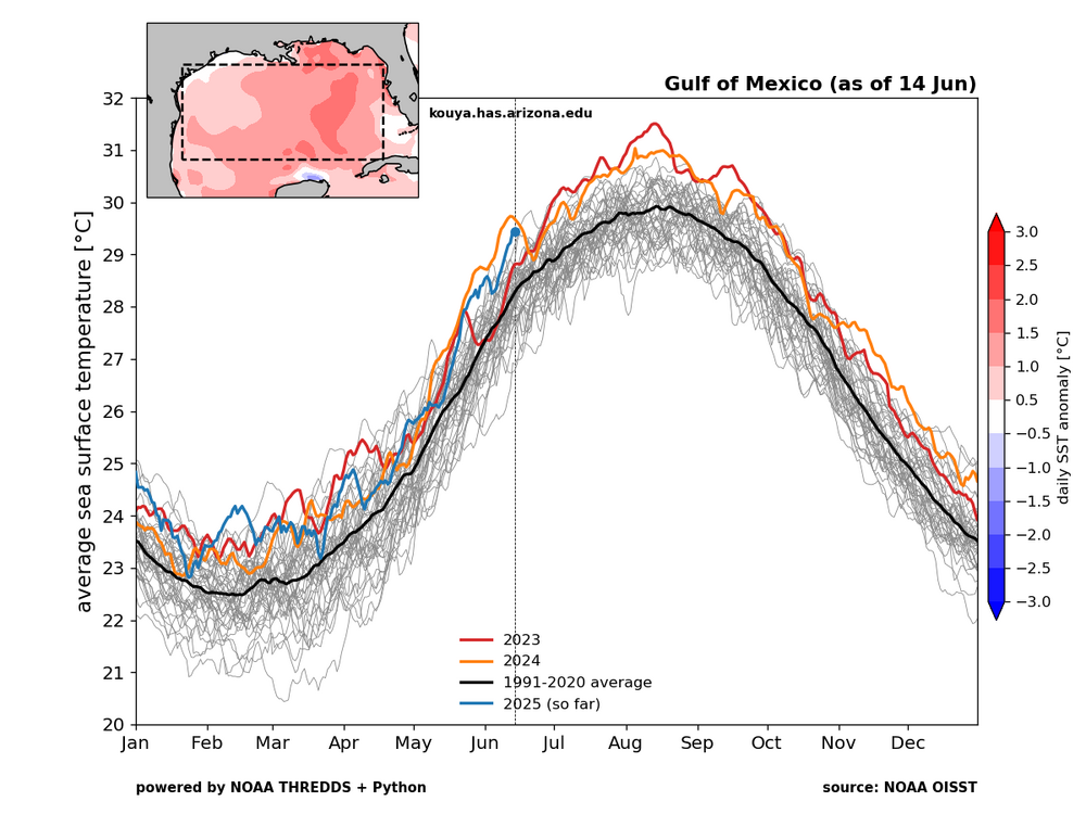
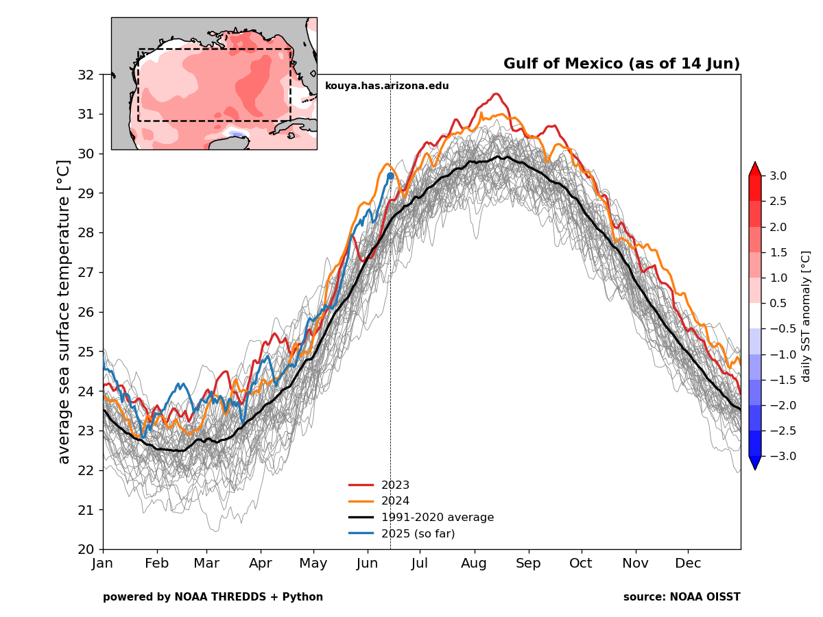
I come at it from a different point of view. ACE is only relevant if storms are making landfall. We can remember 2010 with the very high ACE and the dominant OTS storm tracks. 1992 was a very low ACE season but we had Andrew. But the most significant seasons feature high ACE and landfalls. So sometimes we get caught up in seasonal forecasts of overall ACE. But my focus is landfalling storms. That being said, we have been in a record landfalling hurricane pattern in the Gulf since 2017. The Gulf SSTs are currently the 2nd warmest on record for this time of year. So I will consider this a big season if the Gulf sees another major hurricane landfall by the end of the season no matter what the ACE finishes at.
-
2025-2026 ENSO
40/70 Benchmark replied to 40/70 Benchmark's topic in Weather Forecasting and Discussion
Oh, mercy...I don't even count him as a reputable source. -
No changes from my Sunday morning post... except to add the small potential for a nw flow severe event Sat afternoon, especially eastern parts of our area (CT/LI). That in addition to whatever happens this Thursday as currently outlooked by SPC. I looked at XMACIS and there just isn't any need from my perspective for a heat thread. What is coming is sort of normal for June, especially interior. The sudden change will take a few by surprise but little doubt in my mind we experience heat advisory (June 95-100) interior Thu afternoon, and then possible heat warning or however the NWS titles it for early next weeks MAX HI 100-105. Duration (4 day or 7day+ heat wave of 90+uncertain for KEWR) but I think heat wave likely begins Sunday afternoon. Right now WPC max HI only goes out to Monday and is more conservative.
-

2025-2026 ENSO
PhiEaglesfan712 replied to 40/70 Benchmark's topic in Weather Forecasting and Discussion
It was only average in number of named storms. If you take a deeper look, 2013 finished with a Top 10 lowest ACE season, with only 2 hurricanes, and no major ones. (Even 2014 didn't go that low in those respects.) 2013 put up some numbers that seem unfathomable in this 21st century climate, especially coming off 3 very active seasons. It's a well-below average season. -
All Cold All The Time.
-
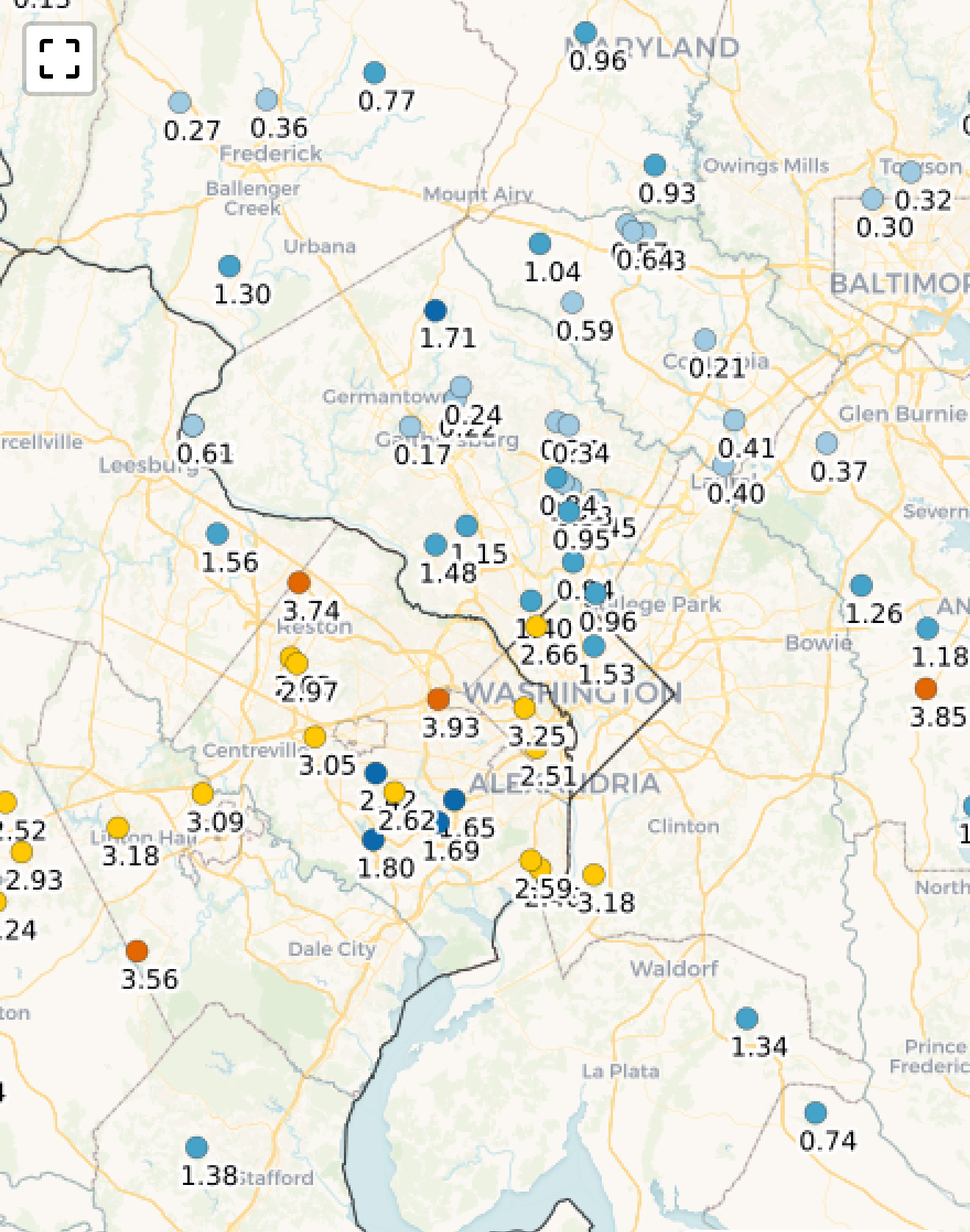
62 / 58 day 3 and hour 58 of the latest cloud invasion. 0.89 in the bucket since Friday night. Cloud lingering much of the next 36-42 hours keeping temps more like April but there is heat (light) at the end of the proverbial dingy grey tunnel we have been in. Warmer by Wed but front is still pushing the boundary north to trigger storms but we should see some sun and spike temps into the 80s. Chance of storms Wed and Thu evening. Thursday, pending on clouds sees >16c 850MB temps and the chance of the next 90s for some and first for many. In what could be a period of 8 of 10 90 degree days (6/20 - 6/30) with heat building north and east and a strong ridge pushing heights to >588- 594 DM next week. Watch for any undercutting the ridge to create any onshore for coastal sections. Hot period with an overall higher heights warm-hot but could be featuring storms potential in the beyond. 6/16 - 6/18 : Clouds cooler - warmer wed 0.25 - 0.45 inches forecast (scattered) 6/19 - 6/20 : Warmer - hot in areas (6/19) 6/20 - 6/30 : Hotter with strong ridge into the EC - could remain with storm potentials keeping it Beyond : overall wetter and hot
-
JB is going for a high ACE Atlantic season with above average storms as he normally does. Wants an excuse to predict a -NAO winter
-
Mid 100s deep into Suffolk County is beyond just being summer. That is historic
-
The drought in AA County is definitely completely dead. It's actually pretty swampy here in the lowlands. Today looks like a nice day to take off work due to weather and go for a long hike before the heat kicks in for the next 4 months.
-
This could be our first decade since the 1950s with 3 years reaching 100 in June and we are only 6 years in.
-
That’s funny coming from the number one AC pusher man on the forum.
-
It will be at the very end of its range, but I'm curious to see what the 12z NAM comes up with Thursday afternoon into the evening
-
Heres your weekly "what is this" post from me... can someone explain ACATT...? Thanks
-
EPS is historically hot this far out. This is no typical heat signal
-
This is a crazy signal this far out. Something historic is brewing
-
Weather folks are putting in the work to let people know the heat is coming.
-
I’m going to ignore all the places that haven’t reported yet, and radar estimates, and declare myself the three-day winner

-
Not sure, but I think Iran is presently receiving unprecedented heat bursts...
-

Central PA Summer 2025
Mount Joy Snowman replied to Voyager's topic in Upstate New York/Pennsylvania
Low of 58 and .15” of rainfall. -
Steady rain again i suppose if it's going to be mid upper 90s soon i'm happy to get as much ground water as possible. I do need to mow though


.thumb.png.4150b06c63a21f61052e47a612bf1818.png)