All Activity
- Past hour
-
It is pretty active now with a south Bz. Don't snooze on tonight.
-

2025-2026 ENSO
40/70 Benchmark replied to 40/70 Benchmark's topic in Weather Forecasting and Discussion
1995-1996 2014-2015 2010-2011 2004-2005 2017-2018 2002-2003 -

2025-2026 ENSO
michsnowfreak replied to 40/70 Benchmark's topic in Weather Forecasting and Discussion
My favorite going back to 1990: 2013-14 2010-11 2007-08 2014-15 2004-05 2002-03 2008-09 2017-18 2000-01 1998-99 -
Yeah go team save Scott’s sanity. Ha
-
Happened again today. Nice storm, drifting northwest. I'm about 10 miles as the crow flies from Kiowa. By the time the storm got to me, it was sprinkles.
-
18Z euro also moved the wet axis north similarly.
-
That’s the likely scenario despite what Kooky Kenny thinks . Wagons north
-
Surf zone looks to warm finally by hour 348. https://x.com/RyanMaue/status/1929537625993412839
-
18 ZGFS looks pretty good for Saturday …has the front pounding PF’s butt but it’s warm sector southeast of there
-
Highs today PHL: 75 EWR: 75 TEB: 74 ACY: 74 LGA: 73 New Brnswck: 73 JFK: 72 BLM: 72 ISP: 71 TTN: 71 NYC: 71
-
Can you imagine. Panicked over .31 inches of rain? Now THAT is Stein.
-

2025 Spring/Summer Mountain Thread
Maggie Valley Steve replied to Maggie Valley Steve's topic in Southeastern States
It was almost a perfect day, less that pesky Canadian smoke. Low was 56 and the high was 73 at the house today! - Yesterday
-
Yeah it was the Connecticut river valley that got swamped. Some were saying It was going to be way west. You knew...
-
Stick with your gut
-
Here it comes... it's only showers. Is your stepchild on board?
-
I don’t know. We shook.
-
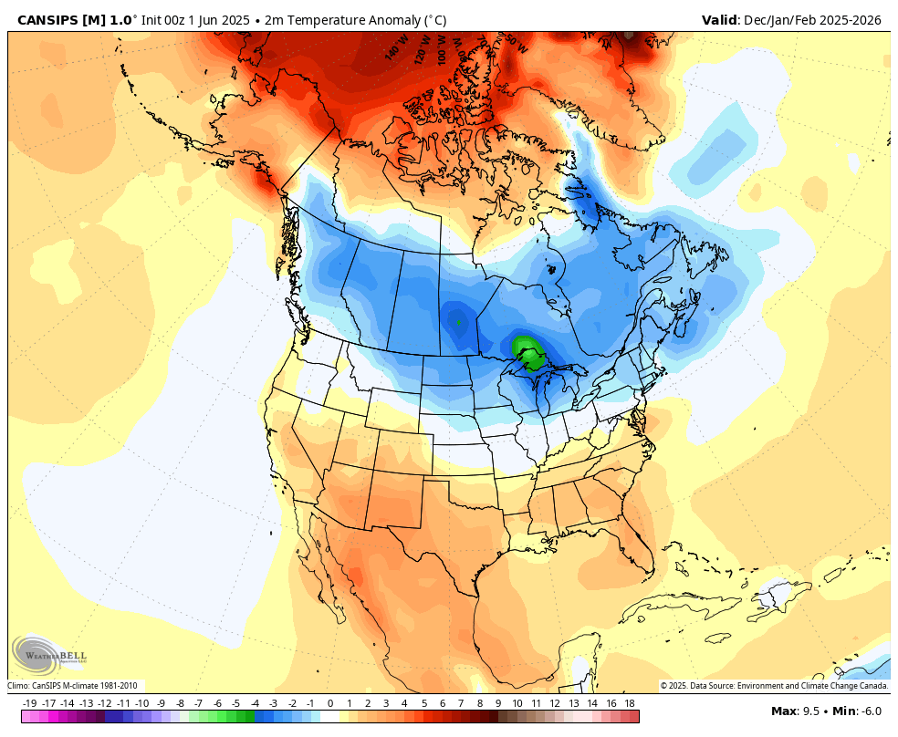
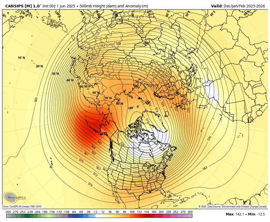
WB 6/1 Can. Seasonal Dec.- Feb.)


-

2025 hurricane season forecast contest -- enter by June 7 06z
nvck replied to Roger Smith's topic in Tropical Headquarters
18/9/4 -
Yes and it's not always about ENSO either. My favorite winters were a combo of different things. 1993-94 1995-96 2002-03 2009-10 2010-11 2013-14 2014-15 2017-18
-
and the solar maximum (though it's really great for northern lights displays even in the south.)
-
A dramatic warmup will is now imminent. The temperature will soar into the upper 70s to around 80° tomorrow and into the 80s by Wednesday. The temperature could reach the hottest levels so far this year on Thursday. Parts of the region could reach 90° for their first time this year. Temperatures will remain above normal into the weekend. The ENSO Region 1+2 anomaly was +0.2°C and the Region 3.4 anomaly was -0.2°C for the week centered around May 21. For the past six weeks, the ENSO Region 1+2 anomaly has averaged +0.08°C and the ENSO Region 3.4 anomaly has averaged -0.08°C. Neutral ENSO conditions will likely continue through at least mid summer. The SOI was -6.75 today. The preliminary Arctic Oscillation (AO) was +1.534 today.
-
 17/8/4
 -
I'm still not seeing any heat this week with possibly one or two days in the June 11-14 time-frame. But overall it does not to me like an above normal temperature pattern for our area. I'm aware some of the longer range guidance has a ridge over the eastern Canada and the Maritime Provinces nosing back towards us but that is really not a heat signal for the big cities of the northeast and coastal sections. We do not want to see high pressure set up so close to us or in the coastal waters se of New England. It's very much an over the top type of signal and the flow remains active with lots of cold fronts and an active storm track. The warm days are mostly low-mid 80s, yes high overnight minimums sometimes but also a cool push of air every so often. Looks near to perhaps slightly below normal temps to me and wetter than normal for most of us. WX/PT
-
2025-2026 ENSO
40/70 Benchmark replied to 40/70 Benchmark's topic in Weather Forecasting and Discussion
NNE did fine....it's SNE that keeps getting the train run on it by mother nature. -
2025-2026 ENSO
40/70 Benchmark replied to 40/70 Benchmark's topic in Weather Forecasting and Discussion
Yea, I think the real flip is near the turn of the decade.