All Activity
- Past hour
-

Pittsburgh/Western PA WINTER ‘25/‘26
ChalkHillSnowNut replied to Burghblizz's topic in Upstate New York/Pennsylvania
Dang Steel City is back too!!! Missed all you! -

Saturday night/Sunday 12/13-12/14 Jawn
zenmsav6810 replied to Ralph Wiggum's topic in Philadelphia Region
I think Huff's Church and Mertztown stand a good shot. Morgantown and French Creek SP too. -
Moderate snowfall 12/14/2025 WWA up for most of the area
wthrmn654 replied to WeatherGeek2025's topic in New York City Metro
38 out here awaiting flakage -
Southern MD / Lower Eastern Shore weather discussion
SnowtoRain replied to PrinceFrederickWx's topic in Mid Atlantic
38.7, dp 33.1, 2" looks to be the high end bar, 1 to 1.5" seems reasonable for my part of the midshore -

12/14: Sunday funday? Will the south win again?
dailylurker replied to TSSN+'s topic in Mid Atlantic
I just ate a 150 milligrams of thc that I grew in my garden. I'm hoping for a spiritual, magical, Christmas Jebwalk around midnight. If i see any rouge snow piles I'll definitely give them a wack with my shovel for ya. -
URGENT - WINTER WEATHER MESSAGE National Weather Service Baltimore MD/Washington DC 701 PM EST Sat Dec 13 2025 DCZ001-MDZ008-011-013-014-016-018-503>506-508-VAZ053-054-506-140815- /O.CON.KLWX.WW.Y.0028.251214T0500Z-251214T1500Z/ District of Columbia-Cecil-Southern Baltimore-Prince Georges-Anne Arundel-Charles-Calvert-Northwest Montgomery-Central and Southeast Montgomery-Northwest Howard-Central and Southeast Howard-Southeast Harford-Fairfax-Arlington/Falls Church/Alexandria-Eastern Loudoun- 701 PM EST Sat Dec 13 2025 ...WINTER WEATHER ADVISORY REMAINS IN EFFECT FROM MIDNIGHT TONIGHT TO 10 AM EST SUNDAY... * WHAT...Snow expected. Total snow accumulations between 1 and 3 inches. * WHERE...Portions of DC, central, northeast, northern, and southern Maryland, and northern Virginia. * WHEN...From midnight tonight to 10 AM EST Sunday. * IMPACTS...Plan on slippery road conditions. * ADDITIONAL DETAILS...Precipitation may briefly start as rain in some locations this evening but quickly turn to snow. A narrow band of heavier snow may develop during the late evening and overnight which could produce more rapid accumulations and visibility less than one half mile.
-
It lit up some clouds over downtown silver spring at sunset
-
MDZ004>006-507-140815- /O.CON.KLWX.WW.Y.0028.251214T0100Z-251214T1200Z/ Frederick MD-Carroll-Northern Baltimore-Northwest Harford- 701 PM EST Sat Dec 13 2025 ...WINTER WEATHER ADVISORY REMAINS IN EFFECT UNTIL 7 AM EST SUNDAY... * WHAT...Snow expected. Total snow accumulations between 1 and 3 inches. Localized totals of 4 to 5 inches are possible, especially across northern Frederick, Carroll, Baltimore, Harford, and Carroll counties. * WHERE...Carroll, Frederick MD, Northern Baltimore, and Northwest Harford Counties. * WHEN...Until 7 AM EST Sunday. * IMPACTS...Plan on slippery road conditions. * ADDITIONAL DETAILS...Precipitation may briefly start as rain in some locations this evening but quickly turn to snow. A narrow band of heavier snow may develop during the late evening and overnight which could produce more rapid accumulations and visibility less than one half mile. Highest totals look to be just north of I-695 and I-70. Other roadways likely to see impacts include MD-136, MD-145, MD-24, and I-83 points north toward the PA/ MD line.
-
Saturday night/Sunday 12/13-12/14 Jawn
CoolHandMike replied to Ralph Wiggum's topic in Philadelphia Region
I'll be sure to report -
O.EXA.KLWX.WW.Y.0028.251214T0500Z-251214T1500Z/ Western Loudoun- 701 PM EST Sat Dec 13 2025 ...WINTER WEATHER ADVISORY IN EFFECT FROM MIDNIGHT TONIGHT TO 10 AM EST SUNDAY... * WHAT...Snow expected. Total snow accumulations between 1 and 3 inches. * WHERE...Western Loudoun County. * WHEN...From midnight tonight to 10 AM EST Sunday. * IMPACTS...Plan on slippery road conditions. * ADDITIONAL DETAILS...Precipitation may briefly start as rain in some locations this evening but quickly turn to snow. A narrow band of heavier snow may develop during the late evening and overnight which could produce more rapid accumulations and visibility less than one half mile.
-

Saturday night/Sunday 12/13-12/14 Jawn
zenmsav6810 replied to Ralph Wiggum's topic in Philadelphia Region
Flurries started at 5:45PM in Boyertown as I was driving back home from my first shift this season instructing at Bear Creek Ski resort. -
Anybody else see that orange shaft of ligh from the sun at sunset ?
-
Saturday night/Sunday 12/13-12/14 Jawn
MGorse replied to Ralph Wiggum's topic in Philadelphia Region
A few sprinkles here. -
Winter Weather Advisory extended to western Loudoun County
-

December 14th - Snow showers or Plowable snow?
moneypitmike replied to Sey-Mour Snow's topic in New England
Police helicopters flying overhead now. Hope they catch this guys soon. -
Pittsburgh/Western PA WINTER ‘25/‘26
Burghblizz replied to Burghblizz's topic in Upstate New York/Pennsylvania
Picked up here in Cranberry. Decided to go out to dinner. Roads are trash, but beautiful night. About 2.5” so far. -

December 2025 Short/Medium Range Forecast Thread
Matthew70 replied to John1122's topic in Tennessee Valley
MJO for the win please! - Yesterday
-
Moderate snowfall 12/14/2025 WWA up for most of the area
lee59 replied to WeatherGeek2025's topic in New York City Metro
Flurries here, 36.4 degrees -
Actually moderate, but I will take 3-4. That seems to be the high end for here.
-
December 14th - Snow showers or Plowable snow?
tavwtby replied to Sey-Mour Snow's topic in New England
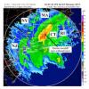
might be some sublimation issues north where it's cold up there under the DGZ, we'll see if we can get a good burst of nice rates and accumulate a couple/three inches. -

December 2025 Short/Medium Range Forecast Thread
Matthew70 replied to John1122's topic in Tennessee Valley
THIS! Tomorrow will be brutal. The January fronts like this one will be even more brutal. -
-
Pittsburgh/Western PA WINTER ‘25/‘26
RitualOfTheTrout replied to Burghblizz's topic in Upstate New York/Pennsylvania
It was an unmitigated disaster in the last 10 minutes. I'm sure Rust will be reliving hitting the post with an empty net, but up 2 goals still at that point it shouldn't have been necessary to score anyways. -

Moderate snowfall 12/14/2025 WWA up for most of the area
WE GOT HIM replied to WeatherGeek2025's topic in New York City Metro
we did it everyone congrats!





.thumb.png.515a50e5c53832a00c5c315379778f68.png)