All Activity
- Past hour
-
That's not how it went down. Nothing here about a weenie. You got annoyed because you said something ridiculous and I called you out. IDGAF about an emote. You do the weenie thing constantly though, because- you butthurt boy. Carry on being a shit poster.
-
Thanks jaxjagman .
-
We also have a marginal slight and moderate risk for excessive rainfall as well majority of tn with moderate in Ky and also nosing in north east middle tn .
-
...Mid-South/Tennessee/southern Kentucky to North Carolina... Multiple MCVs, including across far south-central Missouri and southeast Kansas at midday, will influence the region as they progress east-southward generally toward Kentucky and Tennessee. Related flow enhancement is evident in regional WSR-88d VWP data, and particularly in the 12z Lamont, OK observed sounding (40+ kt 4-9km AGL). See Mesoscale Discussion 1346 for additional short-term details. These MCVs will influence and semi-focus thunderstorm development within a moist and increasingly unstable boundary layer from the southeast Missouri/northeast Arkansas border vicinity into Kentucky and Tennessee. This includes the possibility of some supercells and well-organized clusters in the presence of 35-40 kt effective shear. Pockets of wind damage will be the most common risk, but some tornado potential will exist as well. Additional severe storms capable of wind damage are also expected farther eastward into the Carolinas this afternoon through around mid-evening.
-
#MeToo
-
Just upgraded to slight with 2% to 5% non hatched tornado risk and 5% to 15% damaging wind risk no hail threat .
-

2026-2027 Super El Nino
snowman19 replied to Stormchaserchuck1's topic in Weather Forecasting and Discussion
No, it’s not basin-wide like 2015. Since the biggest player this winter, by far and away is going to be a record-breaking super El Niño, 2009-10 doesn’t match, not one iota. This Nino is going to be a completely overwhelming signal that will trump anything else in the atmosphere or the rest of the oceans. It’s not an analog, not even close. We disagree. This is going to be a very easy winter to predict, there’s nothing hard or challenging about it, not at all. Easiest one in years. And I don’t agree at all with your assessment that this El Nino developing like 2015-16. This one is very, very clearly east-based and it’s going to stay that way. We can split atoms all we want and say it’s “hybrid”, “basin-wide”, “migrating Modoki”, “in betweener” or whatever other adjectives we can come up with and it’s not going to change that fact. It’s been abundantly clear for a month now that this is easily going to be the strongest super El Niño since 1950, at the very least, more likely the strongest one of all time, both in RONI and ONI -
Sure is gross out here in the city now. Even with the clouds the UHI effect is substantial.
-
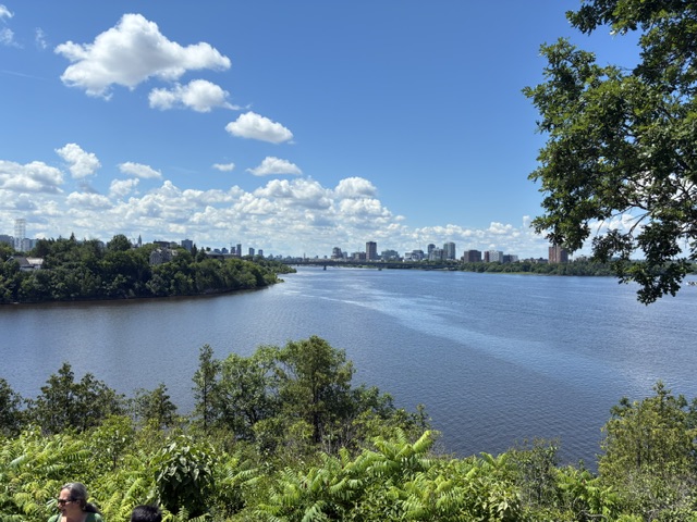
Beautiful day in Ottawa.


-

E PA/NJ/DE Summer 2026 Obs/Discussion
RedSky replied to PhiEaglesfan712's topic in Philadelphia Region
Really like extremes let's do 104F * I see ecm has 109F in Philly Friday hot damn! -

2026-2027 Super El Nino
40/70 Benchmark replied to Stormchaserchuck1's topic in Weather Forecasting and Discussion
I don't think it is a terrible analog for certain points throughout the second half of the season. I don't know why you continue to perceive analogs as being some absolute inference of a replica season. It's akin to tossing the 1997 analog because this one is more basin wide, which would of course be folly. -
Special Marine Warning ANZ430-271745- /O.NEW.KPHI.MA.W.0058.260627T1639Z-260627T1745Z/ BULLETIN - IMMEDIATE BROADCAST REQUESTED Special Marine Warning National Weather Service Mount Holly NJ 1239 PM EDT Sat Jun 27 2026 The National Weather Service in Mount Holly NJ has issued a * Special Marine Warning for... Upper Delaware Bay... * Until 145 PM EDT. * At 1238 PM EDT, a strong shower was located 9 nm southwest of Stony Point, moving east at 20 knots. This shower may strengthen into a thunderstorm. HAZARD...Wind gusts 34 knots or greater. SOURCE...Radar. IMPACT...Small craft could be damaged in briefly higher winds and suddenly higher waves. * Locations impacted include... Woodland Beach, Sea Breeze, Stony Point, Ship John Shoal Light, and Reedy Point. PRECAUTIONARY/PREPAREDNESS ACTIONS... Move to safe harbor immediately as gusty winds and high waves are expected. && LAT...LON 3956 7562 3961 7545 3952 7538 3951 7539 3949 7536 3945 7533 3943 7534 3943 7532 3927 7520 3928 7560 3929 7555 3930 7555 3941 7562 TIME...MOT...LOC 1638Z 257DEG 20KT 3939 7569 HAIL...0.00IN WIND...>34KTS $$ Gorse
-
2026-2027 Super El Nino
40/70 Benchmark replied to Stormchaserchuck1's topic in Weather Forecasting and Discussion
I'll take the 2014 shut out. -
Heavy rainfall producers near Warick, MD and Middletown, DE Vandyke, DE. seems to be center point for max rainfall.
-
EWR top temps last 8 years Year #1 #2 #3 #4 #5 2025 103° (Jun 24) 101° (Jun 23) 101° (Jun 25) 101° (Jul 29) 100° (Jul 8/25/30 tie) 2024 100° (Jun 21) 100° (Aug 1) 99° (Jun 23) 99° (Jul 16) 98° (Jun 26/Jul 15 tie) 2023 97° (Sep 6) 96° (Jul 27) 96° (Sep 7) 95° (Jul 12) 95° (Jul 28/Sep 5 tie) 2022 101° (Aug 9) 99° (Jul 1) 99° (Aug 8) 98° (May 31) 98° (Jul 12/Aug 4 tie) 2021 103° (Jun 30) 102° (Jun 29) 99° (Jun 28) 99° (Aug 13) 98° (Aug 12) 2020 96° (Jul 19) 96° (Jul 20) 95° (Jul 2) 95° (Jul 5) 94° (Jul 3) 2019 99° (Jul 21) 98° (Jul 20) 97° (Jul 19) 96° (Jul 5) 96° (Jul 22) 2018 98° (Jul 2) 97° (Aug 29) 96° (Aug 28) 95° (Jul 5) 95° (Jul 4)
-
You made a conscious choice to make posts complaining about a rating, if it's getting you THAT bent out of shape then that's a you problem.
-
It's funny that for days the models showed the heavier rain missing to the south.
-
Dude you weenie everyone who doesn't agree with your takes (usually wrong) in every thread. It's YOU getting butthurt. Carry on being an annoying crappy poster who contributes nothing of substance.
-
Happy belated to you!
-
There are ratings? Lol
-
.14" sometime overnight. It will be a mercury-type barren landscape here by the 4th of July.
-
Said the person who made multiple posts getting butthurt over a rating. I get weenied a lot too but you don't see me whining about it.
-
You are in here acting like a child because you don't like the observations of others. It's pretty clear based on guidance and actual forecasts that this will not be a widespread rainfall for the region that will have a meaningful impact on the drought. Some locales have/will get lucky with some rain. Disagree?
- Today
-
Yes , I’m actually happy about it though because my area of north jersey missed out on the heaviest the past week. Just a bad job by all models though
-
A huge wildcard in the forecast. I think we’d all welcome the drought and heat relief it would bring. Google (GOAT) DeepMind is enticing.


