All Activity
- Past hour
-
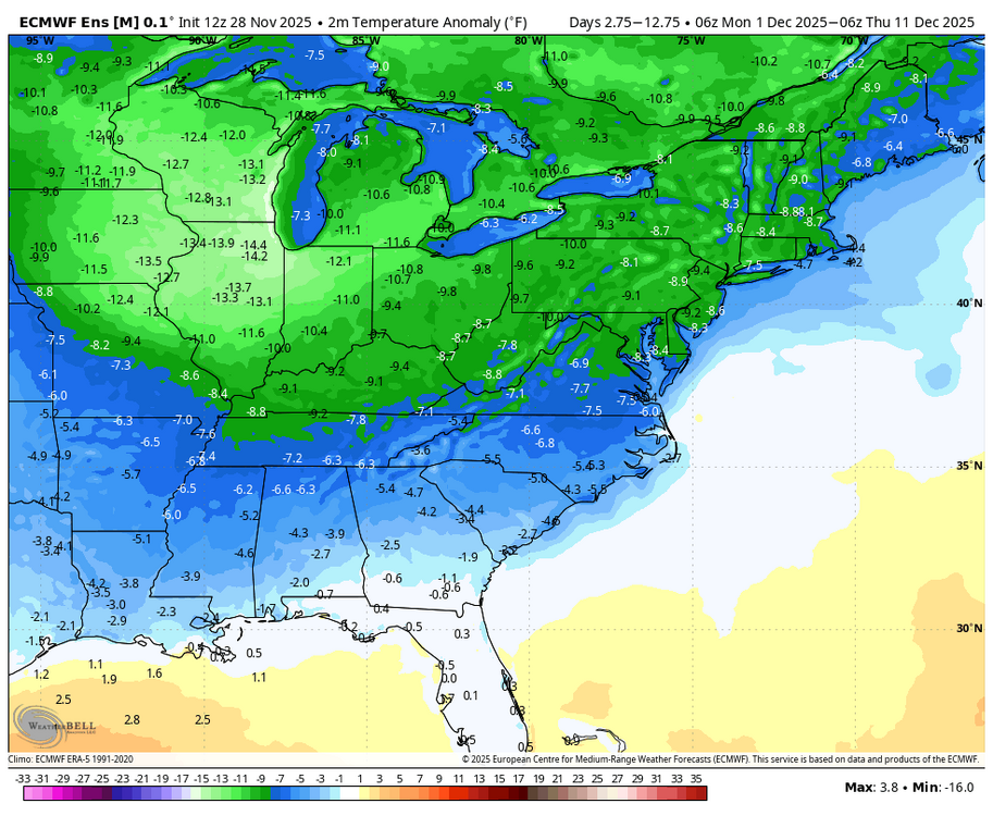
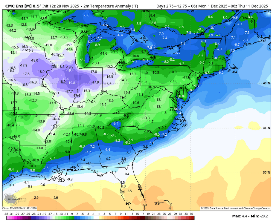
12Z EPS held onto its 0Z significantly colder temps vs 0Z GEFS. But also, 12Z GEFS came in significantly colder than 0Z GEFS: 0Z GEFS: 12Z GEFS: colder/in EPS direction: 12Z GEPS came in much colder than 0Z GEPS: 0Z GEPS: 12Z GEPS: colder than 0Z GEPS

-

November 2025 general discussions and probable topic derailings ...
powderfreak replied to Typhoon Tip's topic in New England
That’s one helluva band right through ALB airport area.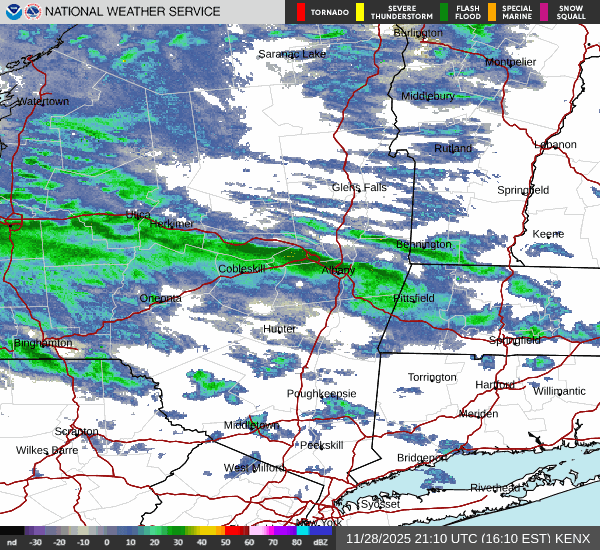
-

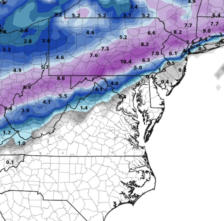
Nov 28-30th Post Turkey Day Winter Storm
Chicago Storm replied to Chicago Storm's topic in Lakes/Ohio Valley
this whole thing is essentially waa. -
Kraft or die.
-
Icon getting interesting for the coast
-

Nov 28-30th Post Turkey Day Winter Storm
A-L-E-K replied to Chicago Storm's topic in Lakes/Ohio Valley
Radar looks good, early weenie waa will make or break -
Hopefully
-

First Winter Storm to kickoff 2025-26 Winter season
ORH_wxman replied to Baroclinic Zone's topic in New England
Lots of posters will be disappointed if Stowe doesn't add onto their record or near-record early season snow pack with a favorable pattern for NNE out as far as the eye can see. -

December 2025 Short/Medium Range Forecast Thread
*Flash* replied to John1122's topic in Tennessee Valley
Truth. A hot thread during winter is generally a great thing! -
Where do I sign up for my 2 feet lol
-

Central PA Fall Discussions and Obs
Blizzard of 93 replied to ChescoWx's topic in Upstate New York/Pennsylvania
18z ICON for the win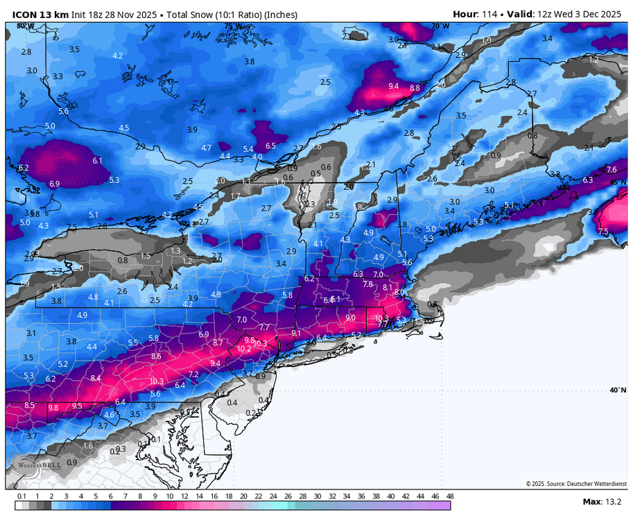
-

First Winter Storm to kickoff 2025-26 Winter season
George001 replied to Baroclinic Zone's topic in New England
Where do you want the low to be? -
The Kluber Met for LOT clearly suffering PWSSD- post traumatic winter storm stress disorder. Whole AFD is basically detailing potential fail modes. Last 5-7 seasons have done damage. Can’t blame him.
-
First Winter Storm to kickoff 2025-26 Winter season
ORH_wxman replied to Baroclinic Zone's topic in New England
Congrats PVD on 18z ICON -
The models make as much sense as the Ravens play calling lol
-
First Winter Storm to kickoff 2025-26 Winter season
powderfreak replied to Baroclinic Zone's topic in New England
Ugh. -
Probably more likely than normal that we see some snow. Very volatile weather pattern though
-
Icon south again basically in line with euro now.
-

December 2025 regional war/obs/disco thread
moneypitmike replied to Torch Tiger's topic in New England
Always reliable back-end snow. -
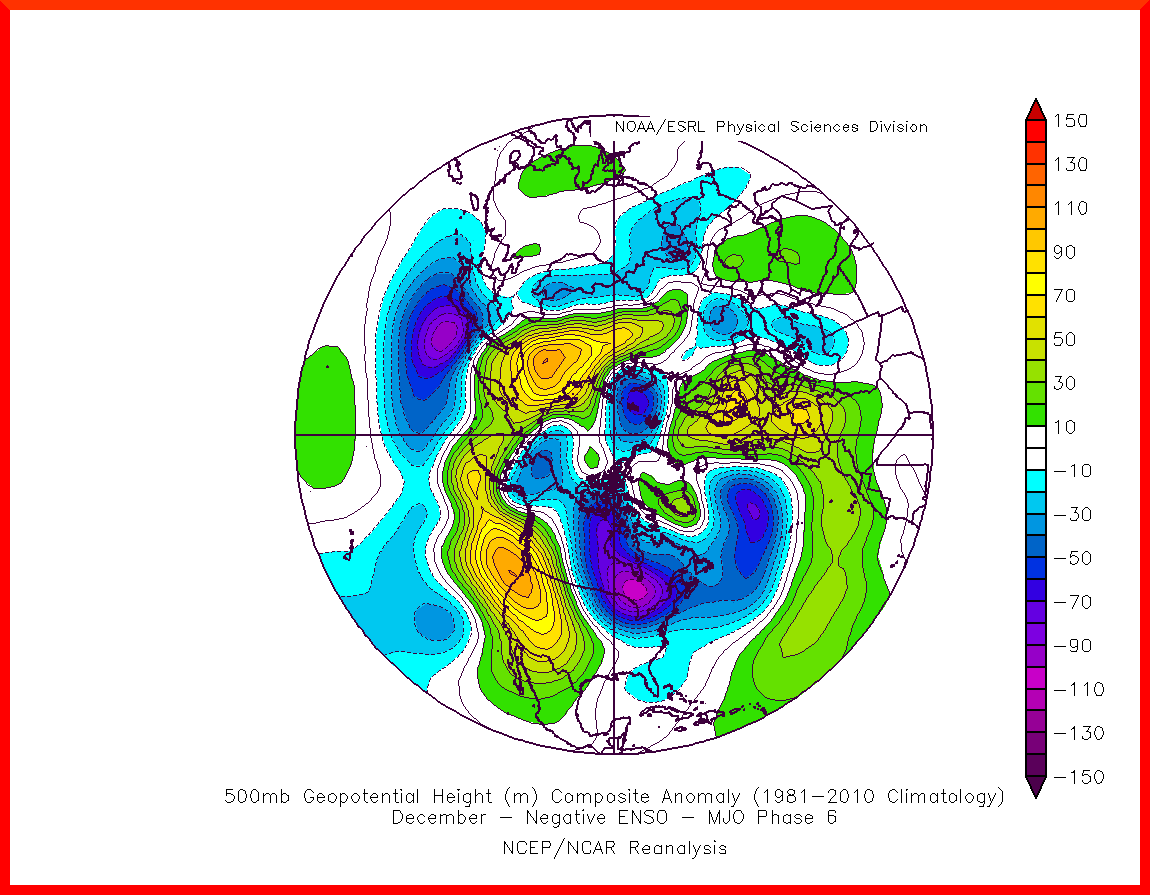
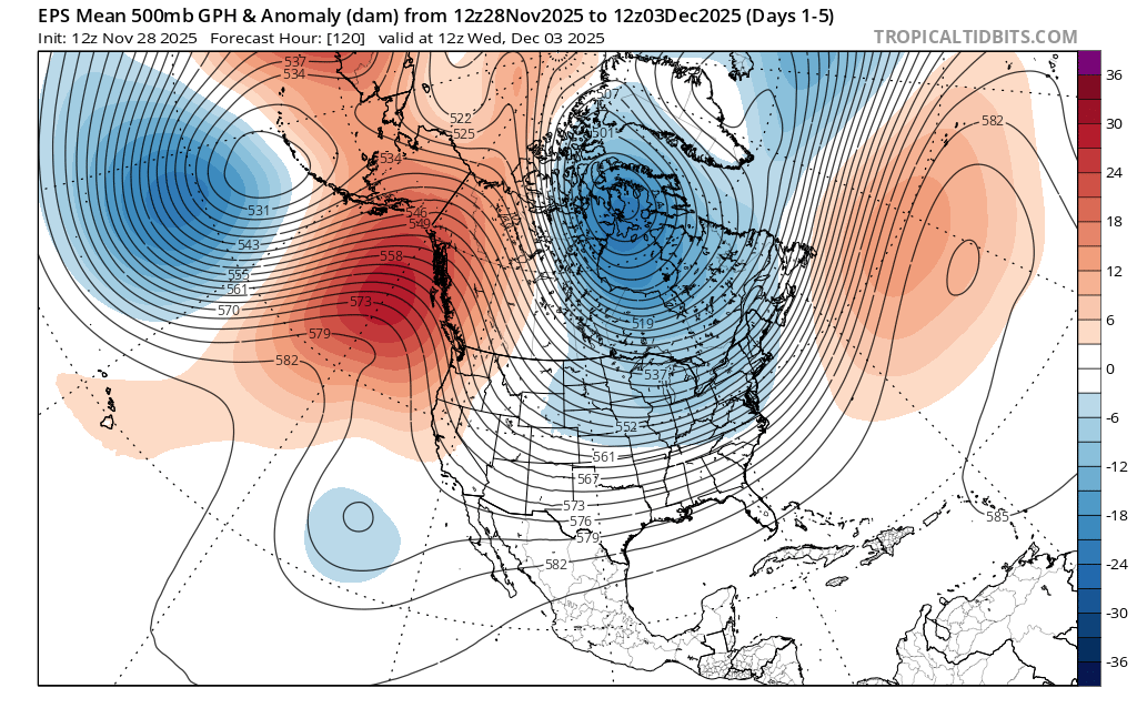
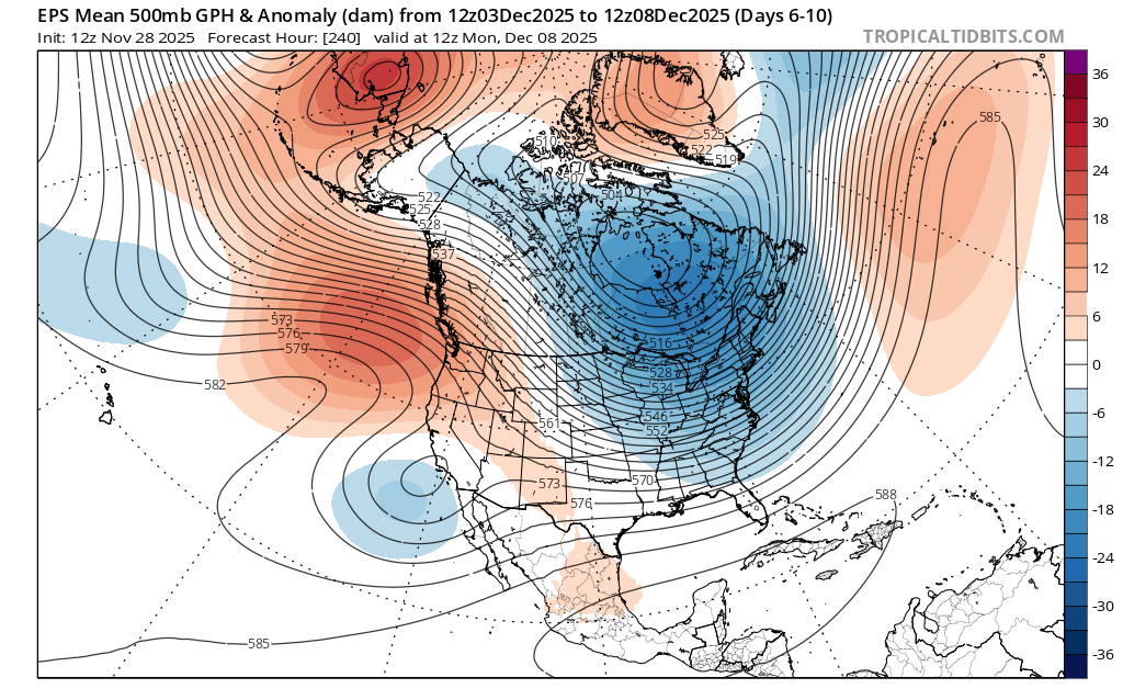
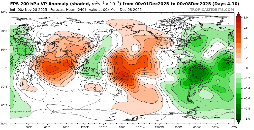
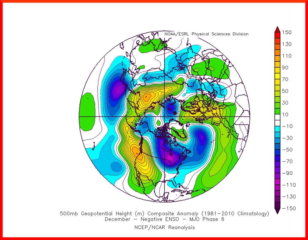
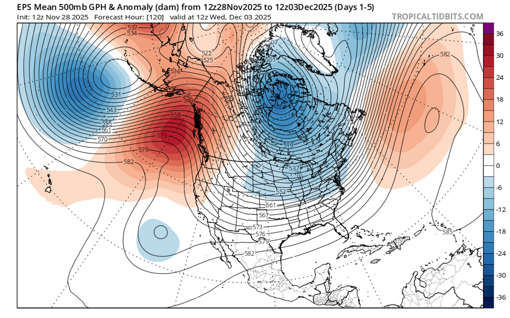
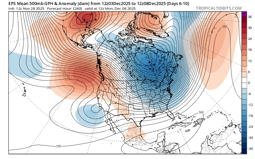
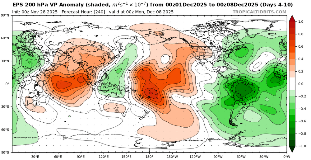
Split forcing between the Maritime Continent and the Western Hemisphere appears to be causing an interference pattern resembling a phase 6 in early December. It could also be why the models have been showing so much volatility between runs over the last week as we head into December. A Northeast Pacific +TNH with a a cold upper low centered near Hudson Bay more closely resembles a phase 6 composite. So trying to guess what composite or pattern we end up with in mid to late December is anyone’s guess at this point. We will just have to let things play out next few weeks to see which area of forcing eventually wins out.
-
You must be hating life.
-

November 2025 general discussions and probable topic derailings ...
Torch Tiger replied to Typhoon Tip's topic in New England
Snowing pretty good. -
First Winter Storm to kickoff 2025-26 Winter season
moneypitmike replied to Baroclinic Zone's topic in New England
Verbatum, this from GYX reads like it would be an 8-hour storm. I thought it was moving more slowly than that. Monday Night Mostly cloudy, with a low around 18. Tuesday Snow likely, mainly after 4pm. Cloudy, with a high near 36. Chance of precipitation is 60%. Tuesday Night Snow likely, mainly before midnight. Mostly cloudy, with a low around 23. Chance of precipitation is 70%. Wednesday Mostly sunny, with a high near 36. -
Just looking at the euro, 925 is actually out of the SW prior to the storm. Gets it to near 1c. Feel like any snow is at the tail end around here when it drops to near freezing.
-

Central PA Fall Discussions and Obs
WmsptWx replied to ChescoWx's topic in Upstate New York/Pennsylvania
US 22 W in Gallitzin is closed. Sounds like a squall blew through and collected a ton of cars. In other news, water is wet, the sky is blue, and the Eagles offense FN STINKS.