All Activity
- Past hour
-
Trying to remember the last time we had such prolonged snow cover. My best guess would be 2013-14.
-

Pittsburgh/Western PA WINTER ‘25/‘26
Rd9108 replied to Burghblizz's topic in Upstate New York/Pennsylvania
https://x.com/i/status/2022373616709472738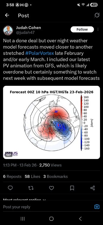
-
SREF trended north lol
-
I thought it was 19. Either way its a hell of a streak. The open fields around me are thinning with some bare spots, but here in the woods still 90% or so with the sunny side out that back showing a few bare spots.
-
because i have a gas station on the corner and can get fresh gas easy.....and i hate to leave gas laying around in cans for weeks on end. also have an electric toro that rips through snow easily; it did so in the last storm. so i'm good, though the tire on my big machine needs replacing. i don't know how the bitter cold affects gas sitting outside in cans, but it probably isn't good.
-
If it's not too late, switch it to Irish Whiskey
-

February 2026 OBS & Discussion
donsutherland1 replied to Stormlover74's topic in New York City Metro
A very good discussion, IMO. It describes what appears to be a reasonable worst-case scenario, although it should be noted that 4 EPS members now show 6" or more. It touches on the lack of phasing, which is a consistent theme given the wide separation of energy and front-running northern piece. -

Pittsburgh/Western PA WINTER ‘25/‘26
colonel717 replied to Burghblizz's topic in Upstate New York/Pennsylvania
Is he saying winter is basically over after 28th with major heat wave likely after we get through phase 3 and possible snow from 20th - 28th? -
Lol. Damn autocorrect. I've written snow so many times, it apparently just figures any word starting with the letter "s" is snow. Should have been stuff.
-
Gift cards and scotch are in the mail for the three shadow mods.
-
When was the last time we had 100% snow cover for 18 straight days?
-

February 2026 OBS & Discussion
CPcantmeasuresnow replied to Stormlover74's topic in New York City Metro
You're talking about the year the Superbowl was in the Meadowlands? Starting game time temp was 48° and 8 hours later, while some were still returning home in the early am, the snow began and the city ended up with over 8 inches. If the snow started 6-8 hours earlier it would have been the most memorable Super bowl for weather of all time. -

Winter 2025-26 Medium/Long Range Discussion
Brian D replied to michsnowfreak's topic in Lakes/Ohio Valley
My town, Two Harbors. -
The northern stream shortwave on the 18z NAM looks a little better positioned to bring precipitation north at 48 hours.
-

Pittsburgh/Western PA WINTER ‘25/‘26
EVLINC64 replied to Burghblizz's topic in Upstate New York/Pennsylvania
The American Storm @BigJoeBastardi · 1h We are about to go into the wildest phase of the MJO you can have in Feb, phase 3. The Feb 5-13 1994 example of what phase 3 can do ( followed by the heat wave right after in 4/5/6) was the greatest case study this year NYC had 2 snowstorms with a total of 22 inches on the ground by the 12th, then was 62 8 days later! This year's target dates in comparison probably 20-28. That not to say 22 inches in NYC. Just to say a lot of wild weather west east centered in the lakes and northeast likely during that phase 3 time -
February 2026 OBS & Discussion
CPcantmeasuresnow replied to Stormlover74's topic in New York City Metro
Who knew. I never noticed it in all these years. Do we have to address you as Sir IrishRob17 now? -
ICON-EPS has about 58% chance of measurable at NYC and 12% 1" liquid. That's a relatively small spread between the extreme outcomes. AIFS-EPS has only 2% chance of 1" of liquid. That continues the theme of a likely miss but small chance of a big hit. Kind of unusual at this short lead time over the past 5 years.
-
2014?
-
 Baja blast, avocado vortex, and now this. This one needs to happen or your LLC is in serious jeopardy.
 -
January 25-26 Winter Storm Potential
Ralph Wiggum replied to Ralph Wiggum's topic in Philadelphia Region
Still have 7" avg of glacier around the yard. This one lingered for quite a while. -
 Listen if that happens I will own ALLLLLLL of it and take my shots with little complaint, hahaha BUT if we are still tracking this by Wed and then it goes poof I'm just gonna sit here giving y'all side eye
 -
E PA/NJ/DE Spring 2026 Obs/Discussion
Ralph Wiggum replied to PhiEaglesfan712's topic in Philadelphia Region
A balmy 33F here, feels like mid June. Refreshing. Still have 7" avg glacier pack around. Sun angle feels nice though. -

Winter Storm Threat *Technical* Discussion. No Op Run PBP or Snow maps
psuhoffman replied to CAPE's topic in Mid Atlantic
The setup for the Feb 24 window is this yea -pna but that’s about as good an Atlantic setup as we can get and later in the season is when this kind of thing can work. The cape wave merges with NS wave rotating around the TPV to form a nice 50/50 coupled with continued ridging in the southwest NAO domain! We would need timing but we get some cold air delivery behind the wave on the 20-21 and with that 50/50 developing it could hold off the SW flow for a few days creating a window of opportunity for something. With the crap pacific that’s what we’re looking for. Windows. We won’t have wall to wall cold in that look. But with the Atlantic and wpo we should get opportunities to time something up.
-

February 2026 OBS & Discussion
WeatherGeek2025 replied to Stormlover74's topic in New York City Metro
still time for this to trend north! i've seen this happen back in the day after a super bowl i forget the year NAM picked it up we got 8 inches in central park. Picked it up Friday, snowed monday -
Operational 12Z GFS and ECMWF came a bit north with the low track, but ensembles still support a low track well south of the area Sunday night into Monday with a low chance for a light accumulating snowfall. Best chance at this time will continue to be across the NYC/NJ metro and Long Island. Right now, have no snow accumulation across the area. However, a reasonable worst case at this time would be an inch or two at the coast and less than an inch inland. Models never phase the two streams for a more amplified system. On occasion, there has been some subtle north/south adjustments. Temperatures during this time are just below normal with highs in the 30s to around 40 and lows in the upper teens inland to the 20s at the coast.


