All Activity
- Past hour
-
 metoprolol succinate side effects: lopressor generic brand names - toprol
 -
where can i buy gabapentin or information about the drug gabapentin what class is gabapentin in https://www.google.nr/url?rct=j&url=https://neuroreliefdirect.com ativan and gabapentin high and http://georgiantheatre.ge/user/wawrqksucu/ what is gabapentin 300 mg capsules [url=https://images.google.nr/url?sa=t&url=https://neuroreliefdirect.com]gabapentin 300 mg wikipedia[/url] where buy gabapentin or [url=http://www.xunlong.tv/en/orangepibbsen/home.php?mod=space&uid=7083024]amitriptyline and gabapentin interactions[/url] gabapentin withdrawal sleep
-

2026-2027 Record-breaking El Nino
GaWx replied to Stormchaserchuck1's topic in Weather Forecasting and Discussion
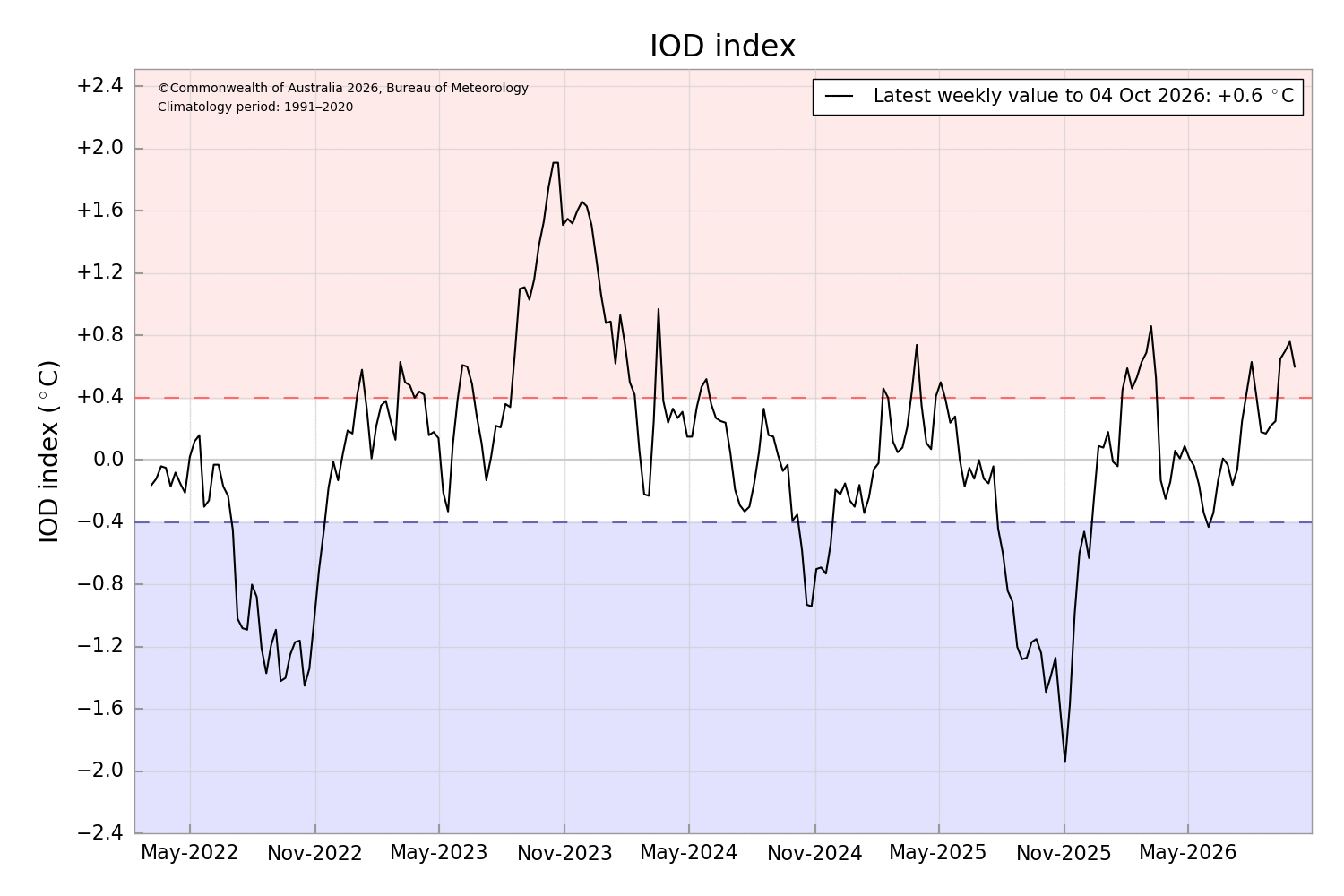
If the IOD guru Adam were still posting (will he ever come back?), I’d now be asking him about the potential very strong +IOD that’s been expected this autumn. It clearly is positive, but it isn’t strong per BoM (at least not yet as it still has til Nov to see if it will jump way up based on the past): As of 10/4/26, the weekly was +0.6. Note that the peak for 2026 so far was actually way back on 3/8/26 (+0.9). Then it fell back to 0 in May, but was then followed by a general rise til now. How does 2026’s +0.6 compare to some past Oct 4ths for Ninos/warm neutral along with 2 Ninas that had an unusual +IOD? 2026 +0.6 2023 +1.8 2019 +1.8 2018 +0.1 2015 +1.1 2014 +0.1 2012 +0.1 2011 +0.6 (mod Nina) 2009 -0.3 2008 +0.2 (weak Nina) —————— As one can see, Nino 2023 and warm neutral 2019 both had triple 2026! Also, Nino 2015 was nearly double. In addition, Nina 2011 was the same! (Aside: Nino 2009 was still negative although it had an unusually very late IOD peak of +0.7 on 1/4/2010.) So, as I said, 2026 isn’t exactly setting the world on fire so far regarding a +IOD. I’ll keep following. Any thoughts? ———————— Weekly IOD 2008+: https://www.bom.gov.au/clim_data/IDCK000072/iod_1.txt?1791781094025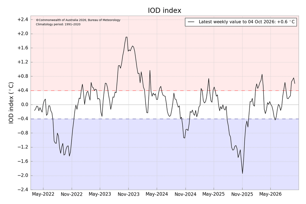
-
https://hydropressdirect.com/# online drugs order
-
3.77 northern Waynesboro By far the highest event here since the final two weeks of September 24. In fact this summer June - August only measured 5.49 here, so this was much needed..
- Today
-
can you take rybelsus and mounjaro together or rybelsus 7 mg para que sirve rybelsus coupon http://coolbuddy.com/newlinks/header.asp?add=http://semaoraldirect.com/ taking semaglutideor https://brueckrachdorf.de/user/itqdhxkjrg/ why does semaglutide cause depression [url=https://images.google.com.do/url?sa=t&url=https://semaoraldirect.com]semaglutide while breastfeeding[/url] how long does it take for rybelsus to start working for weight lossor [url=http://www.orangepi.org/orangepibbsen/home.php?mod=space&uid=7084328]rybelsus and metformin together for weight loss[/url] semaglutide compound
-
https://hydropressdirect.com/# pharmacy online
-
Thank you for your sacrifice!
-
rybelsus for diabetes side effects [url=https://semaoraldirect.com/#]SemaOralDirect[/url] semaglutide generic
-
Well. I am out on the survivor pool. It worked...Ravens win!
-
3.27” for the event with a band rotating slowly over me still
-
It just keeps dumping..probably gonna end up with close to 2” by the time things wind down. Hopefully a nice preview of what’s to come this winter
-
Martinsburg reported 1.25” in the past hour. Now at 3.83” for the day.
-
Stein took a shot to the chin
-
Just heard thunder here. 2.11 inches so far
-
Thundering now
-
Just under 2 inches here. Damp and chilly day. Week ahead looks pretty good, just have to see if there's a blip on Friday.
-
I’m at 2.70, but I agree, those showers in Maryland look to be heading towards the LSV, so maybe we will tack on more overnight.
-
radar suggests the eye remnants are now over Maryland
-
Interesting end to the BTV discussion With a northwesterly flow and sufficient moisture in place, we cannot rule out upslope/mountain snow showers or flurries next weekend, with some minor summit-level accumulations possible. Once the system exits and skies finally clear, this autumn snow against the remaining fall foliage at low elevations could make for a highly picturesque and contrasting view across the high peaks of the Adirondacks and Vermont`s Green Mountains.
-
Loud thunder and lightning with the cell moving in. Should push me past 3”
-

Central PA Autumn 2026
Itstrainingtime replied to canderson's topic in Upstate New York/Pennsylvania
Most rain at my casa in a very long time. Right now I'm at 3.73". Still some bands of convective showers moving up out of MD. Feeling greedy and hoping to reach 4". -
Was a frisky day here. We excel at slight risk days and then do nothing on moderate or high risk days. Most warned storms produced I think there were at least 9 separate tornadoes in the state today
-
Classic tropical airmass, highly efficient and low topped killing the radar estimates. MRMS tells a very different story. Quite a storm for those west of the Bay.
-
3.91