All Activity
- Past hour
-
i hope you feel better soon coastalwx
-
Bro that indeed sucks. I’ve had 2 brushes with it down here, one back in June. Both times i got hit with em just around the neighborhood dog walking. I saw the ticks when I had a ring going, and both times I got it in time with a 2 weeks of doxie. No lyme symptons developed so far since. I think if you can still see the rash and you get drugs you could be alright? Someone else can confirm. I am not a dr.
-
Pretty much the same cure antibiotics so you should be good.
-
Lucky you caught it early it's not a whole heck of a lot of fun.
-

Spring 2025 Med/Long Range Discussion
KakashiHatake2000 replied to John1122's topic in Tennessee Valley
here is what nws morristown was saying yesterday in case if anybody didnt get a chance to see it -
Yeah others tests waiting to come back.
-
Posted in the tropical subforum, but HAFS and Euro really moved west at 12z. Whether that's actually true we'll see, but it would likely bring TS gusts to the coast.
-
That sucks! Better get screened for anaplasmosis also. You’d probably know if you also had babeosis because it feels like malaria.
-
Looks like she’s finally hopping in the car to leave
-
Yeah on it now. Don't really feel any effects from it other than a rash on my thigh where I assume it happened. Never knew and no idea how I got it.
-

Hurricane Erin: 140 MPH - 935 mb - NW @ 12
jm1220 replied to BarryStantonGBP's topic in Tropical Headquarters
Also, not saying this to you or anyone specifically but don’t quote him-that will cut down on the posts of his you see as well. I agree that he should put the phone or keyboard away when he’s on his tenth pint in Ibiza or wherever. -
Nasty morning, slightly better now with some sun
-

Hurricane Erin: 140 MPH - 935 mb - NW @ 12
WEATHER53 replied to BarryStantonGBP's topic in Tropical Headquarters
It’s 20 degrees cooler around DC today with a solid push from the north. Will this have an effect on Erin ? -
c'mon you can't be feeling a chill at your age lol
-
Damn..are you able to zap it with antibiotics?
-

Hurricane Erin: 140 MPH - 935 mb - NW @ 12
Wannabehippie replied to BarryStantonGBP's topic in Tropical Headquarters
2:00 PM EDT Mon Aug 18 Location: 23.5°N 71.1°W Moving: WNW at 10 mph Min pressure: 937 mb Max sustained: 140 mph -
Feels like Christmas only less humid.
-
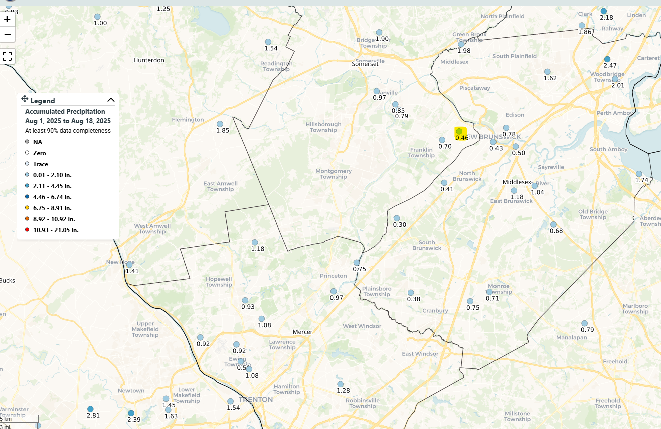
 Yeah. I'm at 0.46" month-to-date (actually back to 7/27). Among the driest in the state (at least for CoCoRaHS). https://maps.cocorahs.org/?maptype=precip&units=us&base=std&cp=BluYlwRed&datetype=mtd&displayna=0&dc=0.9&key=dynamic&overlays=state,county&bbox=-76.86859130859376,39.65645604812829,-72.25433349609376,41.44066745847661
-
Well Lyme Phil got me. Time for all of us to nuke everything in site until we grow a third arm. Fuck these things.
-
65/49 This is ideal weather when watching an early October Pats game.
-

Hurricane Erin: 140 MPH - 935 mb - NW @ 12
TPAwx replied to BarryStantonGBP's topic in Tropical Headquarters
Thanks for taking action. FYI for others. I had placed BGP on ignore but continued to see their posts. Had to manually toggle off visibility option in my settings to suppress posts and other activity. -
This thing is one bad turn away from having an few outer rainbands scrape portions of the eastern seaboard. At the very least, this will be a decent surf/tidal event. The wording is warranted, IMO.
-

NEW DISTURBANCE: Central Tropical Atlantic (0/50)
WxWatcher007 replied to BarryStantonGBP's topic in Tropical Headquarters
Odds up at 2pm Tropical Weather Outlook NWS National Hurricane Center Miami FL 200 PM EDT Mon Aug 18 2025 For the North Atlantic...Caribbean Sea and the Gulf of America: Active Systems: The National Hurricane Center is issuing advisories on Hurricane Erin, located near the Southeast Bahamas. Tropical Atlantic: A tropical wave located over the eastern tropical Atlantic is producing limited disorganized showers and thunderstorms. Environmental conditions appear conducive for gradual development of this system, and a tropical depression could form toward the end of the week. This system should move westward to west-northwestward at about 20 mph across the central tropical Atlantic and approach the vicinity of the Leeward Islands on Friday. * Formation chance through 48 hours...low...10 percent. * Formation chance through 7 days...medium...60 percent. $$ Forecaster Roberts -

Hurricane Erin: 140 MPH - 935 mb - NW @ 12
Scott747 replied to BarryStantonGBP's topic in Tropical Headquarters
Plenty of his posts have been either deleted or edited recently. For the most part he has taken the hint after some advice behind the scenes. If a poster is continuing to be annoying, either put them on ignore or report them. -
Hurricane Erin: 140 MPH - 935 mb - NW @ 12
WxWatcher007 replied to BarryStantonGBP's topic in Tropical Headquarters
Count me in this group. Erin did mount a bit of a comeback, but the structural changes and shear has taken a toll. Still a dangerous storm to be sure, but just entering a new phase of its life cycle as it turns north and expands dramatically. Here's the last 10 hours on IR. Perhaps of note (or not), both the 12z HAFS and Euro pull this significantly closer to the Outer Banks. There have been some modeling head fakes, hence my skepticism, but as we know Erin has been pulling more west at times. Flooding will be the major issue there, but it looks like a TS watch may be justified later today. Even though it won't be a direct hit, I hope Outer Banks folks are taking this seriously.


.thumb.png.4150b06c63a21f61052e47a612bf1818.png)