All Activity
- Past hour
-
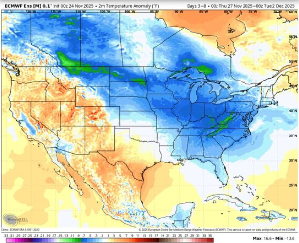
And so is the tropics. Same run tries to brew a hurricane in the Caribbean in fantasy range.
-

2025-2026 ENSO
40/70 Benchmark replied to 40/70 Benchmark's topic in Weather Forecasting and Discussion
You never answered my question on FB...How did you do in December 2000, 2007 and 2008? -
Classic Nina December is better for points south . It gets tougher once you get to February .
-

2025-2026 ENSO
brooklynwx99 replied to 40/70 Benchmark's topic in Weather Forecasting and Discussion
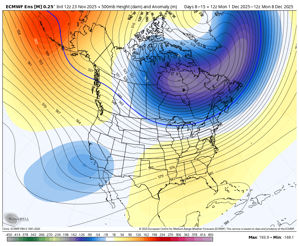
the TPV elongating like that into SE Canada should present opportunities for overrunning -
Decent severe weather threat for much of east Texas into LA/MS this afternoon into tonight. Could see a few sky noodles.
-

November 2025 general discussions and probable topic derailings ...
dryslot replied to Typhoon Tip's topic in New England
Its lid? -
Also pretty classic climo. All the places mentioned is typical for this time of the year winter weather wise. The further N you are, the better chances you have.
-

Central PA Fall Discussions and Obs
pasnownut replied to ChescoWx's topic in Upstate New York/Pennsylvania
Last year i did one on my OK Joes stick/offset smoker along side of my Green Mtn pellet smoker. Fun to play/learn w/ both. Pellet is MUCH easier, but offset/stick is MUCH smokier. If you have a pellet smoker, get a heat blanket for it....its a game changer in cold months. Truth told, i now keep it on all year. Pellet saver as well. -

November 2025 general discussions and probable topic derailings ...
MJO812 replied to Typhoon Tip's topic in New England
Not at all. The progression is still there on the MJO and the models . We should be in phase 8 by mid December. Also , the models keep showing warmth in the long range until it gets closer and it cools off. -
WINTER’S BACK ON THE MENU BOYS
-
Yeah, sucks for CPK. Vast majority of the subforum has had a 4" snowfall. But here that is all you will read about.
-
For december, one would definitely want to be north of I-80. Even here, probably still dealing with rain from time to time.

-

November 2025 general discussions and probable topic derailings ...
ineedsnow replied to Typhoon Tip's topic in New England
Thats one of the places I eventually want to end up. Perfect for snow and cold with cooler Summers.. my area will do for now though -
Tanning oil out for TCC
-
You can tell Tony is panicking because he keeps emphatically questioning anyone who isn't sold on a wintry December.
-
86-87 was one of those years when the 45-“50” amounts went just to our south with the El Niño that year. Data for October 1, 1986 through April 30, 1987 Click column heading to sort ascending, click again to sort descending. SUSSEX 1 NW COOP 70.0 HIGH POINT PARK COOP 53.9 LAKEHURST NAS WBAN 53.3 ESTELL MANOR COOP 48.1 NEW BRUNSWICK 3 SE COOP 47.3 New Brunswick Area ThreadEx 47.3 POTTERSVILLE 2 NNW COOP 46.1 OAK RIDGE RESERVOIR COOP 45.5 INDIAN MILLS 2 W COOP 45.4 HIGHTSTOWN 2 W COOP 44.8
-
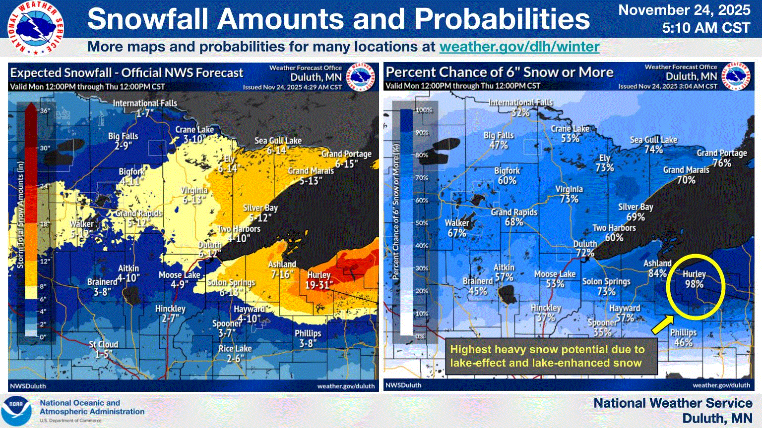
NWS Duluth getting frisky with this one. Here on the shoreline, expecting lower guidance 3-5". But the higher terrain could do well here. The bulk of the precip hitting at night when temps are a little cooler, coupled with colder air mixing in will help with this one. Ground will cool off fast, as well.

-

November 2025 general discussions and probable topic derailings ...
CoastalWx replied to Typhoon Tip's topic in New England
First week will be AN I think. Maybe after the 5th it cools off. We knew. -

Central PA Fall Discussions and Obs
pawatch replied to ChescoWx's topic in Upstate New York/Pennsylvania
Usually do 6-8 turkeys every year. Taking the year off this year. The wind really can make it difficult to smoke. Especially 30 mph wind gusts. -
This is amazing. Even putting the titles on each storm reference represents a lot of work, and is super helpful. High regards to all involved - great job!
-
 With a post like that.. what do you think lol
 -
Was the theme of the 80's as well despite some very cold snaps-storm track was either well out to sea or inland.
-
You guys need to smoke some weed
-
Also an emphasis on the name, "December LONG RANGE Discussion." A LOT can still change because we are in the LONG RANGE!! Especially when the pattern is so volatile and uncertain. People need to stop canceling winter so quickly
-
November 2025 general discussions and probable topic derailings ...
CoastalWx replied to Typhoon Tip's topic in New England
Useless since ensembles cover it. Flipped to what?


.thumb.png.991e09c19c25af7391ed569a205a5136.png)

