All Activity
- Past hour
-
Severe Weather Statement National Weather Service Huntsville AL 850 PM CDT Tue May 20 2025 ALC049-071-210230- /O.CON.KHUN.TO.W.0051.000000T0000Z-250521T0230Z/ Jackson AL-DeKalb AL- 850 PM CDT Tue May 20 2025 ...A TORNADO WARNING REMAINS IN EFFECT UNTIL 930 PM CDT FOR SOUTHEASTERN JACKSON AND CENTRAL DEKALB COUNTIES... At 850 PM CDT, a confirmed tornado was located over Section, or 7 miles northwest of Rainsville, moving east at 35 mph. HAZARD...Damaging tornado and half dollar size hail. SOURCE...Broadcast media confirmed tornado. IMPACT...Flying debris will be dangerous to those caught without shelter. Mobile homes will be damaged or destroyed. Damage to roofs, windows, and vehicles will occur. Tree damage is likely. This tornado will be near... Sylvania, Powell, and Rainsville around 855 PM CDT. Henagar around 900 PM CDT. Fort Payne around 910 PM CDT. Other locations impacted by this tornadic thunderstorm include Dutton, Langston, Mentone, Desoto State Park, Valley Head, Hammondville, and Pine Ridge. PRECAUTIONARY/PREPAREDNESS ACTIONS... To repeat, a tornado is on the ground. TAKE COVER NOW! Move to a basement or an interior room on the lowest floor of a sturdy building. Avoid windows. If you are outdoors, in a mobile home, or in a vehicle, move to the closest substantial shelter and protect yourself from flying debris. && LAT...LON 3451 8553 3450 8555 3450 8556 3449 8556 3448 8558 3447 8557 3447 8558 3443 8558 3450 8609 3467 8607 3469 8555 3454 8551 TIME...MOT...LOC 0150Z 270DEG 30KT 3457 8593 TORNADO...OBSERVED MAX HAIL SIZE...1.25 IN $$
-
I loved this hot wx, even in the early 80's kindergarten. Never complained, was perfect!
-
I'm definitely in shape lol I fucking hate anything above 85 , if it's dry and breezy it's awesome but stagnant hot city air is terrible
-
I know not of whom you speak.
-
I expect the 798hr cfs from you in July.
-
Meh it's almost time for the heat and dews.. but let's not forget in 73 days it's August 1st and I'll be posting every long range GFS cold front I see
-
Yeah it's a weird pattern. Tried to wade through the prognostic discussion but got a popsicle headache. It's probably one lonely meteorologist in his garage in College Park these days.
-
I actually felt some humidity this evening, but it was the right amount and calm wind. Three ball weather.
-
Severe Weather Statement National Weather Service Huntsville AL 822 PM CDT Tue May 20 2025 ALC049-071-095-210145- /O.CON.KHUN.TO.W.0048.000000T0000Z-250521T0145Z/ Marshall AL-Jackson AL-DeKalb AL- 822 PM CDT Tue May 20 2025 ...A TORNADO WARNING REMAINS IN EFFECT UNTIL 845 PM CDT FOR NORTHEASTERN MARSHALL...SOUTHERN JACKSON AND CENTRAL DEKALB COUNTIES... At 822 PM CDT, a confirmed tornado was located over Section, or 7 miles southeast of Scottsboro, moving east at 35 mph. HAZARD...Damaging tornado and golf ball size hail. SOURCE...Emergency management confirmed tornado. IMPACT...Flying debris will be dangerous to those caught without shelter. Mobile homes will be damaged or destroyed. Damage to roofs, windows, and vehicles will occur. Tree damage is likely. This tornado will be near... Rainsville, Henagar, Sylvania, and Powell around 830 PM CDT. Other locations impacted by this tornadic thunderstorm include Dutton, Langston, Paint Rock, and Pine Ridge. PRECAUTIONARY/PREPAREDNESS ACTIONS... To repeat, a tornado is on the ground. TAKE COVER NOW! Move to a basement or an interior room on the lowest floor of a sturdy building. Avoid windows. If you are outdoors, in a mobile home, or in a vehicle, move to the closest substantial shelter and protect yourself from flying debris. && LAT...LON 3452 8633 3456 8631 3457 8633 3458 8630 3459 8630 3460 8633 3466 8633 3470 8573 3445 8572 TIME...MOT...LOC 0122Z 268DEG 32KT 3459 8595 TORNADO...OBSERVED MAX HAIL SIZE...1.75 IN $$ KTW
-
The NWS Huntsville, Hytop NWS radar is down due to the severe weather. Any storms will have to be tracked via composite data from the NWS Birmingham, NWS Atlanta/Peachtree City radars.
-
That end of May early June period looks more promising. Far enough out that I don't trust it yet but most modeling showing a heat signal. Not sure of the duration tho'...
-
I just want it warm … with light lingering breezes extending into the evenings, and the promise of 64 at dawn going to the mid 80s the next day, and the day after that.
-
Yeah I’m ready for Kevin to be trolling ACATT daily.
-
Can’t wait for the heat and dews
-
They haven't gotten cooler though. Maybe they're warming less than winter but still warming
-
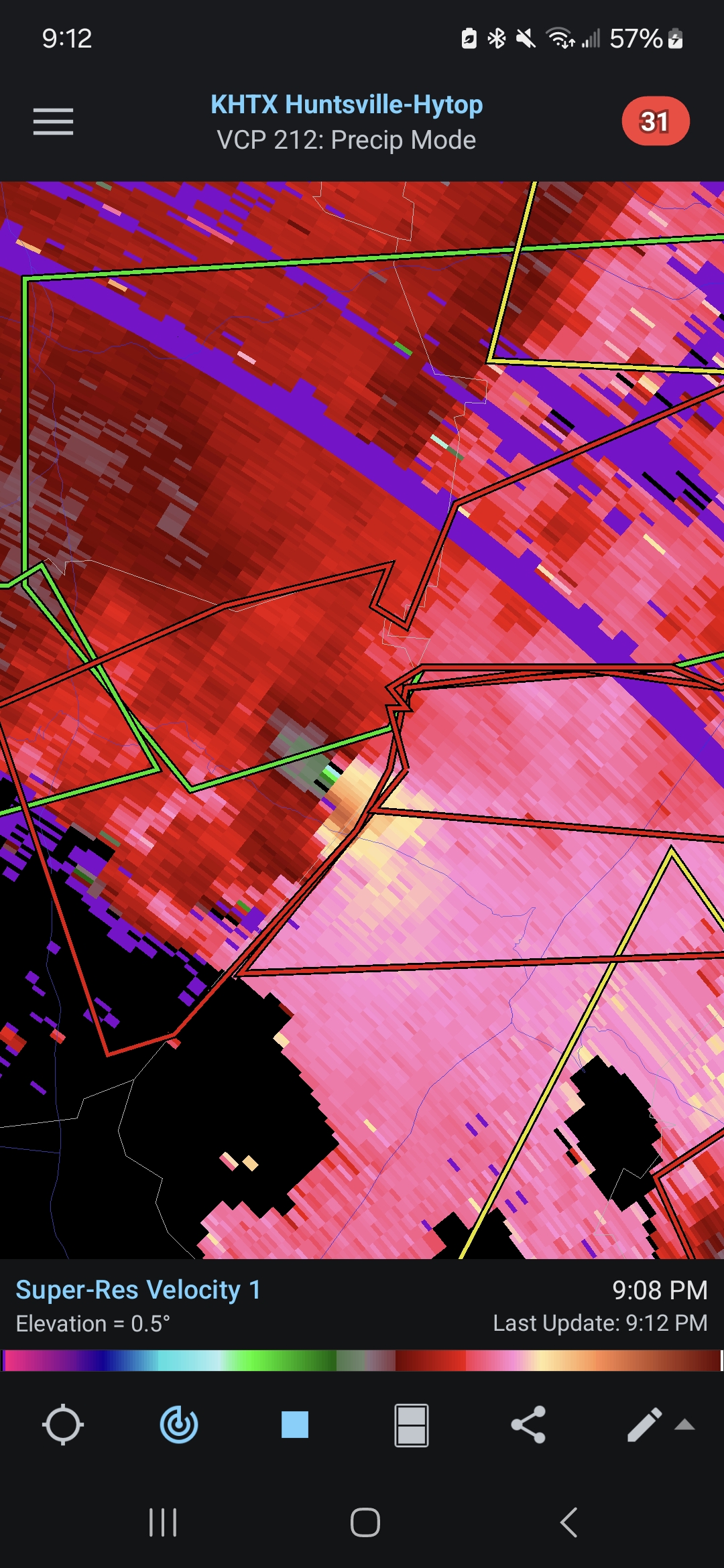
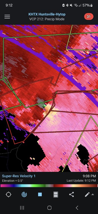
The cell east of Spencer TN had a pretty intense couplet (though not as impressive in the last few scans) and a weak TDS.
- Today
-
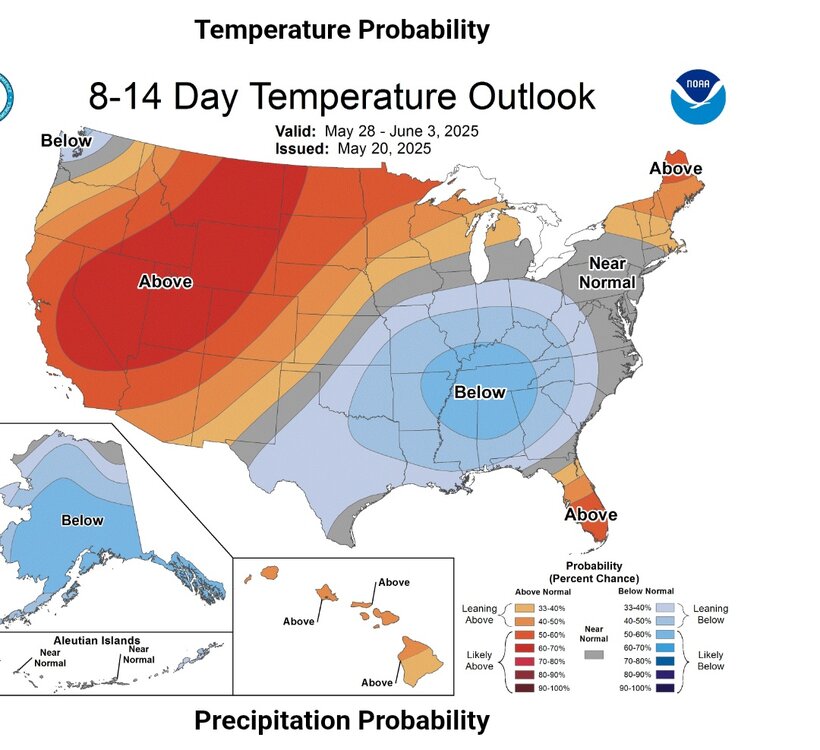
Thanks to its warm start, May will wind up near normal to perhaps slightly below normal.
-
Tornado Warning ALC071-089-103-210130- /O.NEW.KHUN.TO.W.0049.250521T0104Z-250521T0130Z/ BULLETIN - EAS ACTIVATION REQUESTED Tornado Warning National Weather Service Huntsville AL 804 PM CDT Tue May 20 2025 The National Weather Service in Huntsville Alabama has issued a * Tornado Warning for... Southwestern Jackson County in northeastern Alabama... Southeastern Madison County in north central Alabama... Northeastern Morgan County in north central Alabama... * Until 830 PM CDT. * At 804 PM CDT, a severe thunderstorm capable of producing a tornado was located near Redstone Arsenal, moving east at 45 mph. HAZARD...Tornado and quarter size hail. SOURCE...Radar indicated rotation. IMPACT...Flying debris will be dangerous to those caught without shelter. Mobile homes will be damaged or destroyed. Damage to roofs, windows, and vehicles will occur. Tree damage is likely. * This dangerous storm will be near... Owens Cross Roads and Huntsville around 810 PM CDT. Woodville around 820 PM CDT. Other locations impacted by this tornadic thunderstorm include Paint Rock, Garth, Hampton Cove, Laceys Spring, Farley, and Whitesburg. PRECAUTIONARY/PREPAREDNESS ACTIONS... TAKE COVER NOW! Move to a basement or an interior room on the lowest floor of a sturdy building. Avoid windows. If you are outdoors, in a mobile home, or in a vehicle, move to the closest substantial shelter and protect yourself from flying debris. && LAT...LON 3466 8628 3458 8631 3457 8633 3456 8631 3451 8633 3452 8639 3450 8639 3449 8642 3451 8654 3454 8655 3451 8656 3453 8667 3471 8667 3474 8627 TIME...MOT...LOC 0104Z 266DEG 38KT 3459 8659 TORNADO...RADAR INDICATED MAX HAIL SIZE...1.00 IN $$ GH
-
Two separate circulations in this other two supercells are near Lacey Springs and another one near Owens Crossroads respectively that are clearly looking very ominous and like both could put down tornadoes
-
New tornado debris signature and confirmed by local Jackson County 911 that it is on the ground Severe Weather Statement National Weather Service Huntsville AL 802 PM CDT Tue May 20 2025 ALC049-071-095-210145- /O.CON.KHUN.TO.W.0048.000000T0000Z-250521T0145Z/ Marshall AL-Jackson AL-DeKalb AL- 802 PM CDT Tue May 20 2025 ...A TORNADO WARNING REMAINS IN EFFECT UNTIL 845 PM CDT FOR NORTHEASTERN MARSHALL...SOUTHERN JACKSON AND CENTRAL DEKALB COUNTIES... At 801 PM CDT, a confirmed tornado was located near Grant, or 9 miles southwest of Scottsboro, moving east at 40 mph. HAZARD...Damaging tornado and ping pong ball size hail. SOURCE...Emergency management confirmed tornado. IMPACT...Flying debris will be dangerous to those caught without shelter. Mobile homes will be damaged or destroyed. Damage to roofs, windows, and vehicles will occur. Tree damage is likely. This tornado will be near... Scottsboro around 805 PM CDT. Section around 810 PM CDT. Powell around 820 PM CDT. Sylvania around 825 PM CDT. Henagar and Rainsville around 830 PM CDT. Other locations impacted by this tornadic thunderstorm include Dutton, Langston, Paint Rock, and Pine Ridge. PRECAUTIONARY/PREPAREDNESS ACTIONS... To repeat, a tornado is on the ground. TAKE COVER NOW! Move to a basement or an interior room on the lowest floor of a sturdy building. Avoid windows. If you are outdoors, in a mobile home, or in a vehicle, move to the closest substantial shelter and protect yourself from flying debris. && LAT...LON 3452 8633 3456 8631 3457 8633 3458 8630 3459 8630 3460 8633 3466 8633 3470 8573 3445 8572 TIME...MOT...LOC 0101Z 267DEG 34KT 3458 8618 TORNADO...OBSERVED MAX HAIL SIZE...1.50 IN $$ KTW
-

2025 Spring/Summer Mountain Thread
wncsnow replied to Maggie Valley Steve's topic in Southeastern States
Just had some small hail in a non warned storm in McDowell -
See my post above. Apparently it works on all children.
-
Funny how this run of cold weather quiets the all-hot all the time boyz. You just know It would be non-stop talk about installs or how hot it is in Pelham, Swansea , Seekonk or some other far-flung delivery location.
-
My classroom gets disgusting when it’s hot and humid. The kids get cranky. In cool/dreary weather they act a bit calmer.
-
I thought you were a teacher? How does It make your job easier? Canceled field day?


.thumb.png.4150b06c63a21f61052e47a612bf1818.png)