All Activity
- Past hour
-
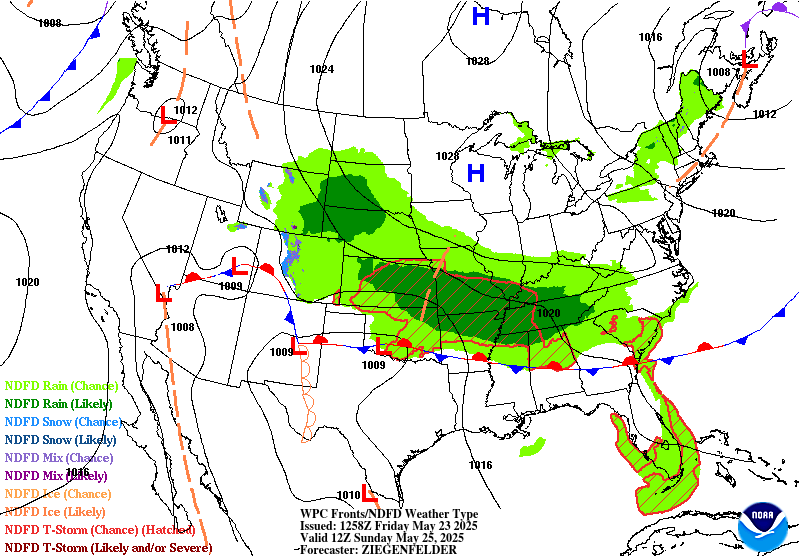
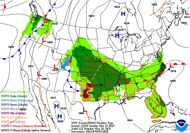
Hmmm, from this morning LWX AFD The end of the week into this weekend is starting to look more interesting with each run of model guidance. Those two upper-lows may try to phase into one over the eastern CONUS during this timeframe. Should this occur, a powerful surface low could bring some impactful weather to the region. Lots of uncertainty at this point however, so going to keep it vague for now. Just know that this is a period to watch this week.
-
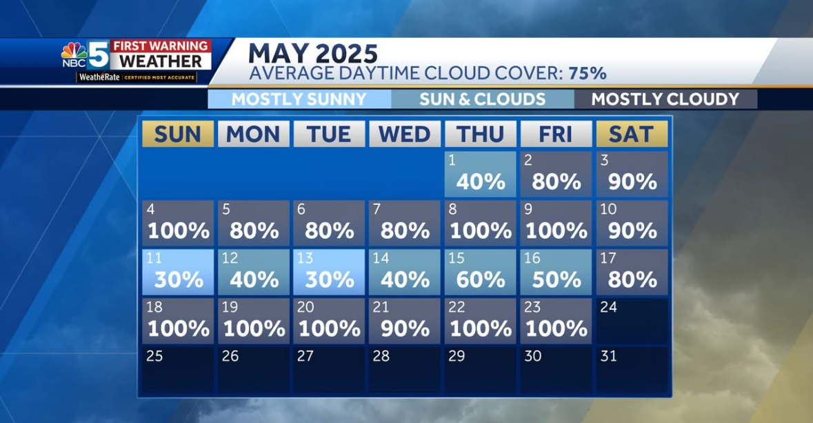
It's been a cloudy morning here with a few showers.. tomorrow should be better for most
-
Hard to believe yesterday was nicer than today . Was not on anyone’s bingo card
-
Im at 54, better than the 40s we had last week, I remember Memorial Day being a good beach day in years past.
-
isn't CP all time high 106 from the 1930's? 112-114 wow. Has the earth warmed that much ? With the marine influence on the coast I doubt NYC temps could ever reach that high. The hottest day I ever remember was July 15th 1995. 102 with dewpoints near 80 could kill you. And it did for many of the old in Chicago.
-
So-so call on this forecast. Trough swung through the Lakes, HP took over before LP from the SW could move into the sub. Looks like LP will move along the OHRV on Tues.
-
All our summer heat over the last decade had come with onshore flow and record high dew points. This is a result of the big ridge setting up east of New England. So the 100° heat has been mostly found over NJ with only occasional instances into Queens. It has also been a pretty rainy summer pattern. From 2010 to 2013 the ridge was to our west over the Great Lakes. So we got frequent westerly flow downsloping events. Even though the dry patterns were modest compared to earlier times, we still maxed out at 108°. Parts of the Pacific Northwest had highs 6° above the all-time levels back in 2021. The result of the much warmer climate in the 2020s and the historic droughts out West. So if this area ever saw a 1960s style drought with 2020s temperatures and westerly flow, then the max temperature potential would probably be 112° to 114°. The good news is that it’s very difficult to meet these conditions in this new climate. Since it’s uncertain how well our power grid would function with widespread temperatures that high.
-
This sums it up.

-
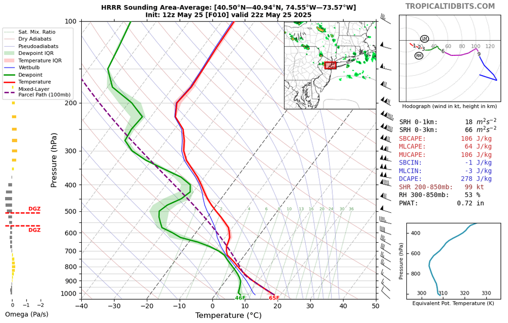
just enough low level cape to produce barbecue ruiners
-
It runs through October 26th.
-
Yes. Absolutely beautiful.
-
it's only 50% cloudy here but the sun just happens to be covered. if the winds stay up they will blow the clouds away
-
FPizz and I roast while and relief storms dodge us. I'd like my pool to warm up soon without using the heater all day, lol.
-
JFK better hit at least 105 in that pattern.
-
1966 and 1983 had absolutely amazing summers even with spring temperatures never making it out of the 70s.
-
Yes-- and number1 and number 2 on that average high temperature list had VERY hot summers. From that chart it can be seen that this spring is very similar to last year's On the top chart, it's amazing that 1983 had the lowest high since it was the hottest summer here until 2010.... 1983 must have had an extremely rainy spring to keep the highest spring temperature down at 75. 1966 was our hottest summer before 1983 with 100+ degree temperatures starting in June and continuing into July so it's amazing to see its highest spring temperature down at 79 too.
-
Our baselines are high. I worry what will happen when we get a real hot pattern set up. We have seen records shattered by huge margins worldwide when a hot pattern sets up over them. Our region hasn't really had that happen in several years. I can see the Fpizz to Newark corridor getting to 110F with the right pattern.
-

-
I got absolutely destroyed by allergies yesterday after doing yard work for most of the day. Rain didn’t sweep out all the pollen apparently lol
-
Mostly cloudy here now lol But I went out at 730AM it was beautiful. Maybe the clouds will break up.
- Today
-
Pretty wild how JFK has had the 7 lowest spring high temperature at only 82° while the average high temperature has been 3rd warmest. Time Series Summary for JFK INTERNATIONAL AIRPORT, NY - Mar through May Click column heading to sort ascending, click again to sort descending warmest spring temperature 1 1983 75 0 - 1967 75 0 3 1968 78 0 - 1958 78 0 4 2008 79 0 - 1984 79 0 - 1966 79 0 5 2005 80 0 6 1961 81 0 - 1950 81 0 7 2025 82 7 - 2004 82 0 - 1997 82 0 - 1982 82 0 - 1972 82 0 - 1971 82 0 - 1951 82 Time Series Summary for JFK INTERNATIONAL AIRPORT, NY Click column heading to sort ascending, click again to sort descending average spring high temperature 1 2010 64.0 0 2 2012 63.1 0 3 2025 62.6 7 4 2024 62.5 6 - 1985 62.5 0 5 1991 61.8 0 6 1986 61.3 0
-
-
A gorgeous cool evening for the Newtown Heritage Festival. Lots of festival-goers in fleece and blankets for the fireworks last night. Incredible for this time of year. Easily, the best prolonged stretch of weather i have ever seen this time of year. Yesterday afternoon when I was grilling I went and sat down in the sun and the warmth in the cool breeze was just so relaxing. This must be what summer feels like in central Canada. Delightful.
-
Weren't those 15-20 minutes magnificent though? Cloudy, breezy, and 56 here currently.
-
68 here yesterday was pretty good when the sun was out, today might be close to normal here around 70.


.thumb.png.4150b06c63a21f61052e47a612bf1818.png)