
All Activity
- Past hour
-
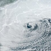
October Comes Early: Late September Multi-Hazard Hybrid Storm
bristolri_wx replied to WxWatcher007's topic in New England
Didn’t the 1950 storm happen in November? Seems like an apples to oranges comparison. Not sure if this type of record keeping exists but would like to see where this storm ranks in terms of September nor’easters. Probably hard to track that given the number or remnant tropical, subtropical, and hybrid systems there are this time of year. I feel like most official forecasts were within reason. It’s the social media clickbait posting 90 MPH gusts on the RRFS-A that kind of leak into the “hype” narrative here… Will be a memorable storm for many just based on rainfall. -

October Comes Early: Late September Multi-Hazard Hybrid Storm
WinterWolf replied to WxWatcher007's topic in New England
Not to often when Hartford blows away(no pun intended…ok maybe a little bit) New Haven. -
October Comes Early: Late September Multi-Hazard Hybrid Storm
WinterWolf replied to WxWatcher007's topic in New England
Nah…no big deal..meh! -
This weather sux imho.
-

October Comes Early: Late September Multi-Hazard Hybrid Storm
psv88 replied to WxWatcher007's topic in New England
Que? -

Strong Nor'Easter/Hybrid Storm Late September 2026
GaWx replied to Rjay's topic in New York City Metro
Thanks. Glad it wasn’t that bad there then. Between Fri and Sun, the delays at LGA were shortest on Sat due largely to the normal fewer scheduled flights that day allowing for them to handle the use of just one runway. But today’s avg delay is still getting longer with it 2 hrs, 19 min, at last report though that’s still not as bad as the ~2 hrs, 45 min of late Fri: Due to WEATHER / WIND, there is a Traffic Management Program in effect for traffic arriving La Guardia Airport, New York, NY (LGA). This is causing some arriving flights to be delayed an average of 2 hours and 19 minutes. To see if you may be affected, select your departure airport and check "Delays by Destination". Delays by Destination: Due to WEATHER / WIND, departure traffic destined to La Guardia Airport, New York, NY (LGA) is currently experiencing delays averaging 2 hours and 19 minutes. General Departure Delays: Due to WX:Wind, traffic is experiencing Gate Hold and Taxi delays between 1 hour and 1 minute and 1 hour and 15 minutes in length and increasing. -
Strong Nor'Easter/Hybrid Storm Late September 2026
psv88 replied to Rjay's topic in New York City Metro
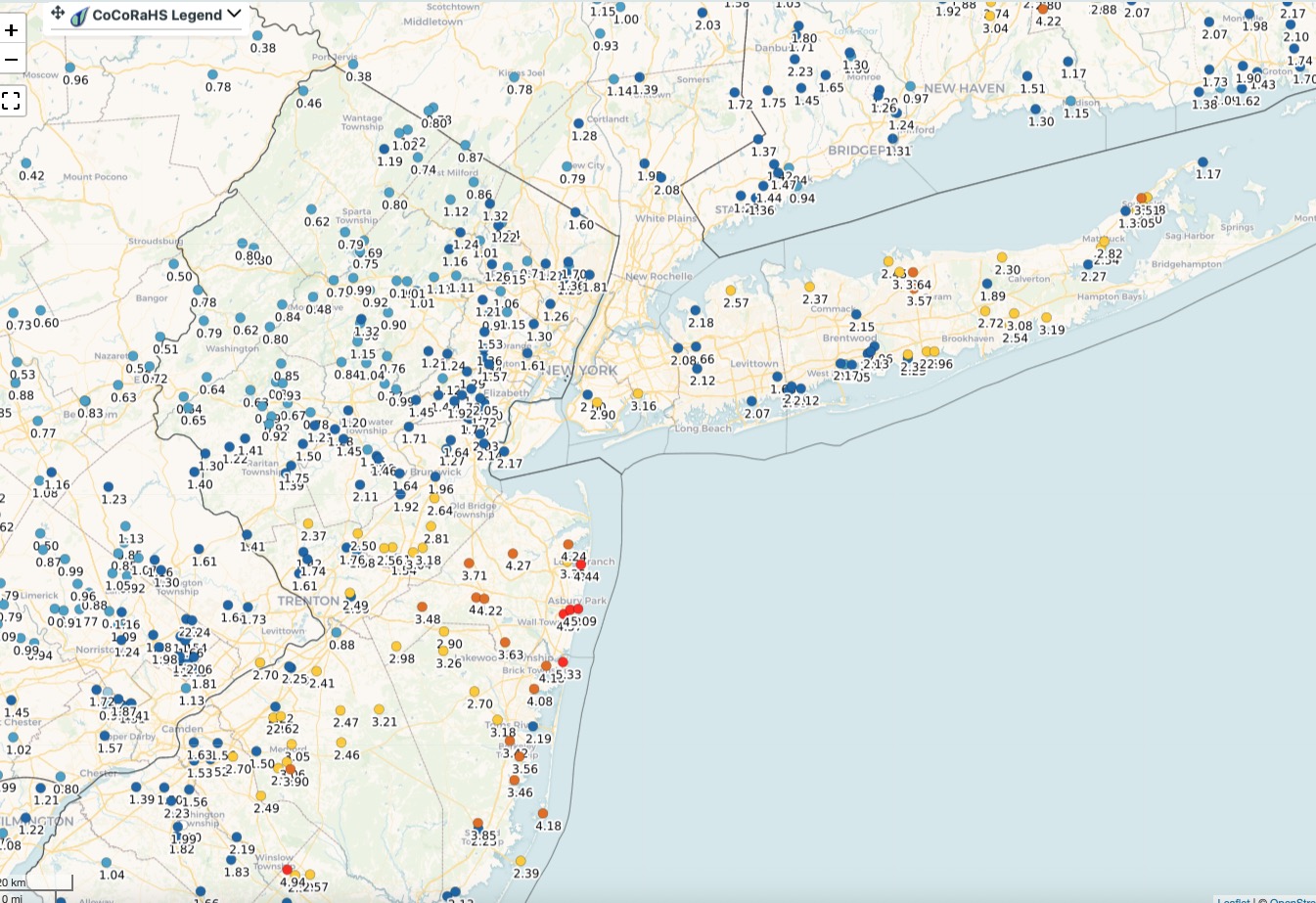
2.74” storm total and winds topped out mid 50s. Pretty standard nor’easter for Long Island. -

Strong Nor'Easter/Hybrid Storm Late September 2026
MANDA replied to Rjay's topic in New York City Metro
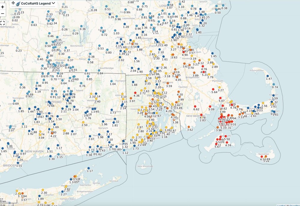
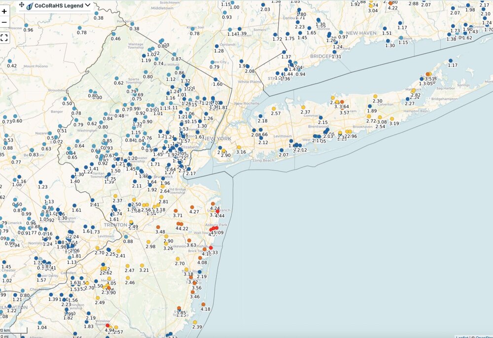
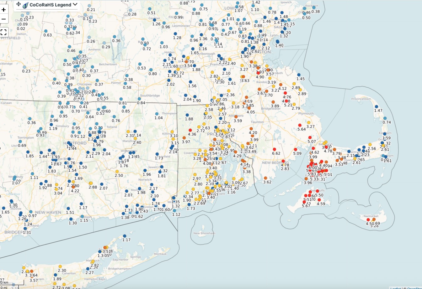
Event total rainfall here so far .99". Very windy overnight. Estimating gusts to 40 mph. Winds blew hard all night. Lots of leaves, twigs and small branches down in the yard. Numerous power outages in my immediate area. JCPL reporting close to 46,000 customers out across their service areas in NJ. Southeast New England and coastal Jersey have received the heaviest total rainfall. Forecasts for a high impact coastal storm worked out well.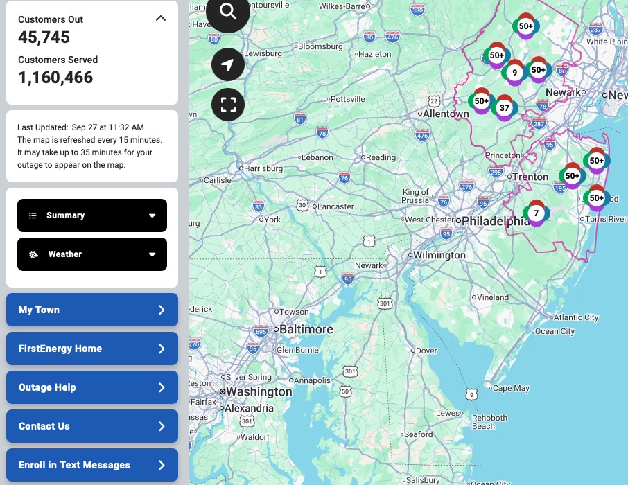
-

Strong Nor'Easter/Hybrid Storm Late September 2026
SnoSki14 replied to Rjay's topic in New York City Metro
Yes that too. Noreasters rarely last more than a day. -
weatherfront clears both on mobile, IMO, and I use it maybe 80% of the time on the web, only going to pivotal bc they have more parameters than WF
-
Strong Nor'Easter/Hybrid Storm Late September 2026
GaWx replied to Rjay's topic in New York City Metro
Is the long length of it noteworthy in relation to others? Isn’t this going to end up as a 48++ hour event in many locations? -

Strong Nor'Easter/Hybrid Storm Late September 2026
nycwinter replied to Rjay's topic in New York City Metro
i am surprised by the paltry power outages numbers. a storm like with strong winds for a extended period of time along with heavy rain and fully leafed trees i expected at least 100 k on long island with no power.. -

October Comes Early: Late September Multi-Hazard Hybrid Storm
Snowedin replied to WxWatcher007's topic in New England
More rain than our average snow event in January Looking at just over 3.5” here and a few good limbs that will undoubtedly need to be tossed! -
Strong Nor'Easter/Hybrid Storm Late September 2026
SnoSki14 replied to Rjay's topic in New York City Metro
Yes just because it didn't seem bad where you were doesn't make it any less noteworthy. A retro nor'easter in late September that caused widespread coastal flooding is significant. Gusts of 70+ were recorded. 3"+ amounts will fall. This is definitely a significant and pretty rare event. -

October Comes Early: Late September Multi-Hazard Hybrid Storm
dendrite replied to WxWatcher007's topic in New England
CON 110mph EWR 108 HFD 100 NYC 94 BDR 88 ALB 83 HVN 77 https://journals.ametsoc.org/view/journals/mwre/78/11/1520-0493_1950_078_0204_tdson_2_0_co_2.pdf -

October Comes Early: Late September Multi-Hazard Hybrid Storm
Bryan63 replied to WxWatcher007's topic in New England
Meh'd our way to just under 7.5" so far. Have water coming up out of the ground in the basement, damn this ancient house. -
Home from the beach and in some of the steadier rain and up to about .40” for the storm. I’ll be sad if this is the last batch. I love a fall rainy Sunday.
-
Strong Nor'Easter/Hybrid Storm Late September 2026
MANDA replied to Rjay's topic in New York City Metro
Great cause. Good luck! -

2026-2027 Record-breaking El Nino
mitchnick replied to Stormchaserchuck1's topic in Weather Forecasting and Discussion
I was surprised to see as well how much the Conus, especially east of the Rockies, stays at or BN for weeks after that week. And the AN is not excessive. https://charts.ecmwf.int/products/extended-anomaly-2t?base_time=202609260000&projection=opencharts_north_america&valid_time=202610050000 -

October Comes Early: Late September Multi-Hazard Hybrid Storm
WxWatcher007 replied to WxWatcher007's topic in New England
With a STJ on steroids this winter, there’s going to be an absolute nuke of a storm at some point. -
 7.21 Just keeps coming
 -

Strong Nor'Easter/Hybrid Storm Late September 2026
SI Mailman replied to Rjay's topic in New York City Metro
2.43 inch storm total so far. -

Strong Nor'Easter/Hybrid Storm Late September 2026
FPizz replied to Rjay's topic in New York City Metro
Similar here, 1.35" -
Really unusual track for September. Most early season coastal storms or tropical systems track N to NE up or just off the coast. Can’t remember a September system coming in from the east into NJ before. Goes to show how strong the 500 mb ridging pattern has been associated with the record 600dm ridge a few weeks back and strong ridging since March.
-
Supposed to go to an open house today....sort of meh on it with the weather....

.thumb.jpg.ad3a2e31d30aff035044689b311a0540.jpg)




