All Activity
- Past hour
-
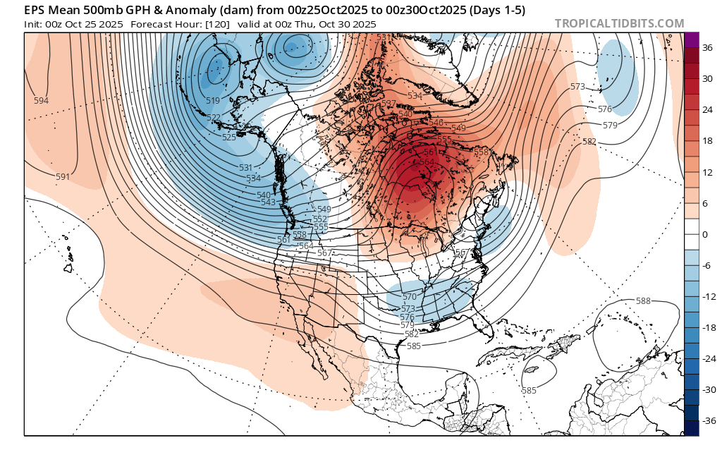
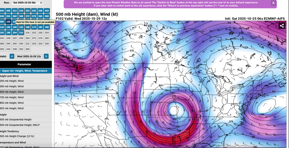
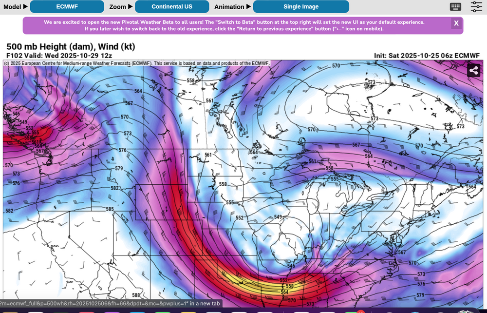
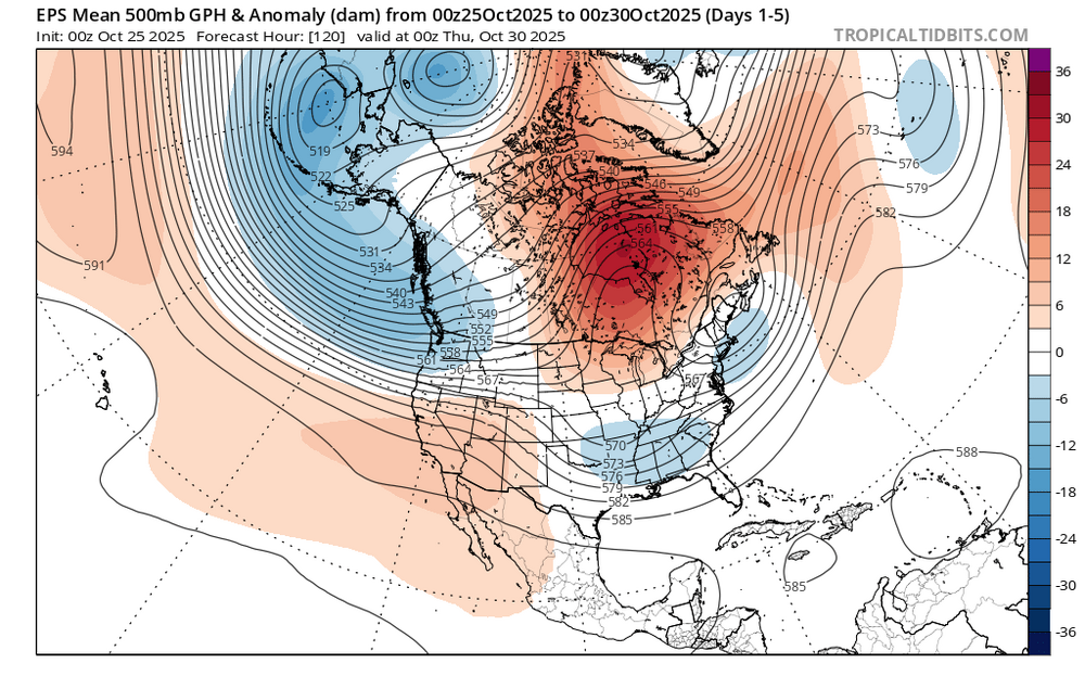
6z/25 EC and ECAI 5H at the same time - 102 hours out... note the huge difference in the ops at D4 off the east coast-New England-Great Lakes. Long ways to go to resolve what will happen.
-

Spooky Season (October Disco Thread)
kdxken replied to Prismshine Productions's topic in New England
-
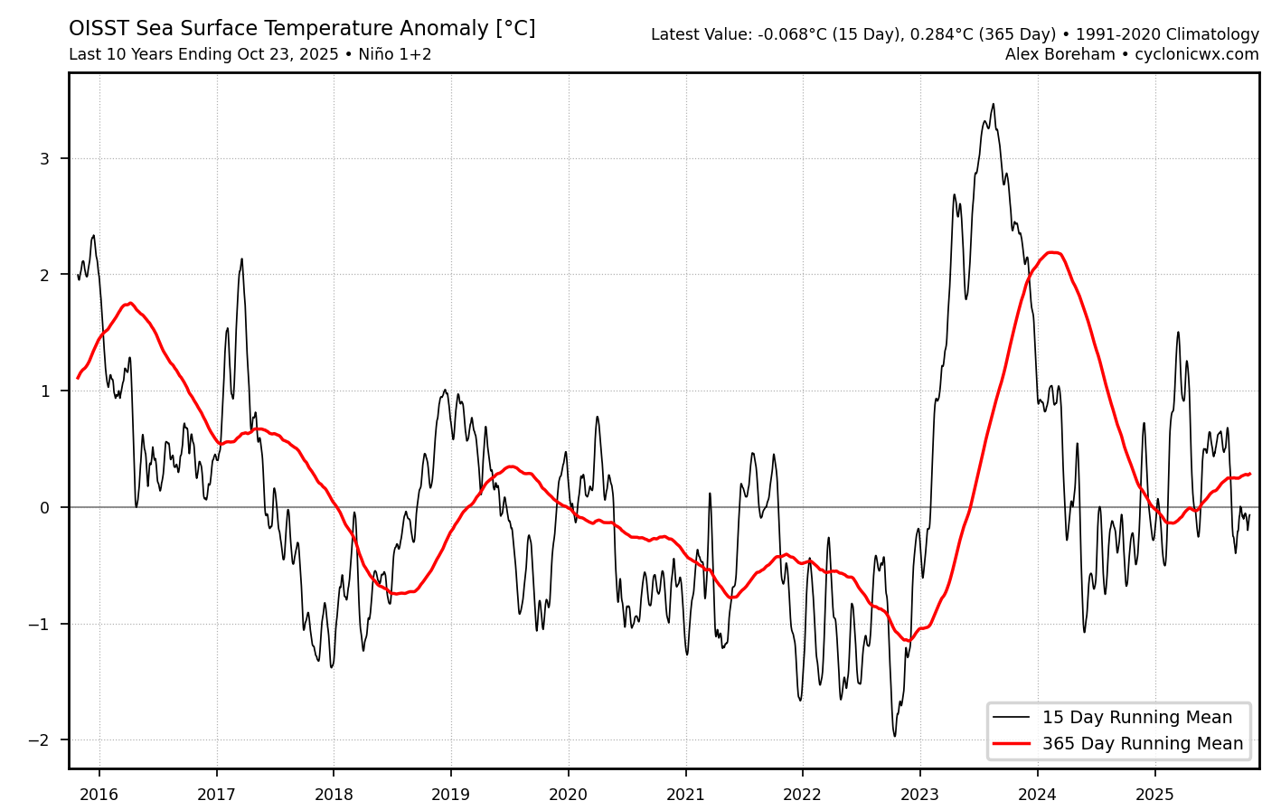
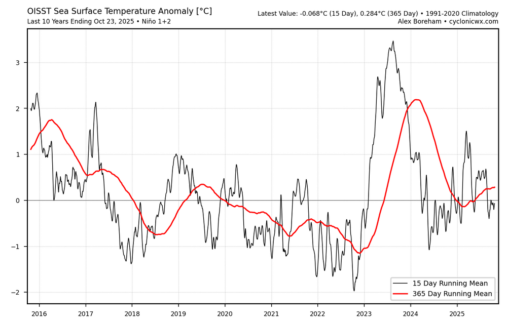
Nino 1.2 continues to run warmer than 3.4. This has been the recent theme with the EWBs not able to penetrate closer to the SA coast. It all began with the record WWB near the SA coast back in March 2023.

-
For anyone who may have saw the observation, I promise you all it’s not snowing at KMGJ, just frost, looks like the low will be 34 here.
-
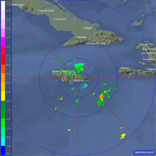
Maybe an eye showing on radar?
-

Central PA Fall Discussions and Obs
mahantango#1 replied to ChescoWx's topic in Upstate New York/Pennsylvania
29.7 this morning. Coldest yet for this fall season. Don't know how much longer I can hold out on this "No heat on till November" thing. 60 in the house this morning. -
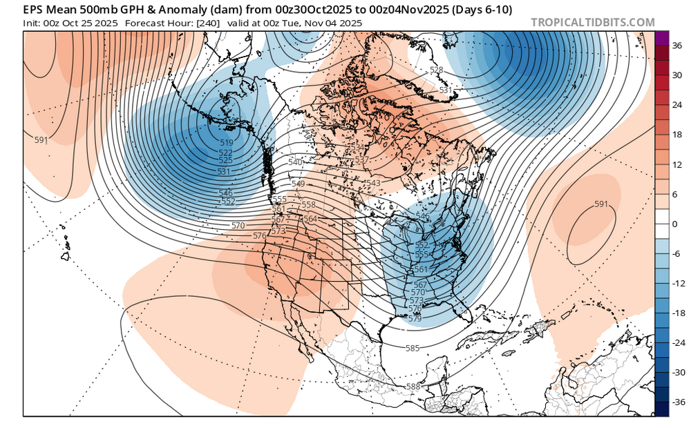
Pretty strong signal for a little cooler than average trough in the Northeast into early November.
-
@40/70 Benchmark The SOI is soaring again…almost +25. I like your new ENSO disco, I really think we see some Niña strengthening in both the subsurface and surface next month
-
39 degrees this morning. Felt way colder and much more humid feeling though. Loving this weather!
-

Spooky Season (October Disco Thread)
512high replied to Prismshine Productions's topic in New England
33F for the low, change the clocks next weekend, jeez ! -
Anyone else worried that NWS is relying on Google’s DeepMind model too much.
- Today
-
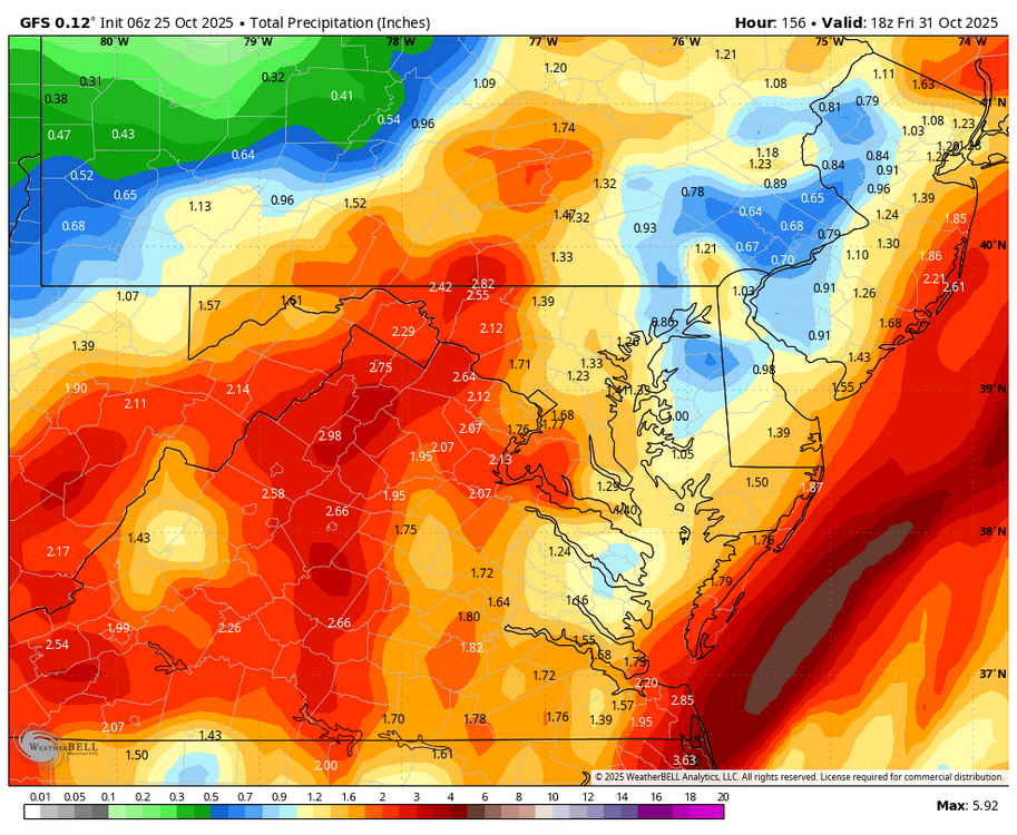
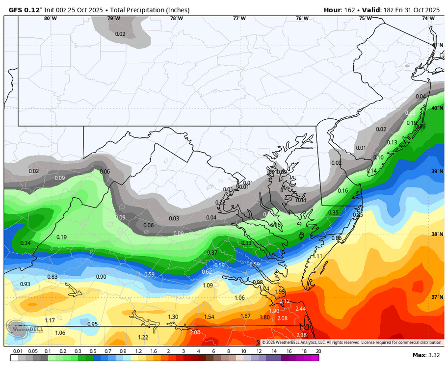
Good Saturday morning all. Beneficial rain is coming 10/29-31, along w a short period of wind gusts on the coast near 50 with associated spotty power outages, and then behind the the system widespread gusts 40 MPH around 10/31 or 11/1. Rainfall still uncertain but certainly more than 1/2" and a couple climate sites may exceed normal monthly totals with potential for near 3". Target for the heaviest rain uncertain but modeling is coming into more agreement. One thing to note... yesterdays 18z GFS had nil but its ensembles about 1" in NYC. Also, fwiw, the ensembles have so much spread that they are comparatively timid in comparison to the OPS rain and wind production. Despite tides astronomically modest, I think there could be a period of minor tidal flooding. Right now not quite as fierce as the prior (10/12-13) thread, so no new event thread, as yet.
-
35 in the lowlands. Coldest yet this season.
-
Can’t really lean on any AI data unless you know the integrity of the data used to train the AI.
-

E PA/NJ/DE Autumn 2025 Obs/Discussion
Birds~69 replied to PhiEaglesfan712's topic in Philadelphia Region
36F at 6:40am which will probably be the low. Overnight lows slowly but surely getting close to freezing.... -
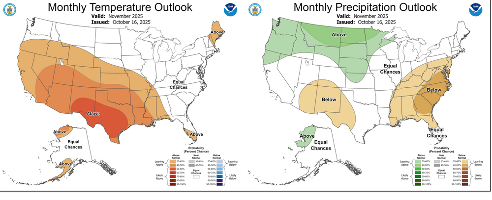
Added CPC's Oct 16 outlook.
-
WB 6Z GFS compared to 0Z...lets see if it holds.
-
The last time a Greenland Block worked in our favor with a KU here along the 1-95 corridor was February 2021. The MJO 8 in January 2022 was more of a Pacific driven snowfall pattern. Most other Greenland blocks like December 2022, March 2023, and February 2025 were Southeast ridge link ups with Great Lakes cutters or I-78 to I-84 hugger tracks. Prior to 2019 there Southeast ridge link ups with Greenland blocks were rare. Like in December 2012 and the late 1990s. But those were usually followed up by more favorable Greenland blocking patterns and KU snowstorms in the next months or years which hasn’t happened yet.
-
BWI 37 at 0600.
-
DCA hit 39 at 0545. Coldest since April.
-
Props to the gfs
-
LWX reported Dulles hit 32 at 0430. Now down to 30.
-

Spooky Season (October Disco Thread)
Modfan2 replied to Prismshine Productions's topic in New England
Down to 31F here in the Quinebaug Valley -
31 this morning last mow day today. Wish me luck
-
We're getting a lot of steady light to moderate rain over hours. This is the best because it soaks in does not run off.