All Activity
- Past hour
-

Boxing Night Snow/Sleet/Ice Dec 26-27 Storm Thread/Obs.
LVblizzard replied to Mikeymac5306's topic in Philadelphia Region
It sucks running a page with 13k followers during a storm like this. You barely have a clue but the people demand numbers and you just have to do your best. -

Snow Potential Dec 26-27
SomeguyfromTakomaPark replied to WeatherGeek2025's topic in New York City Metro
That’s nice beefy qpf, thought that was a kuchera map at first. -
18Z for reference
.thumb.png.ec9035ff92844b453291f13a7aa0a636.png)
-
Boxing Night Snow/Sleet/Ice Dec 26-27 Storm Thread/Obs.
LVblizzard replied to Mikeymac5306's topic in Philadelphia Region
None of the other 0z mesos look remotely like that NAM run. I'm tossing the NAM at this point as it's such a big outlier. -
Icon slightly north
.thumb.png.c133cc1b5768f331300e5bde331a224c.png)
-

26th-27th event, coming at us like a wounded duck.
CoastalWx replied to Go Kart Mozart's topic in New England
Icon ticked north too. Not like Nam though lol. -
Yeah the low can still be not too far north but we all get sleet instead of snow because of that mid level warmth. Southwest flow event storms like these tend to have more mid level warmth than expected. Been countless instances of storms with this track (not just in 2020s but 2010s as well), where the precip is delayed and then we have mainly sleet from the onset and the totals end up being cut in half of What was originally expected
-

White Christmas Miracle? December 23-24th
The 4 Seasons replied to Baroclinic Zone's topic in New England
2020 melted Christmas Eve/Day straight up through Maine with a 50s/60s pouring rain thunder stem winder. 2013 Not sure -

Boxing Night Snow/Sleet/Ice Dec 26-27 Storm Thread/Obs.
RedSky replied to Mikeymac5306's topic in Philadelphia Region
New NAM is coming north by how much will soon know -
Absolutely not. A big hit would be 6-8+”. 4” snowfalls happen on average a few times a year. This decade has been filled with ratters though so that skews our mindset. That being said, if central park measured properly, they would have had 4” in the last storm along with the February 2024 storm. They just don’t measure properly
-
The 18z EPS had a few members in that vicinity. And the GEFS had a few that were a little south but close. That surface track is possible though still somewhat unlikely. The mid-level low tracks are possibly more important.
-

Boxing Night Snow/Sleet/Ice Dec 26-27 Storm Thread/Obs.
Ralph Wiggum replied to Mikeymac5306's topic in Philadelphia Region
Yep. Complete nowcast event probably. -
Boxing Night Snow/Sleet/Ice Dec 26-27 Storm Thread/Obs.
Ralph Wiggum replied to Mikeymac5306's topic in Philadelphia Region
I dont believe this is a "non event". -
Boxing Night Snow/Sleet/Ice Dec 26-27 Storm Thread/Obs.
LVblizzard replied to Mikeymac5306's topic in Philadelphia Region
Forecasting this is like blindly throwing darts at the models and hoping one will be right. It's such a weird setup and the models apparently don't know how to handle it. You can't really look at past storms as analogs with this either because it's so rare to get storms like this. -
Boxing Night Snow/Sleet/Ice Dec 26-27 Storm Thread/Obs.
Ralph Wiggum replied to Mikeymac5306's topic in Philadelphia Region
AIGFS all snow SE PA -

26th-27th event, coming at us like a wounded duck.
RUNNAWAYICEBERG replied to Go Kart Mozart's topic in New England
I’m trying to take winters in stride more and really enjoy seasons when it feels like winter again. So far so good this month… -
Boxing Night Snow/Sleet/Ice Dec 26-27 Storm Thread/Obs.
Ralph Wiggum replied to Mikeymac5306's topic in Philadelphia Region
Hrrr looks like the upgraded NAM with NYC dryslotted and a stripe over S PA. Model mayhem -
Currently 40.5/30.6 at 9:45 pm after a 61.4 degree high this afternoon.
-
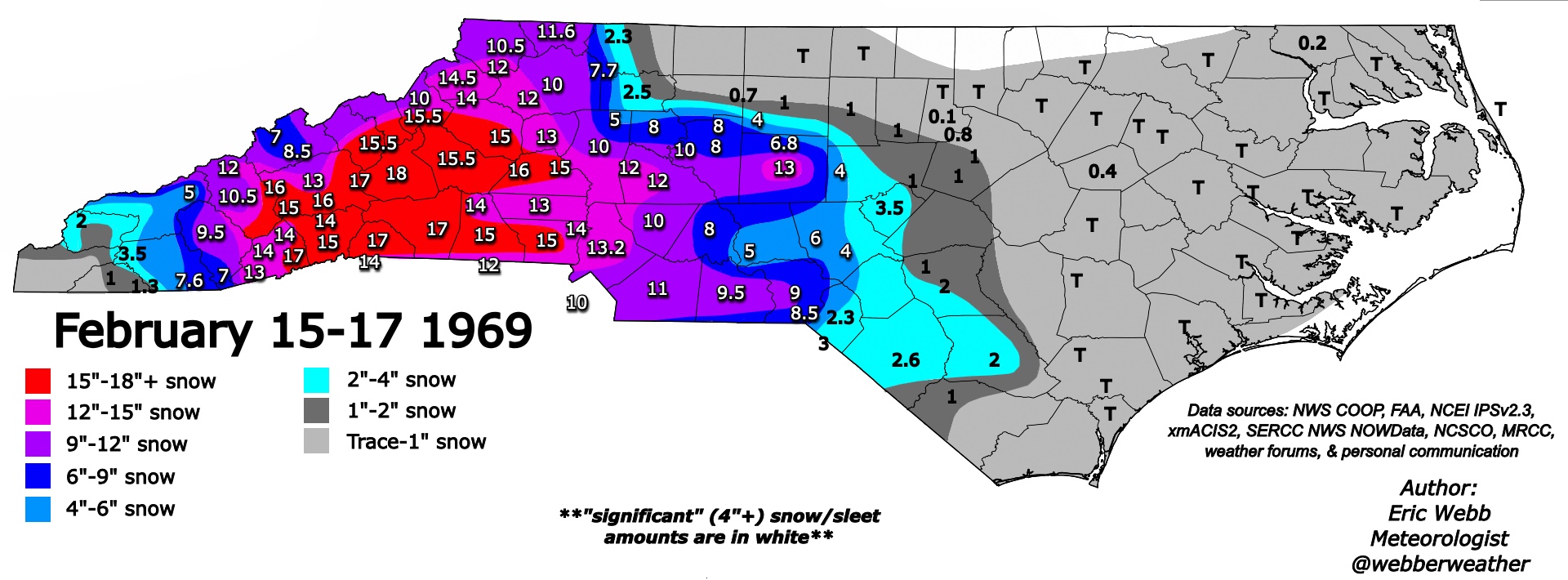
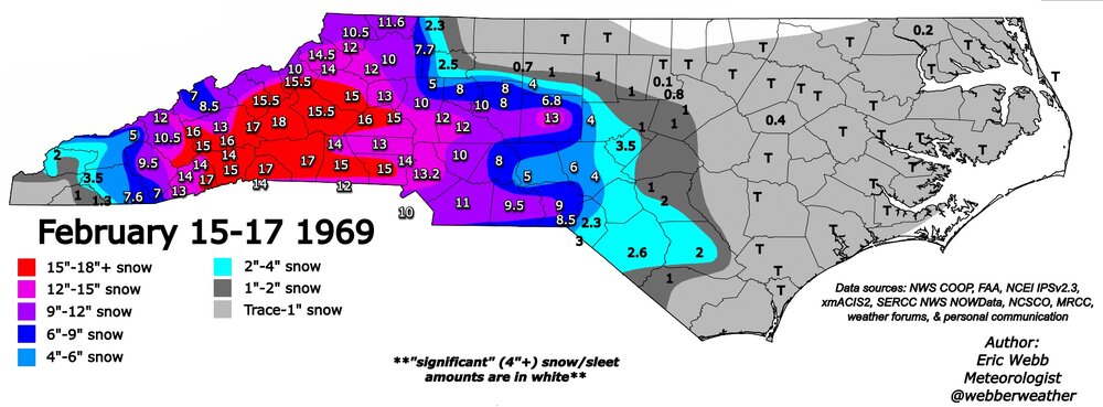
Merry Christmas everyone. Us foothills folks deserve a February 1969 redux for Christmas
-

White Christmas Miracle? December 23-24th
TauntonBlizzard2013 replied to Baroclinic Zone's topic in New England
Every single one of them. I don’t even think we were close on any of them, as in, they were gone several days before -
Flurries possible overnight? Radar, HRRR, FV3 etc say maybe. But only Santa will know.
-
My wife's home town in Wyoming broke it's record for Christmas eve by 9 degrees and tied the all time December high temp of 65
-
Boxing Night Snow/Sleet/Ice Dec 26-27 Storm Thread/Obs.
Ralph Wiggum replied to Mikeymac5306's topic in Philadelphia Region
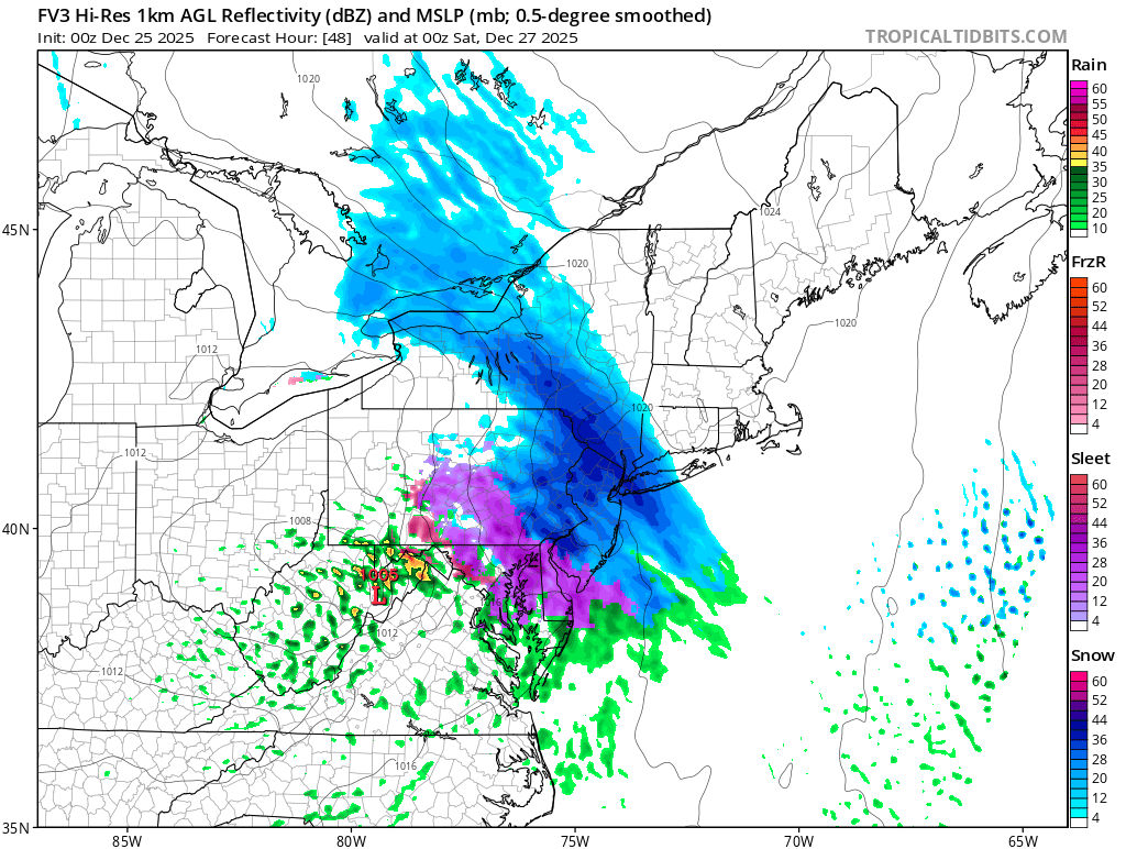
Fv3 is a significant snowstorm ha!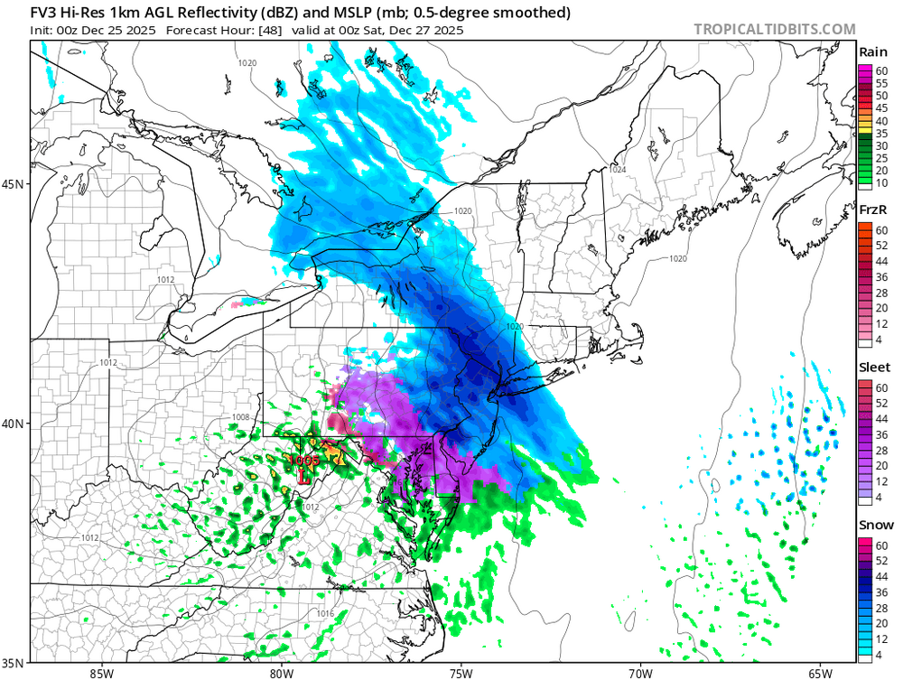
-

Central PA Winter 25/26 Discussion and Obs
AccuChris replied to MAG5035's topic in Upstate New York/Pennsylvania
Too soon to tell. This is one run of one model but will need to see what the rest of the 0z suite shows . -
Thank you. Have a wonderful Holiday season, too.

.png.18966b6115d8507cb9b0d9d710a6fcb6.png)

.png.4459d17a79c803abb7866353c0d9d954.png)