All Activity
- Past hour
-
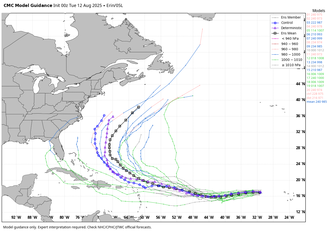
WB 0Z ensemble tracks.

-
 62, beautiful sunrise. Must've had a sprinkle of rain overnight as my windshield has dried up water drops on it.
 -
@jconsor lad posted this https://hurricanehacker.substack.com/p/tropical-storm-erin-forms-in-eastern
-
What happened mate
-
EPS is pretty wet Thursday
.png.8e7a9815c7b7dc23aaa9c13626c35b67.png)
-
Another dewless hot summer day. Find water
-
Area Forecast Discussion National Weather Service State College PA 416 AM EDT Tue Aug 12 2025 .SYNOPSIS... -- Changed Discussion -- * Humid with locally heavy thunderstorm downpours tonight and Wednesday * Mainly dry with above normal temperatures all weekend -- End Changed Discussion -- && .NEAR TERM /UNTIL 6 PM THIS EVENING/... -- Changed Discussion -- Patches of lower clouds have started to form over the Lower Susq and Laurels. While not a widespread deck yet, it is expanding. Much of the area could have these clouds (which are currently 1500-2000ft aloft). That could make it more difficult for us to reach the NBM mean MaxTs. But, mixing should help break these clouds up for the most part. Without much confidence in the persistence of the clouds, we`ll hang close to guidance for the time being. Many of the CAMs pop taller cu and even isolated showers this afternoon, mainly S of UNV. They`ll get tallest over the ridges/high ground and only drift away slightly. Coverage of any showers is expected to be pretty sparse, and only worthy of a 20-30 PoP. -- End Changed Discussion -- && .SHORT TERM /6 PM THIS EVENING THROUGH WEDNESDAY NIGHT/... -- Changed Discussion -- All of the pop-up showers around this afternoon will die off around sunset. The advancing upper trough will really break down the ridge and drag a cold front into OH overnight. There will be some showers and possibly a thunderstorm get into the western zones before sunrise Wed. Lows tonight will be milder, especially in the Lower Susq where they should stay in the 70s. Pre-frontal weaknesses in the pressure field will allow storms to continue going during the morning hours as the front nears the CWA. The afternoon heating will increase the coverage of the storms with skinny but tall CAPE NW, and fatter CAPE as you move SE. 0-6km shear will be around 30kt for BFD, but only 20kt at UNV and MDT. These numbers aren`t enough to cause concerns high enough to the SPC outlooks, but a strong-er storm is possible. The high PWAT (1.7-2.0") and slow moving storms may make heavy downpours. That shouldn`t be much of a concern, either due to the very dry conditions of the past week plus. It`s been about two weeks since Happy Valley has had measurable rainfall. Lancaster and Bedford counties had very heavy rain ~10-12 days ago, but not much (if anything) since then. The front seems like it moves only slowly when it gets into Central PA, and should yield more showers and storms. Expect these to drag in the southern zones until the middle of Wed night. The dry air does make inroads across the north. -- End Changed Discussion --
-
Time to track the tropics
-
Maybe to you but others on Facebook, Twitter and other forums will continue.
-
I agree with you.
-
The EURO seasonal is showing classic La Niña/-IOD low frequency forcing over the eastern IO and Maritime Continent for OND:
- Today
-
65° / 60° cooled off a little bit more than I expected. Had to shut off the air conditioning during the night.
-
Looks like nothing to watch and track.
-
Big changes in the models last night today is important
-
Looks like the positioning is a little further south than modeled, looks like we watch and track.
-
Hard to believe with all the rain the last few months, that this is happening. https://www.abc27.com/news/multiple-dauphin-county-areas-announce-voluntary-water-restrictions/?utm_medium=social&utm_source=facebook_abc27_News&fbclid=IwY2xjawMH2ptleHRuA2FlbQIxMQABHm4UIfmxNklzCR8u_6jK8My845BbUBFxPKbq01SDok7xSpiDaTtq3Zsa0Y68_aem_GTqxn89hJvPMaAoFaAyD_w
-
-
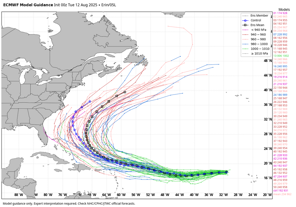
0Z Euro: still recurves well offshore the Conus but at 73W, which is significantly further W than the 69-70W of the prior 2 full runs.
-
Based on the gfs and euro ensembles there is a 5% chance that there could be an impact on southern New England which means I believe this will be wide east but maybe Atlantic Canada can’t be ruled out
-
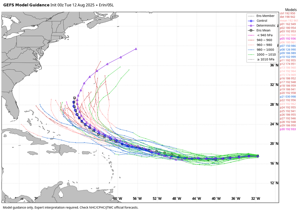
0z GEFS ensemble members are south of 18z through 186.
-
 Yes, hoping tomorrow evening still has good viewing because moon will rise a bit later (it's 10:00 pm here, already cooled down nicely to 72 F, and a big old moon looking like God's ear above the horizon now in east-south-east). Except for moon we have very dark skies outside of town here, good for viewing auroral displays and meteor showers and night sky etc.
 -
The 0Z GFS hits Bermuda hard with the center just missing to the NW. 0Z CMC passes ~250 miles W of Bermuda.
-
BANK ON IT. It will happen. Get the shovels ready. You'll all be GLUED to models for months. Your BACKS will hurt BAD. You are about to shovel about 50 years' worth of snow. Next winter will be even snowier. YOU ARE GONNABE SO DAMNED TIRED OF SNOW BY LATE JAN 2026, it will be ridiculous! You guys have had this coming for a long while. These, will be the Days To Remember. Joel says they will not last forever, but I got news for you! It WILL last "forever" for many. BIG ALTERATIONS COMING!
-
0Z 8/12 UKMET: similar to 12Z with it recurving at 66.5W and threatening Bermuda: TROPICAL STORM ERIN ANALYSED POSITION : 17.8N 31.2W ATCF IDENTIFIER : AL052025 LEAD CENTRAL MAXIMUM WIND VERIFYING TIME TIME POSITION PRESSURE (MB) SPEED (KNOTS) -------------- ---- -------- ------------- ------------- 0000UTC 12.08.2025 0 17.8N 31.2W 1010 29 1200UTC 12.08.2025 12 17.4N 35.3W 1008 31 0000UTC 13.08.2025 24 17.2N 39.3W 1008 30 1200UTC 13.08.2025 36 17.0N 42.6W 1007 29 0000UTC 14.08.2025 48 17.3N 45.3W 1008 29 1200UTC 14.08.2025 60 18.3N 49.0W 1008 29 0000UTC 15.08.2025 72 19.2N 52.1W 1008 28 1200UTC 15.08.2025 84 20.3N 55.5W 1008 33 0000UTC 16.08.2025 96 21.0N 58.8W 1007 34 1200UTC 16.08.2025 108 21.8N 61.0W 1004 43 0000UTC 17.08.2025 120 22.4N 63.8W 1002 43 1200UTC 17.08.2025 132 24.2N 65.6W 1000 45 0000UTC 18.08.2025 144 26.6N 66.5W 998 42 1200UTC 18.08.2025 156 28.6N 66.5W 995 43 0000UTC 19.08.2025 168 30.8N 65.6W 992 47
-
Looks like a high end tropical storm on the cusp of a hurricane