All Activity
- Past hour
-

July 2025 Obs/Disco ... possible historic month for heat
jbenedet replied to Typhoon Tip's topic in New England
It does look like we have quite the baroclincity for Thurs to work with for the calendar—> surface to mid level frontogenesis. So I could buy something like the 6z Rgem, at the same time I do believe that area will be narrow and cold front esque in distribution on the north side. West and south into upstate NY and PA look best setup for the broad 0.75” + amounts. Don’t think that changes. They also need the rain much less than we do… -

July 2025 Obs/Disco ... possible historic month for heat
CoastalWx replied to Typhoon Tip's topic in New England
Man euro is a furnace in the extended. -
IOD and PDO are completely different entities
-
July 2025 Obs/Disco ... possible historic month for heat
CoastalWx replied to Typhoon Tip's topic in New England
Yeah NE PA into SE NY state ftw. Might be a narrow area extending into CT to RI and SE MA. -
July 2025 Obs/Disco ... possible historic month for heat
jbenedet replied to Typhoon Tip's topic in New England
Yea it’s been brutal for those who care about their property. A lot of up keep, expensive water bills. And still dog shit aesthetic results because, you’re fighting too much in mid summer through a chunk of august. and the conservation of water initiatives rolled out by local cities are counter to green scaping to reduce UHI/global warming affects.They have to figure something out on this. -
Yup. Just in time for my Aug 2-9 trip to Chincoteague.
-

July 2025 Obs/Disco ... possible historic month for heat
40/70 Benchmark replied to Typhoon Tip's topic in New England
The second half of the summer has really pinned successive rain events south of the pike and over towards CT. -
2025-2026 ENSO
40/70 Benchmark replied to 40/70 Benchmark's topic in Weather Forecasting and Discussion
Yea, I wanted to use it in my blog update last week....sucks. -

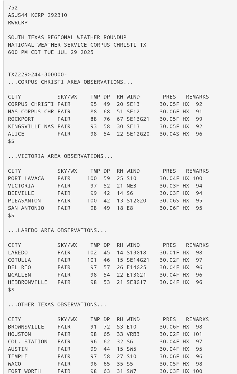
Texas 2025 Discussion/Observations
Stx_Thunder replied to Stx_Thunder's topic in Central/Western States
On another note, sfc dew points and humidity values were majorly below normal this time of year in the coastal bend, early evening Tuesday. CRP dew point bottomed out at 49 F with just 20% humidity value in the early evening. Well below the normal 70+ F dew point throughout the entire summer (day & night).
-

July 2025 Obs/Disco ... possible historic month for heat
Modfan2 replied to Typhoon Tip's topic in New England
Some models showing heaviest precip west of CRV towards NYS; let’s see how that plays out -
July 2025 Obs/Disco ... possible historic month for heat
jbenedet replied to Typhoon Tip's topic in New England
Moderate+ Drought is again a real problem for a chunk of us. Really hoping Thursday drying trend on guidance flips today. Could really use an 1”+ from that here -

July 2025 Obs/Disco ... possible historic month for heat
BrianW replied to Typhoon Tip's topic in New England
76 BDR and HVN for lows. Already up to 79 at HVN.
-
.thumb.png.4150b06c63a21f61052e47a612bf1818.png)
July 2025 Obs/Disco ... possible historic month for heat
HIPPYVALLEY replied to Typhoon Tip's topic in New England
Low of 65° here. The clear nights have helped us radiate a little. Clear skies and I only saw two meteors last night so that was disappointing. -

Central PA Summer 2025
Mount Joy Snowman replied to Voyager's topic in Upstate New York/Pennsylvania
So it appears the Hawaii warnings were downgraded and minimal damage reported. Good news. Tomorrow’s dew points look like they could be the worst of the week, with relief not arriving until the overnight hours. We’ll see what tricks the storms pull. -

July 2025 Discussion-OBS - seasonable summer variability
bluewave replied to wdrag's topic in New York City Metro
Corona and Brownsville maxed out at 103°. 13th St./16th / Alphabet City 100 82 90 104 88 78 33 0.00 14 3:00pm 6 3:55pm 24.6 160 Ave. / Howard Beach 92 76 84 105 76 95 55 0.00 28th St. / Chelsea 100 81 89 104 86 82 34 0.00 13 4:05pm 6 4:05pm 23.9 Astoria 100 79 90 105 79 85 32 0.00 10 6:30pm 3 6:40pm 20.7 Bensonhurst / Mapleton 97 79 88 106 79 87 42 0.00 23.9 Bronx Mesonet 99 77 88 101 77 84 32 0.00 15 2:35pm 8 12:00am 23.7 Brooklyn Mesonet 95 78 86 100 78 86 39 0.00 23 6:30pm 16 6:30pm 26.2 Brownsville 103 80 89 105 80 82 31 0.00 Corona 103 80 90 109 80 83 30 0.00 E 40th St. / Murray Hill 99 80 90 103 85 82 35 0.00 East River at Alphabet City Fresh Kills 11:10am 11:10am 6.7 Glendale / Maspeth 100 80 90 105 80 82 34 0.00 Gold Street / Navy Yard 99 80 89 104 80 83 34 0.00 16 5:30pm 6 3:15pm 25.4 Lefferts / South Ozone Park 96 77 86 107 77 89 47 0.00 Manhattan Mesonet 96 79 88 100 79 80 36 0.00 15 2:00pm 9 2:00pm 26.2 Newtown / Long Island City 100 82 90 104 87 77 32 0.00 14 5:45pm 8 4:55pm 25.2 Queens Mesonet 96 78 86 101 78 84 38 0.00 24 5:25pm 17 6:00pm 24.1 Queensbridge / Dutch Kills 102 82 91 105 88 77 32 0.00 22.8 Staten Island Mesonet 98 74 87 101 74 95 33 0.00 16 2:15pm 10 -

July 2025 Obs/Disco ... possible historic month for heat
dendrite replied to Typhoon Tip's topic in New England
62.8° Another comfy morning sandwiched around big daytime heat. Like the days of yore. -

July 2025 Obs/Disco ... possible historic month for heat
kdxken replied to Typhoon Tip's topic in New England
70° / 66° -

Chester County PA - Analytical Battle of Actual vs. Altered Climate Data
chubbs replied to ChescoWx's topic in Climate Change
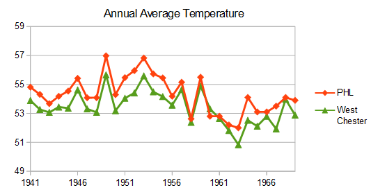
The big difference between the Phila Airport and the Chesco station average occurred in the 1945-1970 period. That's when the Chesco station average cooled significantly relative to other regional stations. Before 1945, Chesco COOPs were as warm as the Philly Airport or the Newark DE Ag station. By 1970, Chesco COOPS were as cool as Allentown. The cooling was mainly due to station moves: Coatesville 1946/47, Phoenixville 1948 and West Chester 1970. A reverse heat island effect for Coatesville and West Chester. Meanwhile the Phila Airport tracked other regional stations and West Chester before the 1970 West Chester move. The raw data is very clear. The Phila Airport is a much more consistent source of climate data than the Chesco COOPs. PHL's consistency advantage grows when non-COOP data is added making the Chesco data even more inconsistent.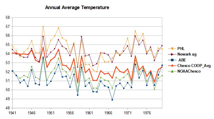
- Today
-
Another note on the warmth: today will be the 22nd day with a low of 70 or above. That is the most ever through the end of July, 12th most in an entire summer, and the most in an entire summer at the airport site with still the entirety of August to go. All of the other years with this many 70+ lows occurred with observations taken downtown.
-

July 2025 Discussion-OBS - seasonable summer variability
wdrag replied to wdrag's topic in New York City Metro
IF NWS issues a flood watch, will start a thread. Its marginal right now but I expect more or less what WPC has posted this morning with isolated max rainfall of 6". No thread at this time. -
July 2025 Obs/Disco ... possible historic month for heat
kdxken replied to Typhoon Tip's topic in New England
. QPF box-and-whisker diagrams from the 00z LREF, which utilize the coarser-res ensembles (EPS/GEPS/GEFS) and not the finer- scale guidance which we`re not yet in the forecast horizon to see their output as yet, shows QPF values around 1-1.5" in the 50th percentile at sites like Hartford and at Providence, but show values potentially reaching up to 3". Pretty good signal for steadier soaking rains, supported by the ECMWF EFI/Shift-of-Tails guidance which also offers potential for an anomalous rain The ol' box-and-whisper and Shift-of-Tails. I check them every morning... -
Texas 2025 Discussion/Observations
Stx_Thunder replied to Stx_Thunder's topic in Central/Western States
'Rest of Summer 2025 is looking good for less TX insane heat, and more convective action. Ensembles have been pretty consistent in forecasting fleeting (rather than dominant) subtropical ridging since the season began. And I don't see any reason this will change much, or to disagree with CPC's monthly outlook for August with equal chances on temps and precip in the state (instead of just outright throwing in above normal probability temp shades as usual). This weekend, and possibly even later next week or into mid August is looking a bit convectively interesting with a non-tropical mid-upper level pattern developing as the flow turns North across most, if not all the central and eastern half of state due to the typical mid-upper High moving off to the west. And troughing digging further south through the Plains than usual this time of year. Which will likely push a front into the state this weekend. The AO edging into the negative phase in the coming days also supports this (as I've seen in past years). Both Euro & GFS are even starting to hone in on modest DL shear getting deeper into the state as well in more recent runs. So stronger storms are not out of the question. Especially with a +PNA phase already in place. Only real caveat this weekend looks to be mostly meager mid-level lapse rates around 6 (except maybe NTX). Next weekend is looking steeper further south.
-
July 2025 Obs/Disco ... possible historic month for heat
dendrite replied to Typhoon Tip's topic in New England
Looks like we got our usual tsunameh -

July 2025 Discussion-OBS - seasonable summer variability
dmillz25 replied to wdrag's topic in New York City Metro
Wasn’t expecting yesterday to be the third 100 degree day of the year for me. Crazy -
Greensboro's all time record max min is likely to be set for a single month, the lowest it has dropped was 68 degrees which would beat the old record of 67 set in 2016 and 2015 (July as well). We are only +2 on the month, I think that the lack of a break from the heat/humidity is what has made this July feel worse than the last few.