All Activity
- Past hour
-
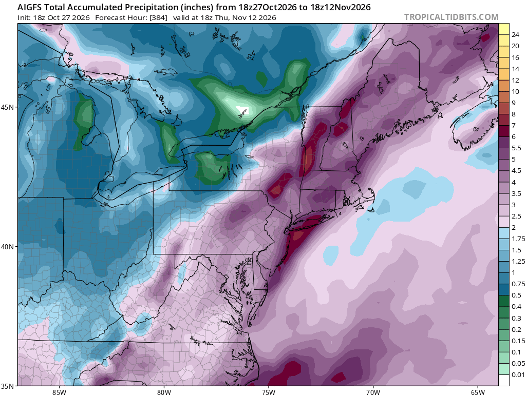
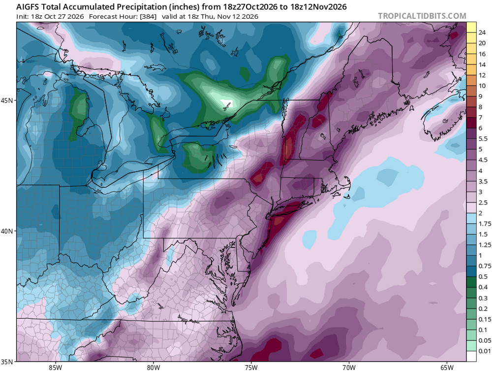
I have told people that I would expect a wet winter, at minimum, for the region. Snow or no will come down to timing of cold air shots and hopefully some high latitude blocking that can lock in eastern Canadian high pressure. We could easily miss everything and get cold rain, but this season will have one of the better opportunities for precipitation in a long while with the southern jet likely to be very active for months.
-
This would be pretty insane to see occur this early. Wow
-
 buying prescription drugs in mexico: FronteraCareDirect - mexico prescription online
-
The perfect cliche of….A Cold November Rain. So appropriate.
-
2026-2027 Record-breaking El Nino
BuffaloWeather replied to Stormchaserchuck1's topic in Weather Forecasting and Discussion
Quality content in here today. A+ -
My sense was no lol
-
62 today. Really an incredible month
-
2026-2027 Record-breaking El Nino
LibertyBell replied to Stormchaserchuck1's topic in Weather Forecasting and Discussion
I think we're in a cyclic dry pattern now. 65-66 72-73 and even a non nino like 01-02 would be my analogs That won't stop next summer from being a very hot and dry summer. Told you Ray lol This is exactly why rainy winter forecasts are in trouble. I see similarities to 01-02. Non nino analogs like 01-02 also come into play. Below normal in the south because it's cloudy not because there's any arctic air around. Cyclical is why I use 65-66 and 72-73 as analogs and even a non nino analog like 01-02 because we entered a drier pattern in 2024. That kick started the dry pattern in 2024 It actually goes with 2001 fairly well It should be just like it is right now. Mild and sunny not rainy. Dont be so sure, the STJ can be suppressed like it was in 65-66 and 72-73. We are starting a new drier pattern. 2024 was the first sign. They did not forecast the eastern dryness either Yes. 5c warmer, there is a search for earth like planets like this they are called superhabitable. So far one has been found but it's 1100 light years away. Yes and we already had a cold snowy winter last year. Why do these people need one every year? That's partially true. However he's right astronomers consider earth like planets 5c warmer to be superhabitable. People will have to move away from the coast anyway and the government will stop new developments there and insurance companies won't cover it. There is a strong risk of suppression. And also 95-96 and 10-11 la ninas after El ninos are the best for hot summers and snowy winters which is why they go together. Yes this reminds me of the 2004 ALCS 19-7 loss by the Red Sox. Look what happened after that. After the 23-24 we kick started a very dry pattern dont be surprised if history repeats itself Chris. Yes which is exactly why some non nino analogs should also be looked at. -
Is she going to go? I do believe making her go to that game could be considered abuse of some kind.
-
These would be some nasty cold rains if they work out.
-

2026-2027 Fall/Winter Mountain Thread
franklin NCwx replied to BlueRidgeFolklore's topic in Southeastern States
Its looking great in the southern mtns at 2500 and below -
Just cocked up
- Yesterday
-
I’d probably use Blue Hill as the standard for sunshine hours.
-
The haze / air quality was very noticeable in the ridge/valley region. Dampened my leaf spotting vibe. Just about peak in Alleganey / Washington counties.
-
Nobody is arguing that it won’t stretch or split. But the vibe coming from all this acts like a colonial winter is coming.
-
buying prescriptions in mexico [url=https://fronteracaredirect.com/#]FronteraCareDirect[/url] online pharmacy in mexico
-

Winter 2026-2027 Seasonal Outlook
NC_hailstorm replied to WinstonSalemArlington's topic in Southeastern States
The ECMWF still has a SSW reversal (60N) on November 4th,may be the earliest I've ever seen.Anyways I'd watch for an - AO tanking middle/late November. -
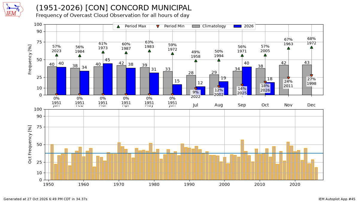
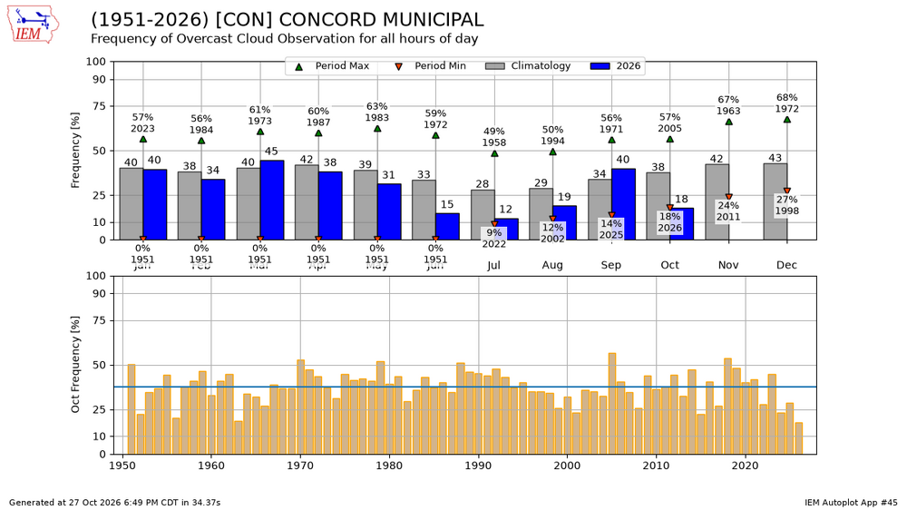
May have to be careful here…not sure. Once METAR took over in 1996 everything went to <= 12kft ceilometer observations. A few of the larger airports did augment higher levels in, but I’m not sure how consistent that has been. BOS has had a 25kft ceilometer for awhile now, and does consistently augment, but I’m not sure how the high level coverage compares to the pre ASOS days with manned SA obs. At least Fish was smart enough to use BOS. @vortex95 would probably know more on that Here’s CON. A big “drop off” in cloudiness in 1996 once the ceiling reporting stopped at 12kft. It’s pretty stupid seeing obs reported as CLR/Fair when it’s totally overcast at 15kft.
-
Yeah I saw that… the AI has been flagging that period for a few runs. Not necessarily cold but something interesting.
-
It is going to take a LOT to overcome the Pacific influences. The other thing too is it looks like the brunt of strongest influences from what may transpire with the PV will be more over Europe than our side of the Globe
-
Dont you people ever get tired of the endless rains? October 2024 was perfect any socalled wild fires aren't a problem here outside of August 1995. This isn't California. And this weather is exactly what we need. Yes temporarily. There can be a lot of southern branch moisture but it doesn't mean it will come north. It didn't in 1965-66 and 1972-73 and it didn't in 2001-02 I envision it hitting the Carolinas and Virginia not up here thankfully. 2024 kickstarted a drier pattern similar to the earlier one. LOSE WEIGHT Dont be so sure that will happen and if it does it will be a small blip and this pattern will return in a modified form by later December into January.
-
I texted my daughter this and she only responded “lol yeah I saw”
-
If we had some blocking or maybe Bering Sea ridging then it’s possible we could see impacts, but we will be fighting the Pacific influence.
-
Really all this strat PV hoopla because of some 10mb charts I mean come on lol
-
Some see super Nino and just automatically fixate on that one aspect.