All Activity
- Past hour
-
Some of the more notable high temperatures reported by ACIS for the Pine Tree State, include: 99 at the Houlton Band of Maliseet Indians Tribal Soil and Climate Analysis Network station, 98 at Augusta State Airport and Dixfield, 97 at Fryeburg and Millinocket, and 96 at Bangor. Among co-coops reporting in the morning (attributed to the following day - i.e., today), Topsfield 2 reached 98 and Van Buren 2 topped out at 95. The 99F reading at the HBMI TSCAN site matches the highest temperature reported by ACIS for the month of August in the State of Maine since 2002. The last time it reached 99F (as per ACIS data) in the state of Maine during the month of August was on August 12, 2016 at Portland Jetport Airport. The last time it reached 100F+ was August 15, 2002, when it topped out at 101F at Livermore Falls 1 E. Fryeburg topped out at 100F on the day prior (August 14, 2002). Above is a partial listing of all highs >92F for August 11, with all of the late reporting data below.
-
Did you look at 6z unless they all turned right after that.. some might have been good
-
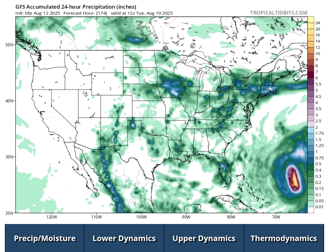
It's coming..
-
Ended with .36" here, of which .30 fell this morning. Been the summer of near misses IMBY where we are barely keeping drought at bay while areas just north and south are more lush.
-
All it means is more an abrupt turn to the right.
-
There is not one EPs member near SNE. Move on folks.
-
 Eastern North America is night and day
 -
12Z hurricane models shifted and are on the left side of the GEFS
-

2025-2026 ENSO
donsutherland1 replied to 40/70 Benchmark's topic in Weather Forecasting and Discussion
The IOD has been declining in recent months and has already turned negative. It seems that things are on track for the forecast.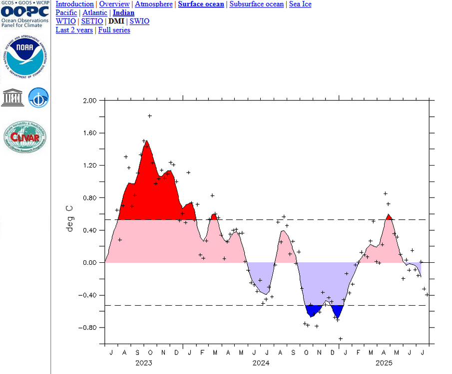
-
You don't need to look far to see why Erin is struggling convectively this morning. First, it's still in a marginally favorable SST environment Second and more important, it is plowing into an area of drier, more stable atmospheric conditions--something that was anticipated days ago. The microwave image I posted last night was illustrative of its organization, which still exists this morning. Note the well defined center and its symmetrical nature. Note also the more stable conditions to its northwest. This should keep Erin in check for a bit, but given the internal organization, if that doesn't fade once this finds a more favorable environment it should still be primed to ramp up. As for track, I still think it's highly unlikely to directly impact the US coast, but Atlantic Canada should be monitoring more closely.
-
Thanks pasnownut!
-
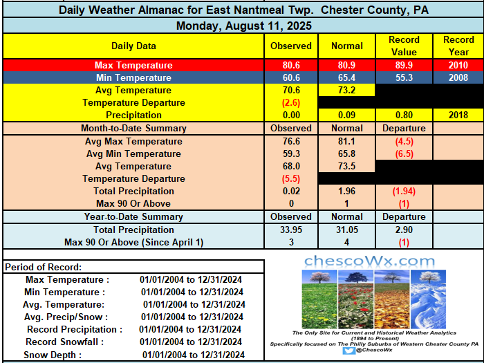
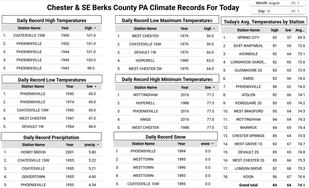
Yesterday was our 11th straight below normal temperature day here in East Nantmeal to start the month of August. Today we should finally see above normal temperatures and they look like they should last through the week and into the weekend. We should see temperatures in the mid to upper 80's for the rest of the work week and maybe reaching the 90's by Sunday. We have been dry so far this month so the potential shower later tomorrow into the evening will be welcomed by our many area farmers and green thumbs.
-

E PA/NJ/DE Summer 2025 Obs/Discussion
ChescoWx replied to Hurricane Agnes's topic in Philadelphia Region
Yesterday was our 11th straight below normal temperature day here in East Nantmeal to start the month of August. Today we should finally see above normal temperatures and they look like they should last through the week and into the weekend. We should see temperatures in the mid to upper 80's for the rest of the work week and maybe reaching the 90's by Sunday. We have been dry so far this month so the potential shower later tomorrow into the evening will be welcomed by our many area farmers and green thumbs.
-
While I understand some folks wanting to fantasize, especially during pitifully boring times, in the history of East Coast hurricane forecasting, nothing has changed! The major pattern players are always the same, as Ryan, Tip and Coastal have pointed out; anomalous positive heights in the northwest Atlantic (Newfound wheel) and troughing moving east or digging southeast from TN/OH valley region. There are other setups that can tease a coastal run, but they inevitably bend east/northeast. Of all the SNE storm patterns, the hurricane threat pattern is actually one of the easiest to pick out! And this setup would need massive changes to morph into meaningful threat. Forget about tracking every little shift in Erin's track. Look north and west for the answer!
-
The maritimes have been on a generational run. Seriously.
-
First time in nearly a week that my glasses fogged up walking outside this morning. In August, I call that a win.
-
Yeah maybe something more substantial early next week.
-
Those cicada/'saw bugs' are out there deforesting already and it's not even 9am... Heh, it 'sounds' like a hot day is in the mail.
-
 Records: Highs: EWR: 98 (2021) NYC: 97 (1944) LGA: 98 (2021) JFK: 92 (1970) Lows: EWR: 54 (1954) NYC: 55 (1889) LGA: 56 (1979) JFK: 55 (1979) Historical: Posted August 13, 2024 Records: Highs: EWR: 98 (2021) NYC: 97 (1944) LGA: 98 (2021) JFK: 92 (1970) Lows: EWR: 54 (1954) NYC: 55 (1889) LGA: 56 (1979) JFK: 55 (1979) Historical: 1752 - The following is from the Journals of the Rev. Thomas Smith, and the Rev. Samuel Deane, published in 1849. In the evening there was dismal thunder and lightning, and abundance of rain, and such a hurricane as was never the like in these parts of the world. This hurricane struck Portland, 1752: Portland, Maine: “It blew down houses and barns, trees, corn and everything in its way. Such a hurricane as was never the like in these parts of the world” — Rev. Thomas Smith (Ref. WxDoctor) Maine. 1778 - A Rhode Island hurricane prevented an impending British-French sea battle, and caused extensive damage over southeast New England. (David Ludlum) 1901: Three inches of rain fell in 40 minutes during the morning at Rancocas, NJ. A similar event occurred in the same region 99 years later. (Ref. Wilson Wx. History) 1910: Electrical storms ignited numerous forest fires in the Bitterroot Mountains of Idaho. Entire towns were burned and 163 people died, including 78 firefighters. (Ref. AccWeather Weather History) 1933 - The temperature at Greenland Ranch in Death Valley, CA, hit 127 degrees to establish a U.S. record for the month of August. (The Weather Channel) 1936 - The temperature at Seymour, TX, hit 120 degrees to establish a state record. (The Weather Channel) 1936: The temperature at Seymour, TX hit 120° to establish a state record. Altus tied the Oklahoma state temperature record by reaching 120°. The high of 109° tied the record high for the month of August at Dodge City, KS. From the 12th through the 24th, there was a record 13 days on which temperatures reached 100° or more at St. Louis, MO. (Ref. The Weather Channel) (Ref. WxDoctor) 1955 - During the second week of August hurricanes Connie and Diane produced as much as 19 inches of rain in the northeastern U.S. forcing rivers from Virginia to Massachusetts into a high flood. Westfield MA was deluged with 18.15 inches of rain in 24 hours, and at Woonsocket RI the Blackstone River swelled from seventy feet in width to a mile and a half. Connecticut and the Delaware Valley were hardest hit. Total damage in New England was 800 million dollars, and flooding claimed 187 lives. (David Ludlum) 1955: The greatest DAILY precipitation to occur in the month of August or any month in Richmond, Virginia was 8.79 inches from Hurricane Connie. (Ref. Richmond International Airport Records) 1982: Sparta, WI recorded their coldest August temperature with 32°. This is also their earliest freezing temperature. La Crosse, WI set a record low with 46 °F.: (Ref. Wilson Wx. History) 1985: The "New Lisbon Tornado" F2 tornado set down south of Kendall, WI, destroying a barn and damaging a home before moving northeast into Juneau County. The tornado moved from the countryside into New Lisbon, ripping through a trailer court on the northern edge of town before dissipating on the north edge of Castle Rock Lake. A couple was killed and 22 others were injured in Juneau County. Numerous trees and power lines were downed, including 100 acres of forest at Buckhorn State Park. Over $620,000 in damage occurred. (Ref. Wilson Wx. History) 1987 - Early afternoon thunderstorms in Arizona produced 3.90 inches of rain in ninety minutes at Walnut National Monument (located east of Flagstaff), along with three inches of pea size hail, which had to be plowed off the roads. (The National Weather Summary) (Storm Data) 1988 - Fifteen cities in the northeastern U.S. reported record high temperatures for the date. Youngstown OH reported twenty-six days of 90 degree weather for the year, a total equal to that for the entire decade of the 1970s. (The National Weather Summary) 1989 - Thunderstorms were scattered across nearly every state in the Union by late in the day. Thunderstorms produced wind gusts to 75 mph at Fergus Falls MN, and golf ball size hail and wind gusts to 60 mph at Black Creek WI. In the Chicago area, seven persons at a forest preserve in North Riverside were injured by lightning. (The National Weather Summary) (Storm Data) 1993: The Great Mississippi River Flood continued as flood waters flowing past Tarbert Landing, , MS reached 832,000 cubic feet per second, which is nearly 4 times the normal August flow. (Ref. AccWeather Weather History) 1999: Severe thunderstorms developed in west central Illinois during the early evening, and moved to the Indiana border during the next several hours. Winds gusting over 80 mph caused over $50 million dollars in crop damage to Schuyler, Mason, Menard, Logan, Cass, Morgan and Scott Counties. Miles of power lines were blown down in Cass County, and numerous trees were damaged through the area. (Ref. Wilson Wx. History) 2000: Three inches of rain fell in 40 minutes during the morning at Rancocas, NJ. A similar event occurred in the same region 99 years before. (Ref. Wilson Wx. History) 2001: An Amelia County, VA man was struck and injured by lightning in his home after lightning hit a porch railing and jumped to the door he had been holding. (Ref. Lightning - Virginia Weather History) Overnight rains up to 8.4 inches in Sussex County, Delaware led to failure of a dam on Hearns Pond during the early morning. Historic Hearns and Rawlings Mills were heavily damaged, along with roads and buildings, with damage at $1.1 million dollars.(Ref. Wilson Wx. History) 2004: Hurricane Charley was the third named storm and the second hurricane of the 2004 Atlantic hurricane season. Charley lasted from August 9 to August 15, and at its peak intensity, it attained 150 mph winds, making it a strong Category 4 hurricane on the Saffir-Simpson Hurricane Scale. It made landfall in southwestern Florida at maximum strength, making it the most powerful hurricane to hit the United States since Hurricane Andrew struck Florida in 1992. 2004: Bonnie made landfall as a 45 mph (72 km/h) tropical storm just south of Apalachicola, Florida on August 12. It accelerated northeastward, and became a remnant area of low pressure on August 14 to the southeast of New Jersey. 2005 - A tornado strikes Wright, Wyoming, a coal-mining community, killing two and destroying 91 homes and damaging about 30 more in around the town.
 -
And once the system becomes convectively active again (as it did last night in the southern part of the system) we’ll have to see if that tugs the LLC in one direction or another temporarily.
-
It’s underdispursive but you get the picture.
-
yup...something to certainly watch for them and as you've stated a few times they have been a real magnet these past few years. Something which could also end up heavily influencing the weather pattern here for the last week of August.
-
Well..at least you guys saved me (us) from getting emotionally involved with this
-
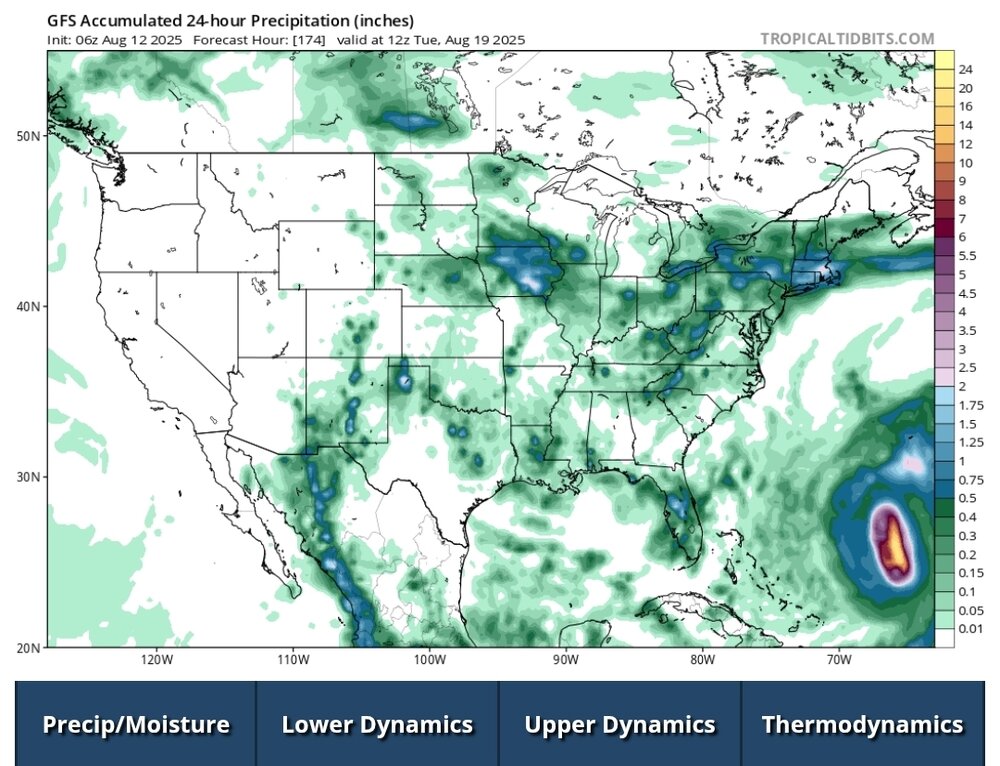
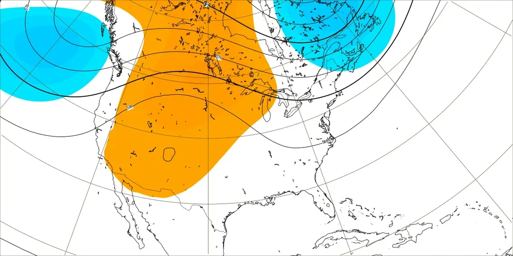
 Hopefully, we can get the Erin recurve west of Bermuda next week so the WAR gets weakened enough. Big shift to cooler on the EPS for the 18-25. Now the models have a trough along the East Coast instead of a ridge. Longer range will continue to be about the tropics. If we keep getting troughs in the East and tropical systems moving into the weakness, then maybe we can avoid 95+ heat after August 20th. But if the tropical moisture remains east, then the drought conditions will continue expanding. It’s already been the driest summer on record for spots like BDR. The tropics will continue to be the wild card into September. Since a continuing dry pattern and any lack of tropical systems and Eastern trough would allow the ridge to expand again. So the pattern could be mid-August warmth…late August closer to average…early September rebound in temperatures if we stay dry. But enhanced tropical activity in early September could push back against the heat by lowering heights over the Western Atlantic. Cooler trends for August 18-25 New runs Old runs
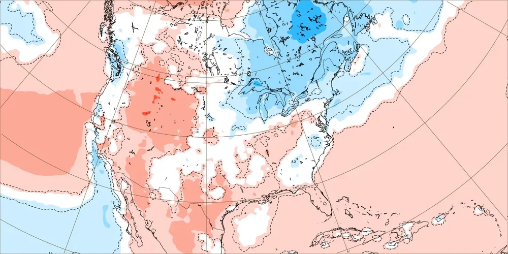

-
Another MCS rolled through eastern Iowa overnight. I received 0.82". My six-week total is about 11.5". It is very green around here.