All Activity
- Past hour
-
Juiced radar pointed right at you two.
-
Look like a strong El Nino pattern we'd see in winter, except it's still not El Nino yet!
-
"You heard it here first!"
-
Like how bad it got in the summer of 2016? An extreme drought area showed up in MA! OMG, the world ended! The Quabbin is 84% capacity now. It got as low as 79% in Dec 2016. Clickbait post.
-

Occasional Thoughts on Climate Change
donsutherland1 replied to donsutherland1's topic in Climate Change
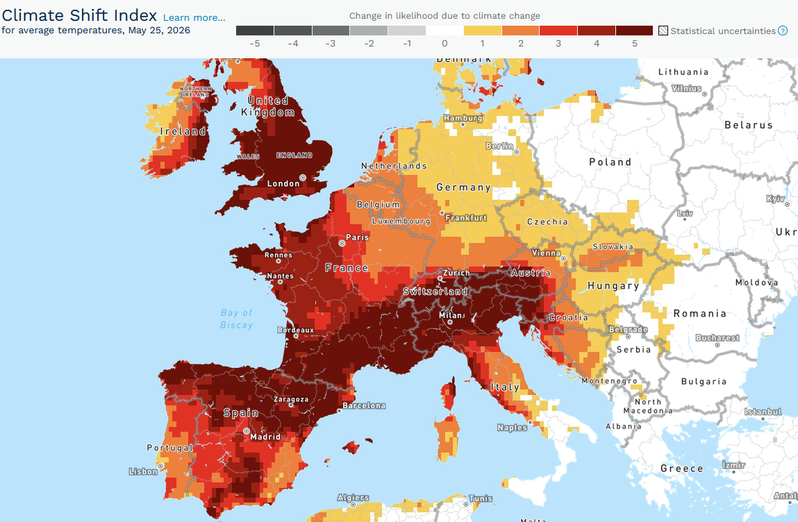
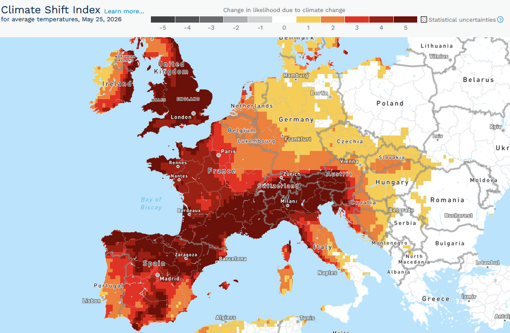
A historic May heatwave is scorching parts of Europe, including the UK, France, Germany, Italy, and Spain. Today, France saw 105 stations set new monthly records with 25 of those stations setting monthly records that had been set on Friday or yesterday. Tomorrow and Tuesday will likely be hotter. The UKs national May temperature record could be challenged or broken tomorrow and again on Tuesday. The extreme heat has been made more likely by climate change. Europe is currently experiencing a rate of warming that is twice the rate of the global average. From Climate Central's Climate Shift Index: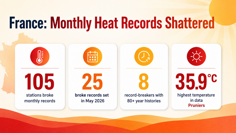
-
Meh still Steiny.
-
What else can we do but laugh at this. This very similar to that snowstorm in Feb when we got dry slotted so bad here. We got 7 days to go in the month but nothing looks like a game changer fore the piedmont region through the end of the month
-
The idea of finishing this period with <1” seemed laughable based on modeling but it’s quickly becoming reality. As is were under half the normal amount for the month
-
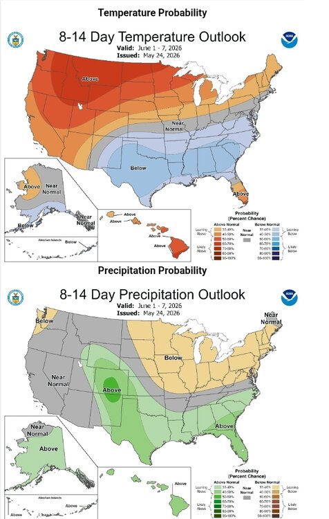
Done with this crap. Bring it on. Looks ideal.
-
For the day so far and likely to be the same for the rest of today 0.00" here. Got a small batch of rain south of Burlington, NC but thats about it for the day that is anywhere close enough to the triangle. Starting to look drier and drier the next few days too. Just pop up T storms wherever they decide to form tomorrow.
-
-
this sucks. my garden is struggling a bit with the cold following the brutal heat. as for saltwater fishing. forget it. water is frigid even when you can manage a rare calm day. today for my walk i broke out the lined hiking pants again.
-
Inch on the nose today. 1.72” for the event.
-
.55 + call from early morning looking solid . You’ll end up near or over .75. Lesson to you never, ever to partner with TFlizz and his sister wives
-
Nice steady light rain or sheet drizzle all day here and it's only 0.36"
-
Yes. It is consistent with a rapidly strengthening El Niño. New weekly numbers come out tomorrow.
-
Yeah, about half inch. Just a little under. Stuff developed. That should be about it except for isolated downpours tonight.
-
Radar is juiced down there too in SE MA. From SE CT right thru TAN up to S Wey . Nice rain train tonight .
-

2026-2027 Strong/Super El Nino
MarcmmKU replied to Stormchaserchuck1's topic in Weather Forecasting and Discussion
Totally agree. I'm an avid skier and strong ninos make my gut sink. I am praying we don't see a repeat of 2015-2016 in Vermont. Would be a disaster. -
From Raleigh east to Greenville has been the looser so far. Only 0.21" for me so far. Hoping I can cash in Tomorrow.
-
Feels like the hand wringing gets worse now with rain compared to snow. We are all getting old haha.
-

Central PA Spring 2026 Discussion/Obs Thread
Blizzard of 93 replied to Voyager's topic in Upstate New York/Pennsylvania
Welcome Home! I hope the rest of your trip was great! -
Central PA Spring 2026 Discussion/Obs Thread
Blizzard of 93 replied to Voyager's topic in Upstate New York/Pennsylvania
Mist has returned to Marysville this evening out ahead of the next line of showers approaching for later this evening. -
Miss south unless one of the cells can hold it together after sunset. Sky looks great though
-

2026-2027 Strong/Super El Nino
michsnowfreak replied to Stormchaserchuck1's topic in Weather Forecasting and Discussion
Same here in the Great Lakes- strong ninos usually are bad news. But its all relative. Winters in the Lakes and interior northeast are much harsher than the coast. So winter is more often characterized as a whole versus the coast where one huge storm (or lackthereof) often makes or breaks the winter. So basically, I already know im going to have winter, its just highly likely I'll get less of it than usual. Whereas those along coast from NYC south to the midatlantic wont be surprised in April 2027 if they've just seen a 5" winter with no storms or a 35" winter thanks to a massive storm.