All Activity
- Past hour
-

2026-2027 Record-breaking El Nino
forkyfork replied to Stormchaserchuck1's topic in Weather Forecasting and Discussion
but the stratosphere! -
glad we don't live there if you are fortunate today, your travels will take you beyond the dullness of your locale
-

2026-2027 Record-breaking El Nino
LakePaste25 replied to Stormchaserchuck1's topic in Weather Forecasting and Discussion
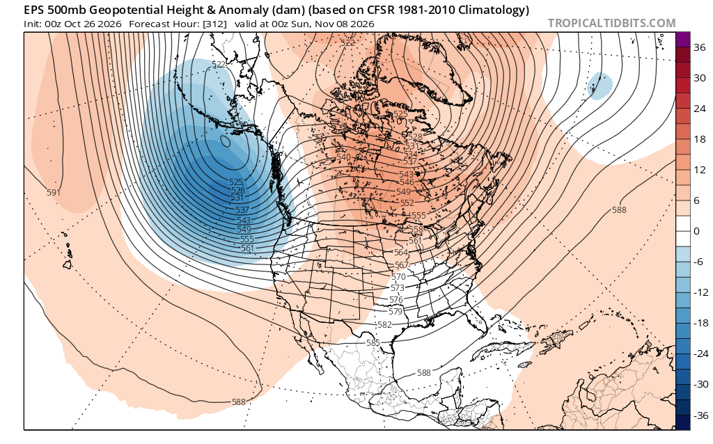
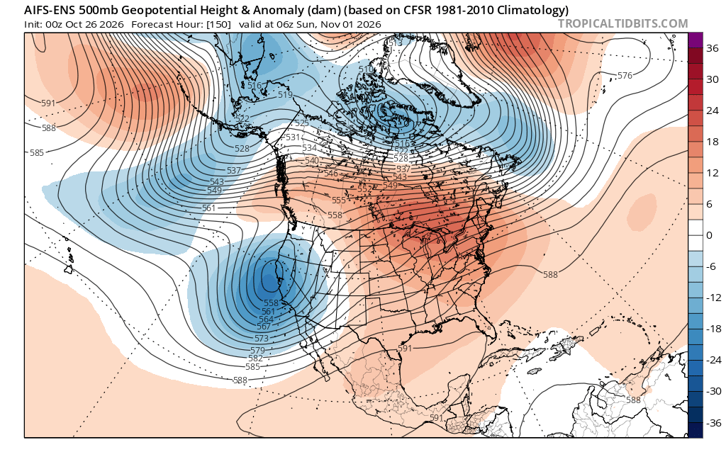
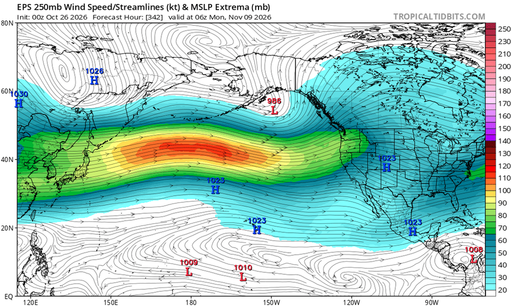
incredibly early in the season to be seeing this pattern.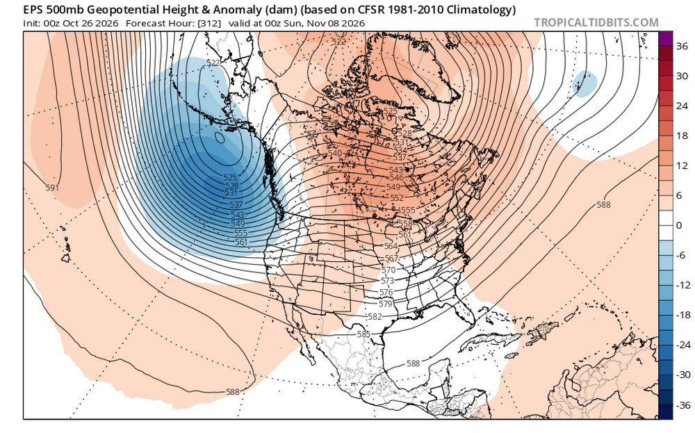
-

2026-2027 Record-breaking El Nino
Typhoon Tip replied to Stormchaserchuck1's topic in Weather Forecasting and Discussion
One aspect I've been coveting that has me deeply concerned for the state of public mental health/America Forum winter zealotry ( eh hm), is a notion that I haven't heard any one or source mention. Speculatively: the STJ may end up N of the climatological normal latitudes - as a mean ... For the general reader ... try to be nuanced aware and open idiosyncratic minded about how nature actually works for a minute here. We're talking about integrating behaviors, an integral that will end up containing examples both subtle and gross. It may not be overly obvious at all times... Sometimes yes, other times no. But in that integrated mean, could suggest a "lean" on the polar side of canonical. Events tend to go left (say). Warm penetration events a bit more robust than mid range model means - I suspect AI sources, which don't bear any compunctions ( haha ) would be unabashed. Something like that is already tantalizingly suggestive in the current Euro-AI version matter of fact... As an aside, something I'm noticing about AI so far in it's techno-infancy ... it seems to be on the amplified lean of all possibilities when looking at specifics. If whatever aspect is driving the -PDO continues, I still personally believe that needs to persist. That "tension" may be our best hope for that population of d-drippers has to happen to prevent voting self-destructively for the wrong people. haha. No but (CC base +historic positive ENSO)/2) doesn't otherwise intuitively feel hopeful if operating on the hemisphere alone. -
You're right, we don't want to clutter this thread up with climate change nonsense 52 degrees along the Mason-Dixon line this morning.
-

2026-2027 Record-breaking El Nino
40/70 Benchmark replied to Stormchaserchuck1's topic in Weather Forecasting and Discussion
In the seasonal mean? No....I don't think so. I mean, technically speaking, it's basin-wide now, but I would certainly consider it heavily eastern biased...it will probably grow somewhat more evenly distributed around mid season before perhaps collapsing back eastward early next spring. -
 farmacia pharmacy mexico generic drugs: mexico pharmacy order online free shipping - online mexico pharmacy
-

2026-2027 Record-breaking El Nino
soadforecasterx replied to Stormchaserchuck1's topic in Weather Forecasting and Discussion
Would basin wide still be on the table? -
I'm saying the 3 years since 2023. It has been all downhill from there. Both 2023 teams were false peaks-- Orioles 24 season had a winning record but sucked the second half and embarrassingly mentally feckless in the Wild Card. Ravens 24 season had blown leads and obviously the Andrews drop in the playoffs Orioles 25' season: Awful. Ravens 25' season: Awful Orioles 26 season: New manager, inherited mentally weak mentality, failed to capitalize on momentum each time, .500 team, missed playoffs. Ravens 26 season: New HC, inherited bad mentality--no dawg in 'em Looks to be a .500 season missing the playoffs. One embarrassment after another and nobody has known how to win. Now in both cases...both new manager and new HC could very well do better in 2027...but time will tell. 2027 is gonna be a defining year for Baltimore sports: Either we'll finally be released from this prison of mediocrity, or we'll be suffering for more years to come.
-
2026-2027 Record-breaking El Nino
40/70 Benchmark replied to Stormchaserchuck1's topic in Weather Forecasting and Discussion
No, it's not going to turn into a Modoki...I agree that that is laughable at this point. -

2026-2027 Record-breaking El Nino
bluewave replied to Stormchaserchuck1's topic in Weather Forecasting and Discussion
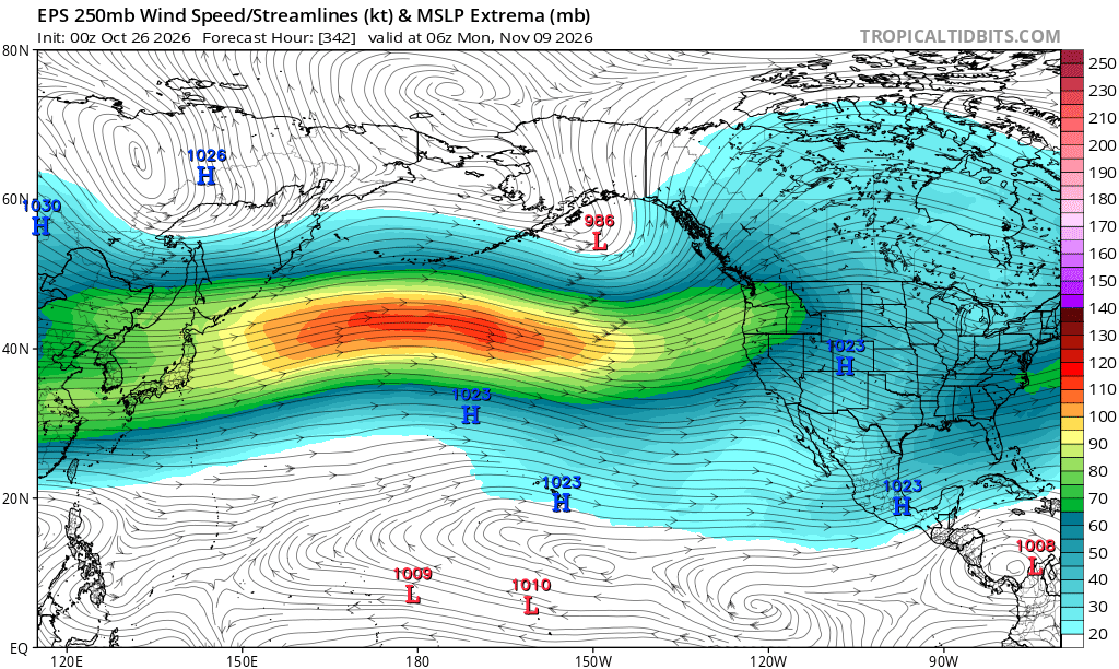
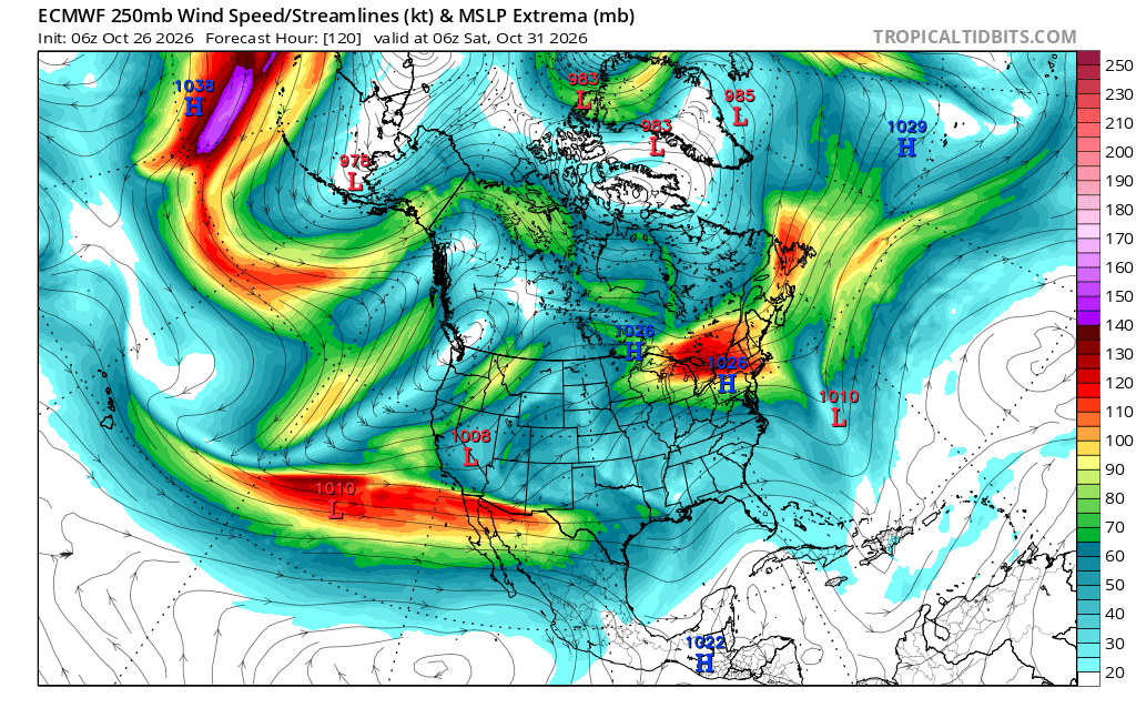
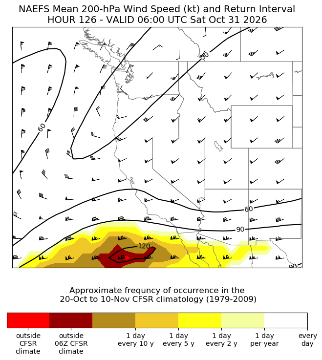
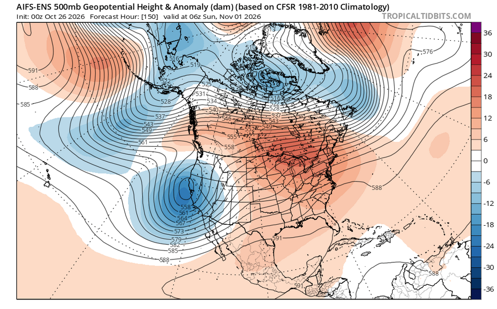
That’s a near record STJ off the Baja being forecast which will help to amplify the ridge over the Great Lakes and Northeast moving into early November.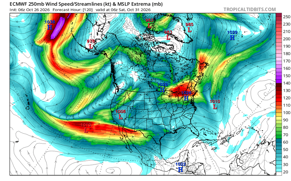
-
canadian drugstore online: CanPointe - pharmacies in canada that ship to the us
-
2026-2027 Record-breaking El Nino
40/70 Benchmark replied to Stormchaserchuck1's topic in Weather Forecasting and Discussion
Yes, that is the dual forcing I have been alluding to...it's from about 130-150 degrees longitude....I think early on, the eastern node will dominate, then we will see more variability beginning beyond the ides of January, as that western node starts to constructively interfere with some other aspects at higher latitudes in addition to ENSO perhaps leaking westward a bit overall/weakening at that juncture. -
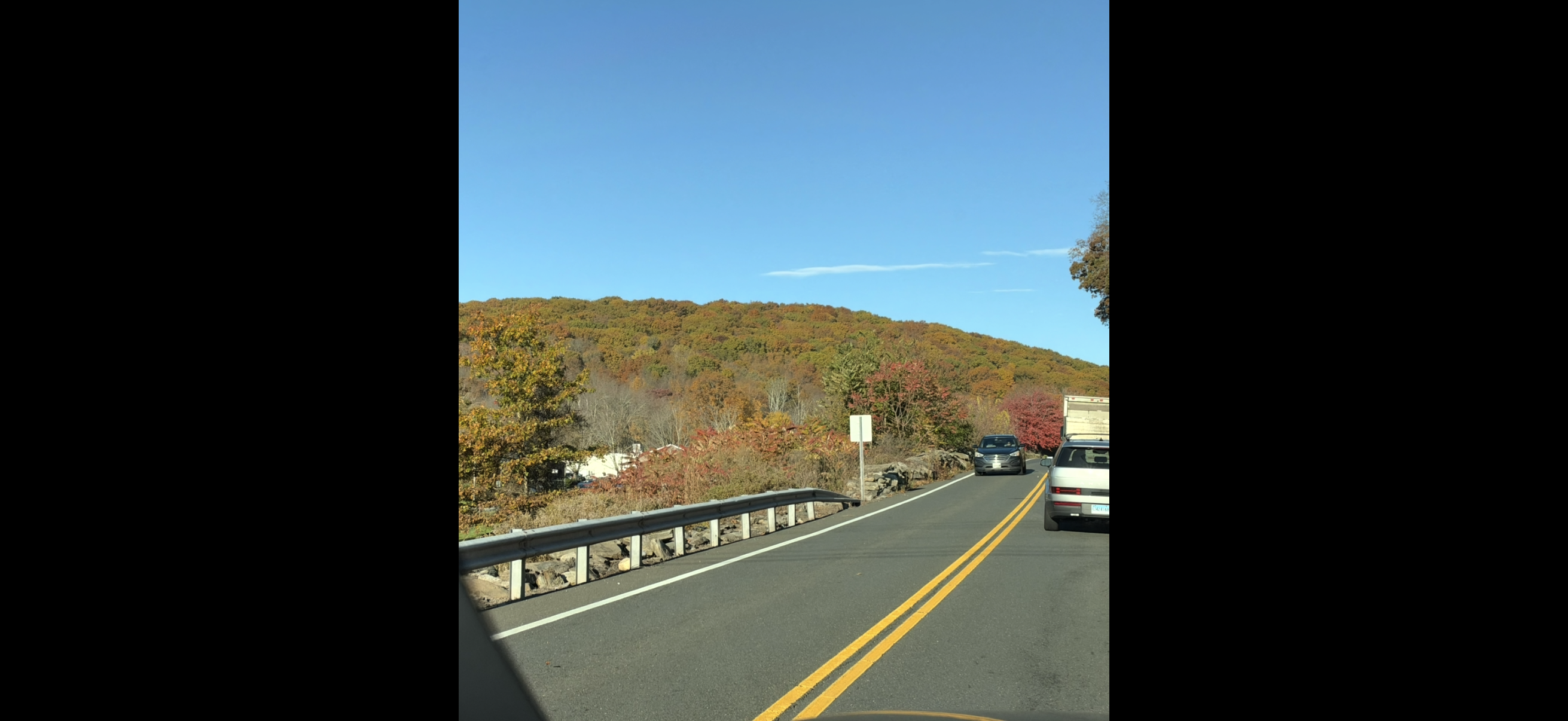
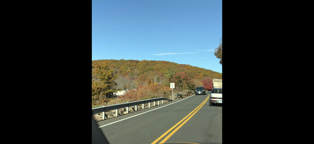
Depends on where you are I guess-we have alot of red here on the leaves
-
I know you were drunk here but here’s a picture of my hill this morning . That area where I took it just past the town Green where they have had several frosts. As anyone can see , the trees are loaded and the color is mostly brown and oranges .
-
I wouldn't even speculate on any weather model outputs past 5 -10 days at this point because of the rising potential of a SSW event as noted by the chart I just posted - models will be playing a game of catch up as the results of the SSW and results usually begin translating to the surface about 2 weeks later..........
-
no complaints here. LOVE mild, dry November days!
-
70's Friday? keep it coming
-
TORCH this week!
-
Ridge(y) east but still suspect we are not as dry and may deal with cut off under the ridge 11/5 - 11/11
-
Good stuff. At this point, I'm particularly interested in whether we can get any meaningful downstream troughing into the eastern U.S. as we head into the second half of November. Obviously, it's still early in the season, but we've seen November snowfall in Tennessee before, even if it's relatively rare. Curious whether this persistent IO forcing could eventually help shake up the pattern enough to open the door for some early-season cold.
- Today
-
36.2 in Muttontown & 38.8 in Syosset this morning.
-
2026-2027 Record-breaking El Nino
Typhoon Tip replied to Stormchaserchuck1's topic in Weather Forecasting and Discussion
Fwiprobablynotworth ... this ACME road-runner show quality graphic over at CPC seems to suggest there's a secondary +anomaly node ( if not primary...) situated around the 3.4 ... interestingly trying to connect to the marine heat wave going on around San Diego ... The nearby coastal cooling astride El Salvador - I suspect - is an artifact of the enhanced TC trafficking over the last 1.5 months running up just W of that area and imposing offshore SS stressing ..speculation.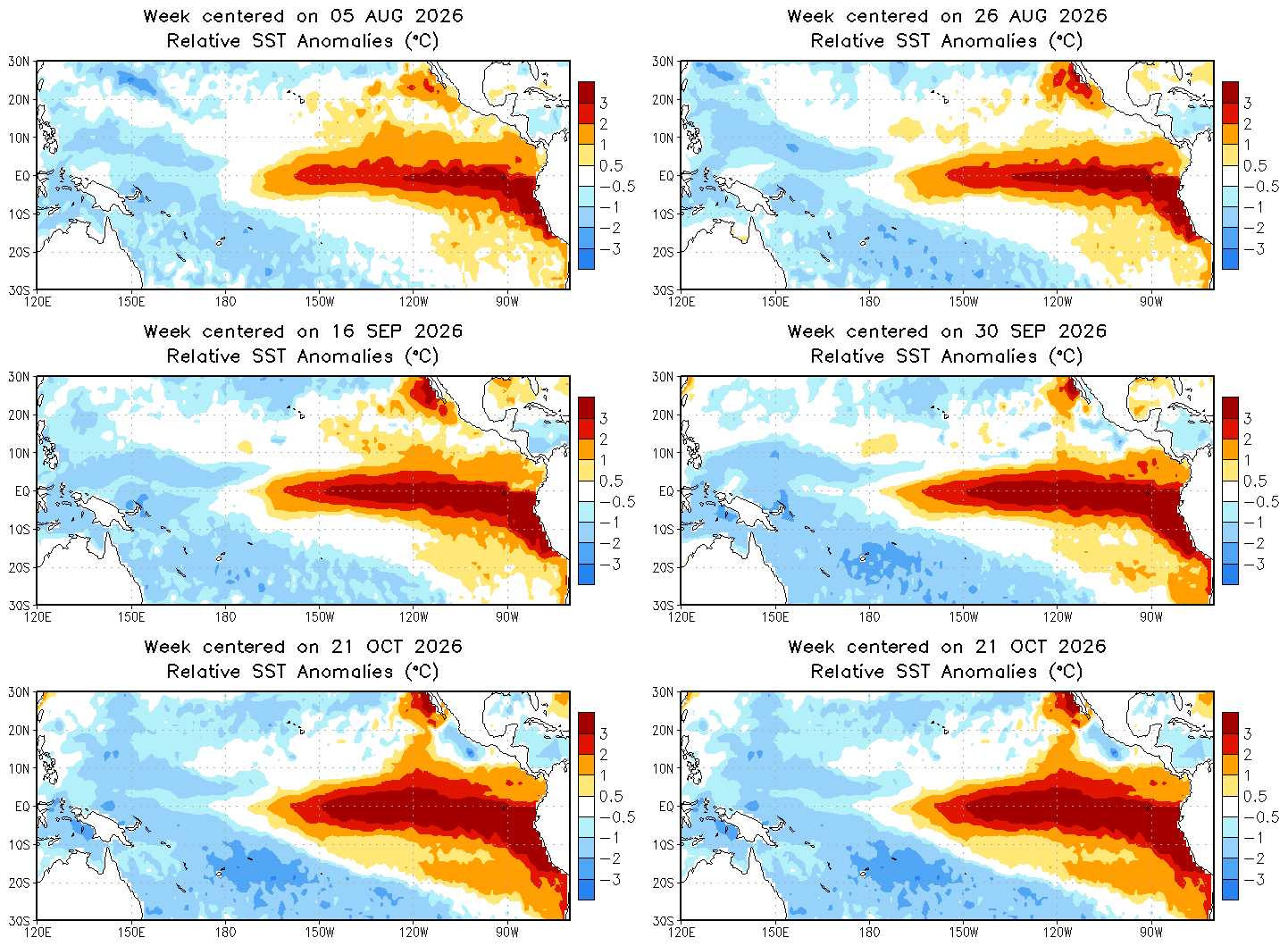
-
Records: Highs: EWR: 82 (2023) NYC: 78 (1964) LGA: 80 (2023) JFK: 78 (1971) Lows: EWR: 31 (1952) NYC: 30 (1879) LGA: 34 (1962) JFK: 32 (1962) Historical: 1859 - New York City had their earliest substantial snow of record as four inches blanketed the city. (David Ludlum) 1865: A hurricane sank the steamship USS Mobile off the Georgia coast. The wreck, laden with 20,000 gold coins, was found in 2003. 1879: Boston, Massachusetts had a low temperature of 25 °F on October 26th the coldest temperature for October. Also another 25 °F low was recorded on October 27, 1936. (Ref. NOAA Boston Weather Events) 1919 - The temperature at Bismarck, ND, plunged to ten degrees below zero, the earliest subzero reading of record for the city, and a record for the month of October. (The Weather Channel) 1926 - Barrow, AK, received a record fifteen inches of snow, and also established a 24 hour precipitation record of 1.00 inch which lasted until the 21st of July in 1987. (The Weather Channel) 1952: There have been thousands of weather reconnaissance and research flights into hurricanes in the Atlantic and Pacific since the mid-1940s. There have been several close calls, but only four flights have been lost. A B-29 Super-fortress flight into Super Typhoon Wilma 350 miles east of Leyte in the Philippines disappeared on this date. No trace was ever found of the plane or crew. In the last report, the flight was in the Super typhoon's strongest winds, which were around 160 mph. 1962 - A storm brought five to six inches of snow to Vermont and New Hampshire, with up to ten inches reported in the mountains. (The Weather Channel) 1962: An early season snowstorm hit New England with the most snow over interior sections. Greenville, ME recorded 13.9 inches Worcester, MA recorded 4.7 inches and Portland, ME had 3.6 inches. All of these amounts were new records for the greatest amount of snow for so early in the season. (Ref. AccWeather Weather History) Canadian high pressure ushered record cold from the northern Plains to the Southeast. Rockford, IL at 18° recorded their coldest October temperature. Other daily record lows included: Beckley, WV: 18°, Cincinnati, OH: 19°, Dayton, OH: 21°, Mansfield, OH: 21°, Huntington, WV: 21°, Springfield, IL: 22°, Columbus, OH: 23°, Lexington, KY: 23°, Akron, OH: 24°, Charleston, WV: 24°, Lynchburg, VA: 25°, Pittsburgh, PA: 25°, Raleigh, NC: 27°, Charlotte, NC: 29°, Atlanta, GA: 30°, Athens, GA: 31°, Montgomery, AL: 32°, Wilmington, NC: 32°, Charleston, SC: 33°, Savannah, GA: 34° and Norfolk, VA: 36°. (Ref. Wilson Wx. History) 1968: Canadian high pressure system behind a strong cold front brought chilly temperatures to the Southeast. Cross City, FL reported and all-time October record low of 30°. Other daily record lows included: Nashville, TN: 27°, Paducah, KY: 28°, Chattanooga, TN: 29°, Birmingham, AL: 29°, Atlanta, GA: 29°, Montgomery, AL: 31°, Macon, GA: 32°, Tallahassee, FL: 35°, Baton Rouge, LA: 37°-Tied, Pensacola, FL: 40°-Tied and Vero Beach, FL: 50°. (Ref. Wilson Wx. History) 1983 - A heat wave was in progress over the Northern Rockies, with record highs of 81 degrees at Sheridan WY and Billings MT.(Sandra and TI Richard Sanders - 1987) 1987 - Five cities in south central Texas reported record high temperatures for the date, including Corpus Christi and Del Rio with readings of 93 degrees. Laredo TX was the hot spot in the nation with a high of 98 degrees. Thunderstorms moving over the Lower Mississsippi Valley deluged Lake Charles LA with 2.70 inches of rain in one hour resulting in severe local flooding. (The National Weather Summary) (Storm Data) 1997: An autumn snowstorm pummeled central and south-central Nebraska with record early season snows. Wind-driven snowfall amounts totaled as much as two feet by storms' end. Several highways were closed, including Interstate 80, as near-blizzard conditions developed. Once the snow subsided, the record early season snow totals were tallied. Guide Rock measured twenty-four inches of snow, Clay Center twenty-three inches, and Hastings seventeen inches. A fifty-mile wide swath of snow more than fifteen inches fell from near Alma to York. Amounts further north averaged from four to eight inches. The heavy, wet snow was responsible for many power outages in the area as tree limbs broke and fell on power lines. At one point, the town of Hardy had no power and could not be accessed by vehicles due to the snow. Numerous schools and businesses remained closed several days following the storm. Many highways, including Interstate 80, closed at the height of the storm. On Highway 136 east of Alma, road crews worked for ten hours carving through a ten-foot drift that covered the road. Record cold accompanied the snow as temperatures dropped to the single digits on the morning of the 26th. 1988 - Thunderstorms moving out of northern Texas spawned five tornadoes in Louisiana during the morning hours. The thunderstorms also produced wind gusts to 75 mph at Jennings LA, and the driver of a vehicle was killed by a falling tree near Coushatta LA. Snow squalls in the Lower Great Lakes Region produced heavy snow in western New York State, with 12 inches reported at Colden. (The National Weather Summary) (Storm Data) 1989 - Unseasonably warm weather continued in the north central U.S. Afternoon highs of 78 degrees at Alpena MI, 75 degrees at Duluth MN, 79 degrees at Fargo ND, 77 degrees at International Falls MN, 76 degrees at Marquette MI, 75 degrees at Sault Ste Marie MI, and 80 degrees at Saint Cloud MN, were all the warmest of record for so late in the season. Morning lows of 63 degrees at Concordia KS and Omaha NE were the warmest of record for the date. (The National Weather Summary) 1997: Scientists discovered a massive "blowdown" of 20,000 acres of spruce trees in north-central Colorado. 31 square miles of old-growth forests high in the Rockies were destroyed by unusual "mountain wave" clouds that blew 120 mph winds along the western side of the Continental Divide as a major blizzard pounded the Plains from the through the 26th. Behind the storm, record low temperatures were reported across the Plains including: Scottsbluff, NE: 0°, Rapid City, SD: 2°, Goodland, KS: 10°, Grand Island, NE: 13°-Tied and Omaha, NE: 21°-Tied. (Ref. Wilson Wx. History) 1998: Hurricane Mitch, the second deadliest hurricane in the Atlantic Ocean, reached Category 5 strength on this day. 2002: The football game between the Richmond Spiders and Rhode Island was suspended due to a flooded field at Meade Stadium in Kingston, RI. The field began to become covered with water during the first half, but a halftime downpour covered the entire field. Water was knee deep on parts of the field and no grass was visible by the time the game was suspended. (Ref. Wilson Wx. History) 2005: The summit on Mt. Washington, NH received an additional 27.5 inches of snow during the overnight to break their 24-hour snowfall record set just 9 days earlier. During the previous 12 days, 72 inches fell, nearly 25 % of the normal yearly total. (Ref. Wilson Wx. History) (Ref. WxDoctor)
-
Lots of mid level clouds here. Still 37.6°