All Activity
- Past hour
-
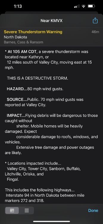
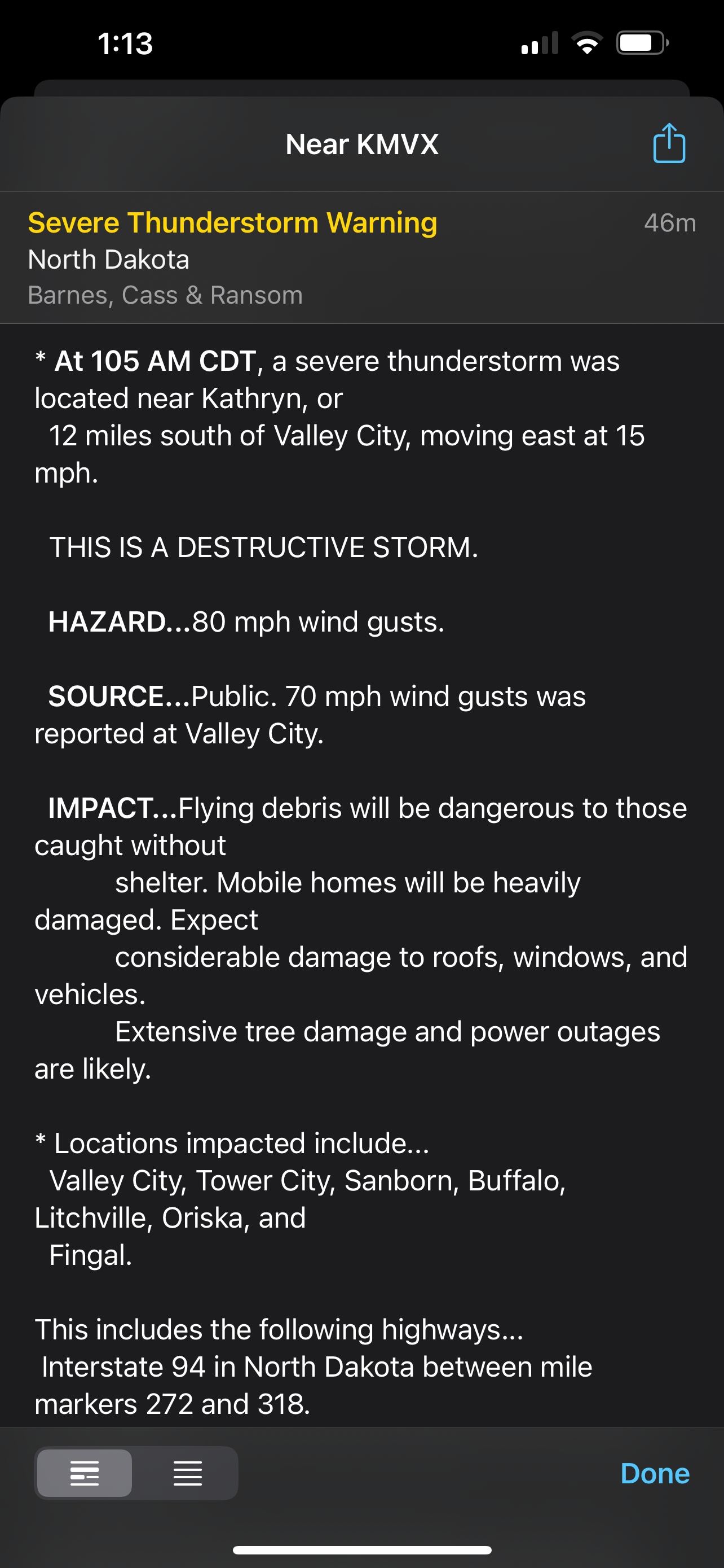
Even this gust front got a severe thunderstorm warning with a “destructive” tag. It’s incredible how much wind energy there is.
-
Iowa Derecho 2.0
- Today
-
99 percent of Liberty’s posts are insane and ridiculous
-
Liberty gonna Liberty
-

E PA/NJ/DE Summer 2025 Obs/Discussion
PhiEaglesfan712 replied to Hurricane Agnes's topic in Philadelphia Region
It's officially Go Birds season when we see this in the forecast. -
As a strong believer in climate change and global warming I think this is ridiculous and outrageous. There have been heatwaves going way back. By allowing yourself to rate climate change according to the weather on a day or two you are promoting the ability of deniers to come back when it snows or is cold for a day or two and say, "see there's no climate change". It's absurd and it is NOT what climate change is. It is far bigger and based on statistics globally over 100s of years. It is not a hot day or a snowstorm. WX/PT
-

2025-2026 ENSO
40/70 Benchmark replied to 40/70 Benchmark's topic in Weather Forecasting and Discussion
Agree. I don't necessarily mean a frigid December...just active and not prohibitively warm. -

2025-2026 ENSO
Stormchaserchuck1 replied to 40/70 Benchmark's topic in Weather Forecasting and Discussion
I agree, I also think there is an above average tendency for -EPO periods to happen with +NAO.. that is an above average precip pattern in the eastern 1/2. Clippers have become less common though, so the low pressure will likely need to tap into the Gulf. I'm getting a few warm things for Dec, although I know the small sample of -Neutral ENSO and -QBO favors a cold December. -
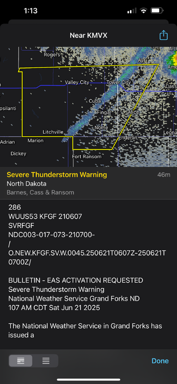
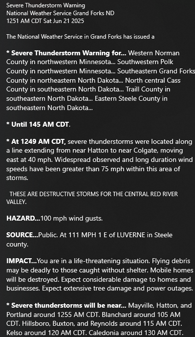
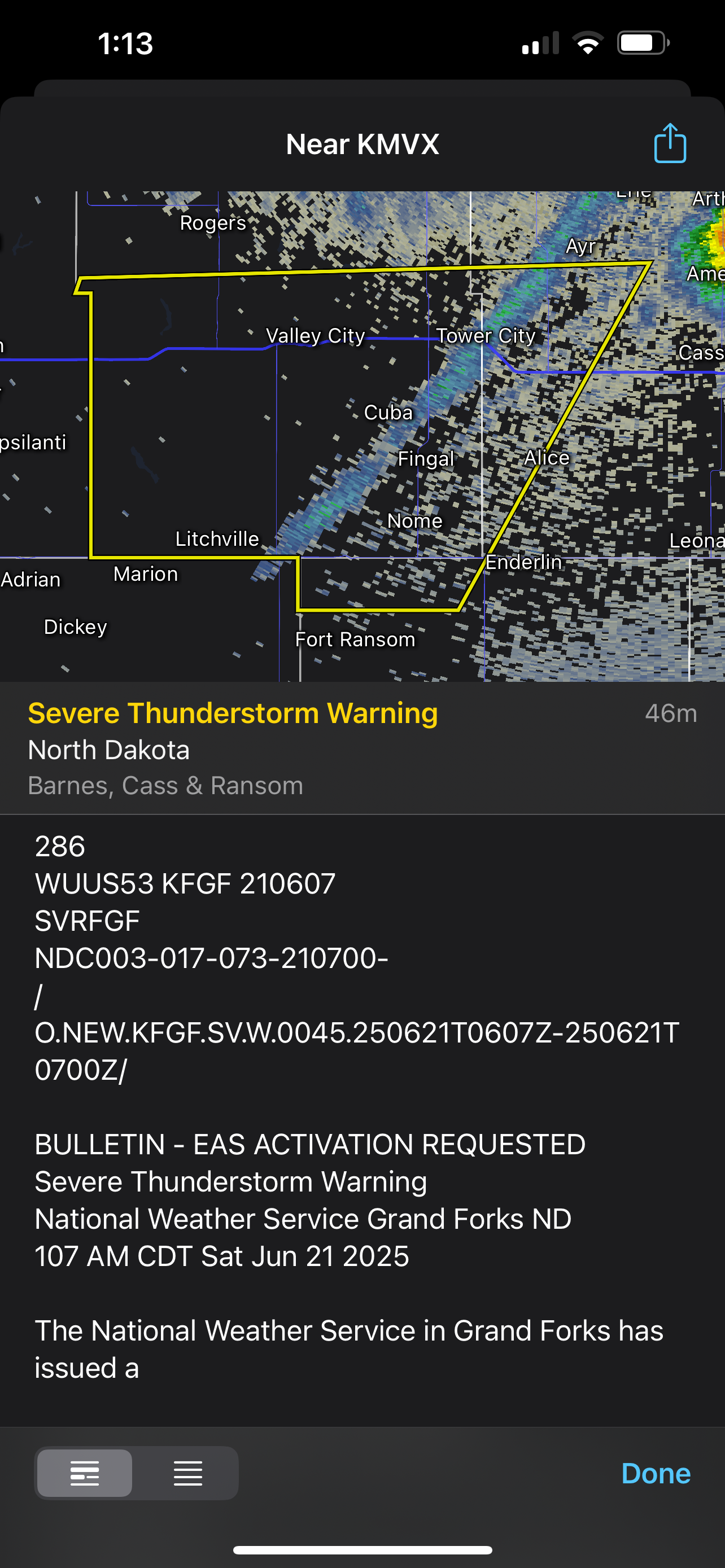
Warnings for 90 mph winds in North Dakota currently
-
2025-2026 ENSO
40/70 Benchmark replied to 40/70 Benchmark's topic in Weather Forecasting and Discussion
I also think we may see a pretty fast start this December...will get into why later in the season, but it originates from the QBO/solar stuff. -
2025-2026 ENSO
40/70 Benchmark replied to 40/70 Benchmark's topic in Weather Forecasting and Discussion
I think the common denominators will be poleward ridging in the Pacific and pronounced period(s) of negative NAO in the midst of a decidedly +NAO season....-PNA likely hits hardest when the -NAO shows up, which should allow for a much more active storm track in the NE. -
This is not correct. No other stations were 82. Sacrus posted the numbers.
-
Is there wildfire smoke out there? Super smoky smell but I guess it could be a neighbor’s fire pit.
-
already feeling super gross outside with PTK reporting 71/66 as of 11PM. the brief rain showers this morning (0.11" imby) and stagnant overcast has led to a yuckening of the night that I can only describe as "wearing soup" or "sweaty underpants" my dehumidifier is going full BTO, takin' care of business (and working overtime, wooo)
-

E PA/NJ/DE Summer 2025 Obs/Discussion
Kevin Reilly replied to Hurricane Agnes's topic in Philadelphia Region
No power still 35 hours and counting no restoration time estimated. -
2025-2026 ENSO
Stormchaserchuck1 replied to 40/70 Benchmark's topic in Weather Forecasting and Discussion
Nice write-up Ray. I like how you touched on the PNA and PDO and how we are still riding hard in the negative phase of them. There are actually a lot of similarities to last Winter this year.. last Winter the strong -PDO didn't really correlate.. should be interesting to see what happens this year with near similar PDO, ENSO, and still an active sun. -
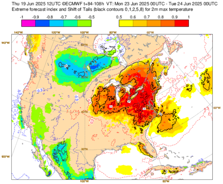
Summer’s officially here! Make the most of it, folks.
-
Just past 10:42pm. The sun has gotten as far north from the equator as it will ever be this year over the western Pacific Ocean! @CAPE Your worry about your lawn being incinerated will soon be on borrowed time as the solar noon sun angle eventually lowers behind your trees. Hot summer weather lovers rejoice for your time of celebration has come! Cold weather lovers you all rejoice as well for the days will get shorter with the sun angle lowering from here on out until the winter solstice, ensuring that the heat and humid will also eventually abate.
-
Lake Clark, Lake Aldred, and especially Conawingo reservoir all can experience three even four foot white caps every few years if the winds blow up the river correctly. We had a few guys get swamped and overturned in a tortament on Lake Aldred in 2011 from a pop up storm, one was in a 24 foot sea ark. I also saw a group almost get blown over Holtwood dam during a storm before the flashboards were put up because there outbord was way underpowerd for the Pontoon, and they didn't know to put down their bimini in wind. The river can change quick and take life in a heartbeat along with the people that have to attempt the rescue. The Sus is a heartless killer.
-
One of my favorite things in life. That particular south Florida smell, the heat. Something unmistakable at FLL.
-
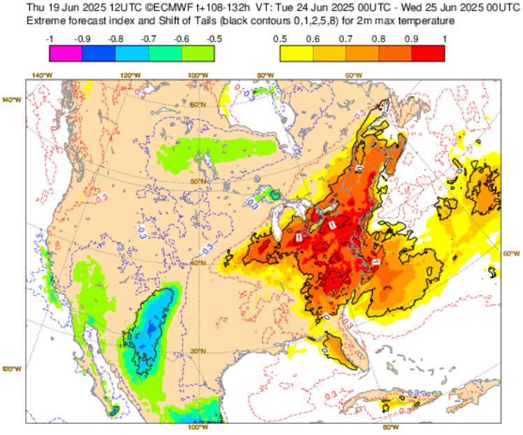
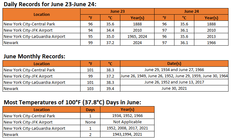
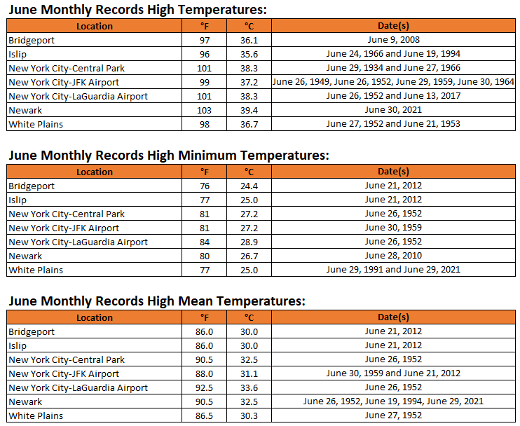
Expanded lists of June record high maximum, minimum, and mean temperatures for the New York City area are below:
-
Hrrr trying to ruin Sunday heat with debris clouds
-
I'm seeing mid 80s right along the coastline.
-

2025 Short Range Severe Weather Discussion
MidwestChaser replied to Chicago Storm's topic in Lakes/Ohio Valley
Big tornado in North Dakota right now:


.thumb.jpg.6a4895b2a43f87359e4e7d04a6fa0d14.jpg)


