All Activity
- Past hour
-

Best Mid-Atlantic winter storm of the last 50 years
Stormchaserchuck1 replied to PrinceFrederickWx's topic in Mid Atlantic
Yeah, it was a private school. I used to do weather forecasts at chapel everyday. -
Hit 78 here today. Picked up .09" yesterday and .02" this morning.
-

November 2025 general discussions and probable topic derailings ...
Ginx snewx replied to Typhoon Tip's topic in New England
Doomsdayers end the world I was talking supply chain issues. Yes inside info inside the military told me that everyone was on standby and all leave weekends were on hold. Not my fault Biden had no balls . Nice try you can tune a piano but you can't Tunafish. -

Best Mid-Atlantic winter storm of the last 50 years
bncho replied to PrinceFrederickWx's topic in Mid Atlantic
that is one hell of a flex man -
Colors are really starting to pop out here except for the Bradford Pears which usually come later anyway but the colors are much earlier than last year.
-
 I get a cider craving this time of year too, had some last weekend.
 -
 Meh, I’ve just learned to post a smaller size image.
 -

11/8-11/10 First Snow and Lake Effect Event
KeenerWx replied to Geoboy645's topic in Lakes/Ohio Valley
This map is so goofy. I get the uncertainty with lake effect. And that this map is generated with probabilistic inputs. But while technically accurate, the labels for Elgin, Joliet and Kankakee just don’t make sense with the corresponding color regions. -
A strong cold front will cross the region tomorrow bringing this season's coldest temperatures so far early next week. Its passage could trigger some showers or a thunderstorm tomorrow into tomorrow night. The temperature will likely top out in the upper 50s and lower 60s tomorrow. Following the frontal passage, lows would fall well into the 30s in New York City while highs struggle to reach the lower 40s during the height of the early-season chill on Tuesday. The Deep South could see the temperature fall to record low levels, particularly on Tuesday. Parts of Florida will likely see a freeze. The ENSO Region 1+2 anomaly was +0.1°C and the Region 3.4 anomaly was -0.6°C for the week centered around October 29. For the past six weeks, the ENSO Region 1+2 anomaly has averaged -0.05°C and the ENSO Region 3.4 anomaly has averaged -0.52°C. La Niña conditions will likely continue through mid-winter. The SOI was +18.89 today. The preliminary Arctic Oscillation (AO) was -1.254 today. Based on sensitivity analysis applied to the latest guidance, there is an implied 54% probability that New York City will have a cooler than normal November (1991-2020 normal). November will likely finish with a mean temperature near 47.6° (0.4° below normal). Supplemental Information: The projected mean would be 0.1° below the 1981-2010 normal monthly value.
-
Best Mid-Atlantic winter storm of the last 50 years
Stormchaserchuck1 replied to PrinceFrederickWx's topic in Mid Atlantic
Jan 25, 2000 is very underrated. Literally that morning, the forecast was for partly sunny with a chance of a flurry and later that day 20" fell here. My school principal used to call me for weather updates when they would consider closing the school or not. I was watching the radar at 6:30am that day, watching a huge area of precip moving NW from the ocean, and I told them, "close the schools, I think we are getting 6-12". A few hours later when it started snowing everything went 12"+. -
I mean this is in a non joking way. It’s time to discount the GFS for good. We make jokes but its performance this summer/fall as well as taking 6 days to come around to the idea the Euro had with this coming week’s setup is enough.
-
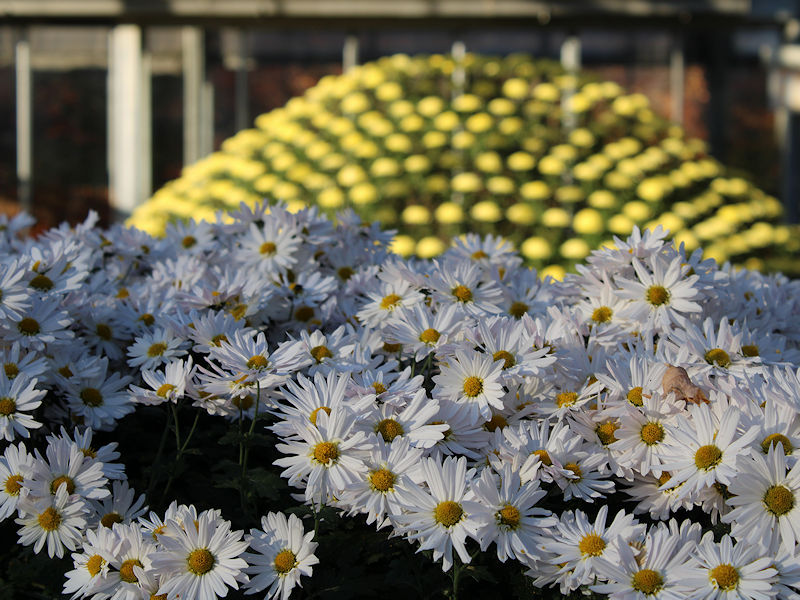
Under bright sunshine, deep blue skies, and a light breeze, the temperature soared into the lower and middle 60s across the New York City area. Some photos from the New York botanical Garden:


-

November 2025 general discussions and probable topic derailings ...
Torch Tiger replied to Typhoon Tip's topic in New England
Lol -
 It’s so maddening. You should just be able to click and upload . They changed something in the spring which doesn’t allow any outside photo sites to link directly . Just like the Twitter issue. Infuriating when you’re in a hurry especially
 -

November 2025 general discussions and probable topic derailings ...
tamarack replied to Typhoon Tip's topic in New England
3 little events resulted in 6 consecutive days with measurable rain, for a total of 0.59". Tomorrow night and Monday don't look all that different. -

Occasional Thoughts on Climate Change
Typhoon Tip replied to donsutherland1's topic in Climate Change
It was suspicious ... These two struck me as big oil moles - they may not be linked as such, but they plied the same sort of tactic that big oil used to attempt. Buyout intellectuals pay them to be lobbyists, sending them into public forums and/or legislative debates. et al, where raise points that are ultimately false, but brilliantly articulated, thus too difficult to adjudicate and/or be objectively critical of by the target audience - who by not fault of their own, are just not educated or experiences or capable. This is particularly effective when the audiences are bias to begin with, such as Rogen and his reach. He's a CC skeptic, based upon his general history, one that is more than likely influenced by a political base - a latter aspect that is evinced via his media portrait and expose' over recent years. So Lendzen wastes no time in smirkly nose laughing comments that discredit climate science, 'how can there be a huge consensus when there are so few climate scientists around' - or words to that affect. It's so patently absurd when you think that climate scientists are but a fraction of the voices. What about all the alarms from oceanographers and biologist and general environment/natural scientists, et al... what about all them? No one in his audience - for example - even knows to ask that. It's obvious these guys are specious. Or stupid. ... and then he goes on to make statements to the affect of, 'you should be suspicious of any consensus' -

November 2025 general discussions and probable topic derailings ...
IrishRob17 replied to Typhoon Tip's topic in New England
Agreed, the photos issue is also triggering now that it's almost 2026. The links work, didn't realize your lawn looked so bad, good luck with that. I kid, I kid, looking good. -
Why would I want to take the time to do that? Why can’t we just simply load a picture like other sites ? But does the link even work ?
-
November 2025 general discussions and probable topic derailings ...
Torch Tiger replied to Typhoon Tip's topic in New England
you need to trim uploaded pics down to make room for new ones upper-right corner, click your name at drop-down menu, my attachments, and delete ones that aren't needed -

Best Mid-Atlantic winter storm of the last 50 years
WEATHER53 replied to PrinceFrederickWx's topic in Mid Atlantic
We are coming up in the truely neglected Veterans Day 1987 where DCA did a rare thing and led the way for the area airports -
Dickarees? Do my pics even come thru on the link? Ever since the board changes it won’t let me post like I used to and when I try to load directly files too big
-
Welcome! If you're a football fan, how do you like Bill? My guess is that since you were not up here for the very snowy period that some here grew up with and thought was the new normal, you won't be disappointed especially when you compare a winter here with those further south.
-

11/8-11/10 First Snow and Lake Effect Event
mannynyc replied to Geoboy645's topic in Lakes/Ohio Valley
Very pretty in Grinnell, Iowa at the moment. Hopefully the lake effect bands cash in. -
upton has rain from 1pm on tomorrow but models don't have much
-
I just moved up here from central NC. Had been there my whole life aside from a year and a half in DC. And boy I’ve had my share of disappointment. Hope I’m not too late on the climate change scale to experience a snowy NYC winter. Excited to learn some of the fundamentals of this climo!


