All Activity
- Past hour
-
I do like that the NAO and AO are going down. I think around Christmas to New years will be our next threat in the east
-
Just broke over 32 degrees at 10:30 am. That is a bit over 56 hours below freezing, 42 hours under 20 and 11 hours below 10 degrees. Not a bad run before hitting the winter solstice.
-
Quick check on the ensembles today looks like a solid -pna pattern for at least the next two weeks with no credible snow threats for the MA. Perhaps some cold shots over the NE and MA. But we’re gonna have to wait this out a bit before the scand ridge retros into a GL block around new years.
-

December 2025 regional war/obs/disco thread
Damage In Tolland replied to Torch Tiger's topic in New England
This screamer is a beast -

December 2025 regional war/obs/disco thread
Go Kart Mozart replied to Torch Tiger's topic in New England
I have been noticing some interesting trends in the NHEM. The northern Caspian is already frozen, the Hokkaido ice bridge is forming, Saginaw bay is frozen, Hudson's Bay is waaaay ahead of last year (I believe full freeze up was January 17th), etc. How cold is the NHEM compared to recent trends? Is it a lot colder than "normal", or am I just being fooled by comparison to last year? -

December 2025 regional war/obs/disco thread
Ginx snewx replied to Torch Tiger's topic in New England

-
December 2025 regional war/obs/disco thread
Ginx snewx replied to Torch Tiger's topic in New England
Ain't happening James -

December 2025 regional war/obs/disco thread
weatherwiz replied to Torch Tiger's topic in New England
I wonder if we start Friday with some very dense fog -
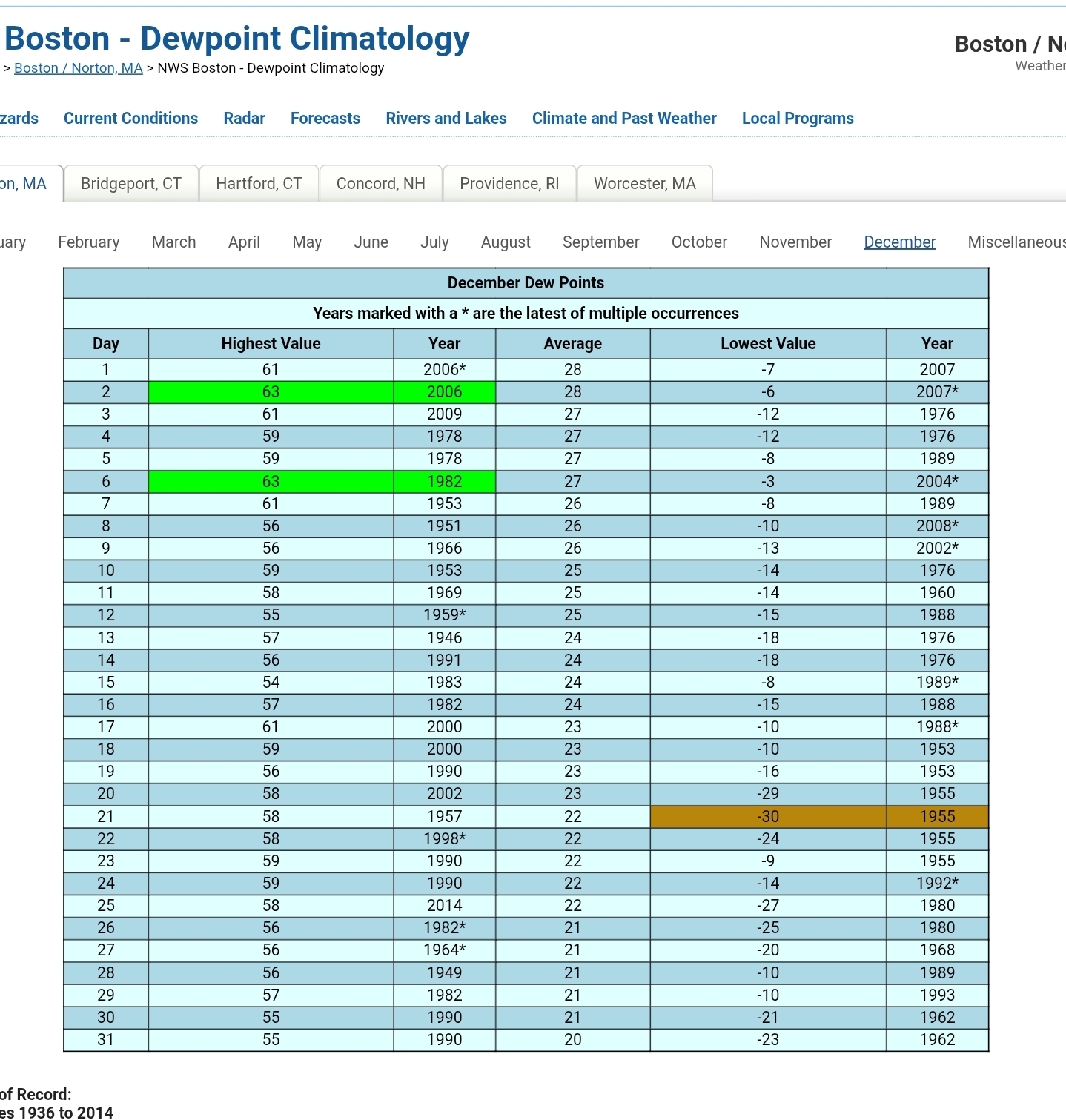
First half of the month at DLH is the 10th coldest. 3 days of warmer wx, and sloppy with the strong clipper incoming for Wed-Thurs. -4.40 1919-12-01 1919-12-15 1 1 1 0 -2.33 1972-12-01 1972-12-15 2 2 2 0 -0.27 1958-12-01 1958-12-15 3 3 3 0 1.27 1927-12-01 1927-12-15 4 4 4 0 1.33 1917-12-01 1917-12-15 5 5 5 0 3.67 1976-12-01 1976-12-15 6 6 6 0 4.50 1985-12-01 1985-12-15 7 7 7 0 5.10 2013-12-01 2013-12-15 8 8 8 0 5.30 2000-12-01 2000-12-15 9 9 9 0 6.33 2025-12-01 2025-12-15 10 10 10 0
-
-
December 2025 regional war/obs/disco thread
Damage In Tolland replied to Torch Tiger's topic in New England
You’ll come very close to 60. -

-
December 2025 regional war/obs/disco thread
Damage In Tolland replied to Torch Tiger's topic in New England
Wonder if you’ll even hit 40 -
Was 12 when I left the house in Fallston at 8 am.
-
December 2025 regional war/obs/disco thread
Ginx snewx replied to Torch Tiger's topic in New England
My experience says in this winter setup my high is 53 -
December 2025 regional war/obs/disco thread
weatherwiz replied to Torch Tiger's topic in New England
whoops...that should have just said Long Island...not the sound lol. Long Island had a nice little hit from the storm. But I guess looking deeper...it will be difficult to prevent temps/dews from climbing into the lower 50's though I am curious to see how far north we can get those. Could struggle to get the warm front to lift much past the Pike. If that sfc low either trends a bit farther southeast or a weak wave develops along the front...the warm sector would get squashed a bit. Probably would see a funny shaped front -
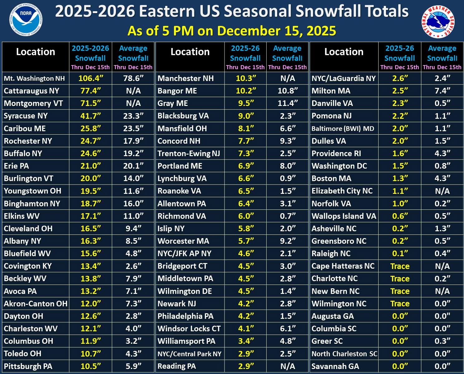
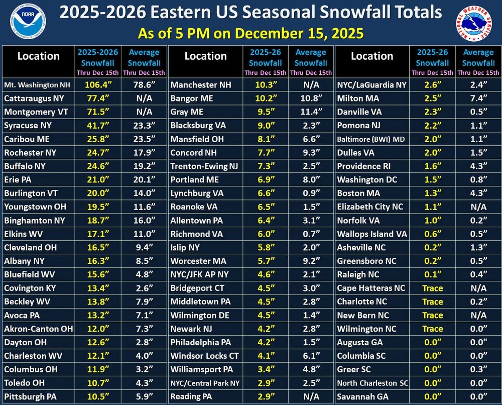
ORD anomaly for 1st to 15th is -11.3 F.
-

December 2025 Short/Medium Range Forecast Thread
Golf757075 replied to John1122's topic in Tennessee Valley
Carver, I hope we can get the ao negative at some point this winter for a little extended time. Especially the epo. For a little while also -
December 2025 regional war/obs/disco thread
Go Kart Mozart replied to Torch Tiger's topic in New England
Jeez, I've been out of town...but what happened up there? -

December 2025 Short/Medium Range Forecast Thread
Matthew70 replied to John1122's topic in Tennessee Valley
I remember awhile back the wx service out of Nashville wrote how a -AO meant cold for these parts. -
NOUS41 KOKX 161406 PNSOKX Public Information Statement National Weather Service New York NY 0906 AM EST Tue Dec 16 2025 ...NATIONAL WEATHER SERVICE NEW YORK NY TRANSITIONING TO A NEW FORMAT FOR THE AREA FORECAST DISCUSSION BEGINNING JAN 7 2026... Beginning with the afternoon issuance on January 7th 2026, the National Weather Service New York, NY Forecast Office will transition to a Key Message format for the Area Forecast Discussion (AFDOKX). This strategic change aligns the Area Forecast Discussion (AFD) with an impacts-first message philosophy, enabling our office to streamline communication and reduce redundancy. This transition moves away from a strictly chronological layout to focus immediately on potential weather impacts and hazards. By prioritizing Key Messages, we aim to enhance clarity and eliminate duplication within the Area Forecast Discussion. A side-by-side comparison of the old format and the new format templates can be found at: https://www.weather.gov/erh/newAFD The latest local AFD can be found at the following link: https://forecast.weather.gov/product.php?site=okx&issuedby=OKX&product=AFD For any questions, please contact: Nelson Vaz Warning Coordination Meteorologist National Weather Service New York NY [email protected]
-
-
You will have a snowpack left. Quick hitting, Shorter duration system, 1" or less qpf, There will still be snow left, The pack out there can absorb this, But the bigger story is going to be the wind gust ahead of the FROPA.
-
Yeah I’d put Friday's system as narrowly into Grinch territory. Usually they happen closer to Xmas but if it’s 6 days out that is prob close enough. At least we have a shot at redemption though. It would be nice to get 2 in a row after we weaseled a decent snow event before Xmas last year.
-

Central PA Winter 25/26 Discussion and Obs
Superstorm replied to MAG5035's topic in Upstate New York/Pennsylvania
Wonder if THV was ever national low?