All Activity
- Past hour
-

December 2025 regional war/obs/disco thread
mahk_webstah replied to Torch Tiger's topic in New England
I tend to like those messy systems in southern New England -
Good post. To put a fine point on the synoptic/orographic nature of this year, I am at 14.6" snowfall total here in Charlotte at 285'. With 4" OTG and a SWE of 0.6"
-

December 2025 regional war/obs/disco thread
Typhoon Tip replied to Torch Tiger's topic in New England
mm I'm thinking more along the lines of synoptic forcing/wind problems that are then entangled with convection along what's inevitably going to be a ribbon echo squall sinuously side winding across the area. I guess wind watch headlines may cover this come to think of it. Plus... any "subtle" discrete nature to leading convective elements that are embedded in the misty wind smearing rad wash region - dirty warm sector... Those'll be whisking along within a llv jet. Those could snap troubled limbs. NAM is a tad more aggressive with this llv wind max than the Euro ( 12z ) ...haven't looked that GFS. But the NAM indicated 65+kts at 925 mb between HFD-BED! That's a whopper if it's for real. But even the Euro has this wind maxim moving NYC to SE zones/clipping at 55 to 60. A compromise puts a potential momentum/gust problem across the bulk of the area. There's still still 2 days to tune this potential. But the soundings start to look more barotropic as this is all occurring and that means we scale back the protective inversion stuff... -
Cold down here in the holler at head of the crick with high of 49 and low of 21. Not a big departure but another consecutive negative 2” remaining snow over at Frederuck house doing its job, 42 max so far there
-

December 2025 regional war/obs/disco thread
weatherwiz replied to Torch Tiger's topic in New England
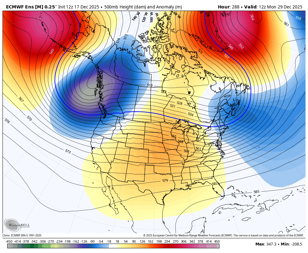
I wouldn't be shocked if that ridging in the south is too smoothed out too. I would wager probably more of a ridge axis into the upper Mississippi Valley which could then argue for some lower heights in the Northeast The overall structure of that trough across western Canada's coast will be a big player too -

December 2025 regional war/obs/disco thread
brooklynwx99 replied to Torch Tiger's topic in New England
nah i can't, which is why I think things are going to be one or the other. either more of a trough over the NE or warmer like the old GEPS runs. that's a weird in between -
December 2025 regional war/obs/disco thread
brooklynwx99 replied to Torch Tiger's topic in New England
these are also means that we're looking at... it wouldn't be shocking that there's some washing out ongoing for example. members that don't develop a strong -NAO are likely complete torches with very high E US heights. however, ones that do, and especially the ones that shift the block more west, might actually just have a cold airmass in the east. wish there was a way to look at EPS members like that -
Honestly, are there any analogs that have that look? I can’t recall that. It reminds me of those stagnant farts that just stays in the room and doesn’t disperse. Just persistent ass.
-
I'm saying we can luck into that type of setup any random winter. It's like we have a bucket of climo stuff. That includes the biggest snows ever to hit the area. It also has the warmest day ever reported. It all in the bucket. Any given winter we randomly get tossed stuff from the bucket. I don't know. This cookie is kicking my ass today lol
-
December 2025 regional war/obs/disco thread
brooklynwx99 replied to Torch Tiger's topic in New England
story of the last few years. one would have to hope that: 1) the Bering Sea ridge ticks east more into AK so you can get a bit of a ridge bridge going, or 2) the -NAO becomes stronger and more west based, shifting that ridge west along with it (also allowing for more of a ridge bridge) we have also seen models consistently overdo E US heights, so it wouldn't be shocking to see a trough trend deeper as we head closer. we'll see -
You would still think you could get one of these to get squashed south on occasions but with no HP or lower heights out ahead, Nope.
-
I usually ignore the nonsense hype machine that is Tony Pann, but his latest post has me intrigued about the AI GFS and Euro. What were they showing?
-

December 2025 regional war/obs/disco thread
Kitz Craver replied to Torch Tiger's topic in New England
You got alotta room to cut. Cut it to Pittsburgh, cut it to Lake Michigan, cut it to Chicago. It’s all cutters all the same -
That pattern still makes me ill. Of course somehow we have this massive central US ridge amid a massive Bering Sea ridge and Greenland ridge. Honestly, we’d be much better off with a SE ridge with that depiction, but somehow we have the Elephant Man look in the US.
-
-NAO are definitely more helpful than harmful. But we will need cooperation from the pacific. With all the energy roaring ashore the Pacific Northwest this week, it’ll be hard to get the pacific to slow down enough. And mind you, that’s only if the -NAO doesn’t link up with the SER. If it does, then it doesn’t matter how much pacific Help you get, it’ll be cutter city
-
December 2025 regional war/obs/disco thread
weatherwiz replied to Torch Tiger's topic in New England
The stratosphere is certainly going to try and help get us a favorable Arctic domain.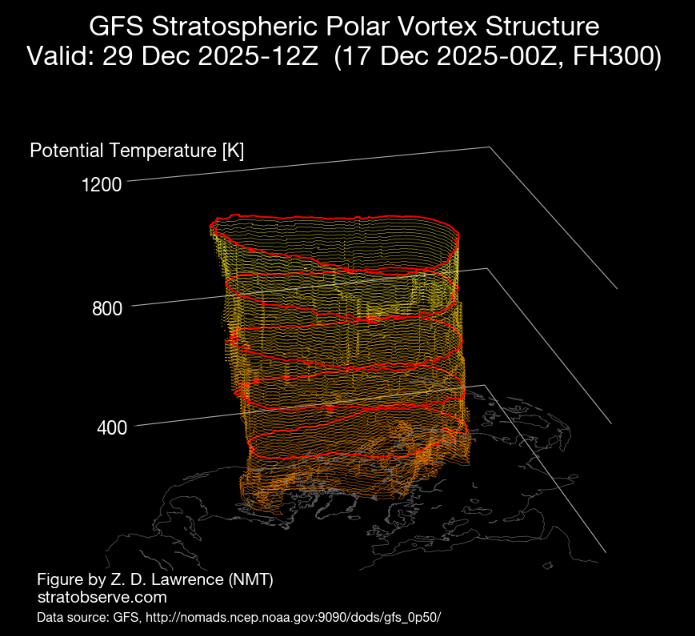
-
I'm not expecting it but on the other hand we're closing in on 30 years so I wouldn't be shocked if this is the time the stars finally align.
-
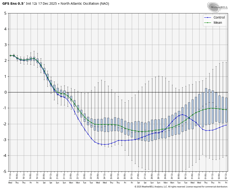
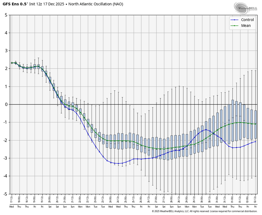
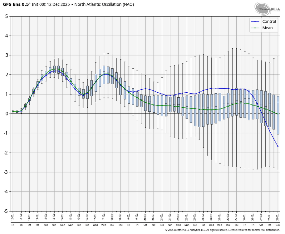
12Z GEFS strong -NAO that starts in just 5 days (12/22) and is the strongest -NAO for days 5-16 averaged out on any GEFS run back to at least Oct 31st: Compare this to the 0Z 12/12/25 run: 12/22-28 were 0 to +0.5 instead of -1 to -2
-
Early start to winter = early start to mud season. 46F
-
that -NAO has grown rather significant to end to the month... can see a redeveloper around the 28th or so with lower heights being forced over the NE. hopefully we can trend it stronger and farther west

-
December 2025 regional war/obs/disco thread
brooklynwx99 replied to Torch Tiger's topic in New England
that -NAO has grown rather significant to end to the month... can see a redeveloper around the 28th or so with lower heights being forced over the NE. hopefully we can trend it stronger and farther west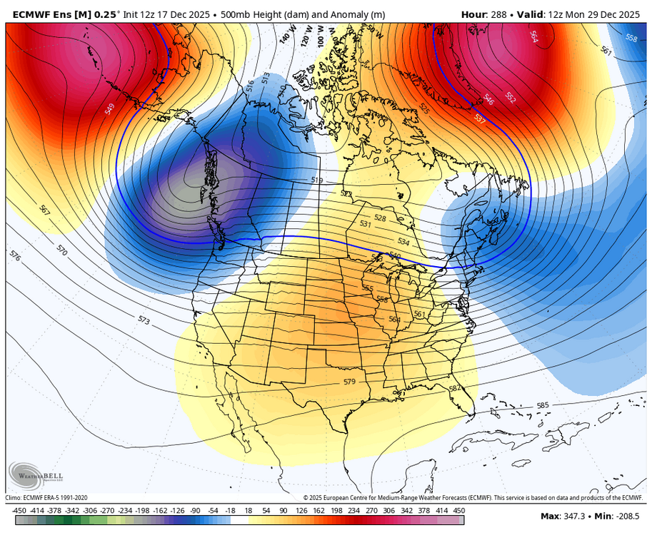
-
It amazes me how you can lock a cutter weeks in advance.
-
ended mid April here last year
-

December 2025 regional war/obs/disco thread
Great Snow 1717 replied to Torch Tiger's topic in New England
Folks look on the bright side!!...only 2 more weeks until one of the most if not the most boring year for weather comes to an end.. -
Tell me it's not winter while you're freezing to death on east winds at Fenway