All Activity
- Past hour
-
I see that everyone is in a Holly Jolly mood a week before Christmas. .
-
It's insane what people can accomplish with paint. I am decent with a pen but sadly you just can't recreate sunlight contrast quite as well as with oil. These are astounding
-
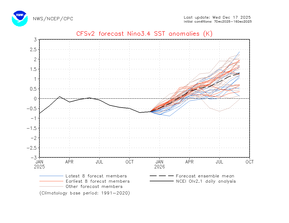
You mentioned that previously, but the Cfs has it getting stronger in its last few forecasts. Here's the latest. When I say strongest, I mean more members are calling for a temp drop.

-
-
Why is this the case?
-
A soaking rain will develop tonight with a storm total 0.50"-1.50" rain likely across the region by the time the storm pulls away late tomorrow. The wind could also gust past 50 mph producing some coastal flooding and beach erosion. It will also be unseasonably mild tomorrow with highs reaching the lower and middle 50s. Behind the storm, the weekend will turn somewhat cooler. No exceptionally cold or warm weather appears likely for the first week of astronomical winter. The probability that December 2025 will have a maximum monthly temperature below 60° has continued to increase. The last time that happened was in 2019 when the monthly high was 58°. If 2025 has a monthly high below 60°, that would be only the fifth such occurrence since 2000 (2003, 2004, 2005, and 2019 are the cases since 2000). The ENSO Region 1+2 anomaly was -0.3°C and the Region 3.4 anomaly was -0.7°C for the week centered around December 10. For the past six weeks, the ENSO Region 1+2 anomaly has averaged -0.33°C and the ENSO Region 3.4 anomaly has averaged -0.67°C. La Niña conditions will likely continue through at least mid-winter. The SOI was -2.23 today. The preliminary Arctic Oscillation (AO) was +2.676 today. Based on sensitivity analysis applied to the latest guidance, there is an implied near 99% probability that New York City will have a cooler than normal December (1991-2020 normal). December will likely finish with a mean temperature near 33.9° (5.2° below normal). Supplemental Information: The projected mean would be 3.5° below the 1981-2010 normal monthly value.
-

December 2025 Short/Medium Range Forecast Thread
Holston_River_Rambler replied to John1122's topic in Tennessee Valley
That definitely looks better, but as far as I can tell, there's nary and Aleutian ridge o' death to be seen I had to go back to early December 1995 to see something similar: -
Too much beer in yours.
-

December 2025 Short/Medium Range Forecast Thread
Daniel Boone replied to John1122's topic in Tennessee Valley
Nina HP was well south then . By Christmas a +PNA with the HP centered over the NW and LP over Aleutians. Trough in East. We should further that Winter in increments in Time and see what evolution was. -

E PA/NJ/DE Winter 2025-26 Obs/Discussion
Birds~69 replied to LVblizzard's topic in Philadelphia Region
Big fan of cool/cold rain and wind. I point and giggle when neighbors stuff gets blown all around, they usually don't like my reaction/response. Drought guy will probably make a appearance as well....happy times. 43F/Overcast -
We actually don’t want to root for a quick fade on the nina, the last several -enso winters that went neutral by Jan basically ended early. Those that maintained nina into Jan gave us wintry periods into Feb (yes despite the canonical Feb torch).
-
December 2025 Short/Medium Range Forecast Thread
Daniel Boone replied to John1122's topic in Tennessee Valley
I used to get mine to post the map now just does Link. Anyway, look what a change by Christmas then. -
Imho, what has thrown a monkey wrench into the mix is the Niña has unexpectedly come back to life. A few weeks ago, it was supposed to have been dead with a solid neutral by now. Instead, those effin' trade winds are back with a vengeance and look to be sticking around into late January. This 850 wind anomaly prog only goes through mid January, but the longer one has it going through most of January, then neutral.
.thumb.png.47a385abfcc5baa44806e81355bc6104.png)
.thumb.png.5347741208521027081a459caf26e9f0.png)
-
Tagged 50 today, the snowpack got completely nuked, the snowstorms are already a distant memory. The next big headline will be just how warm Christmas Day gets. Mid to upper 60’s?
-

Central PA Winter 25/26 Discussion and Obs
Jns2183 replied to MAG5035's topic in Upstate New York/Pennsylvania
It's been 60-70 around Xmas here a few times. That a torch Sent from my SM-S731U using Tapatalk -

December 2025 regional war/obs/disco thread
WinterWolf replied to Torch Tiger's topic in New England
Ahh at this point, it’s(Xmas) far out there…Tuesday is the priority for me. Let’s get that in focus first. But that’s just my opinion. -
December 2025 Short/Medium Range Forecast Thread
Holston_River_Rambler replied to John1122's topic in Tennessee Valley
I got this one from the NCEP reanalysis site for todays date in 1995: -

December 2025 regional war/obs/disco thread
Damage In Tolland replied to Torch Tiger's topic in New England
Too much Shabbs in your head -
December 2025 Short/Medium Range Forecast Thread
Holston_River_Rambler replied to John1122's topic in Tennessee Valley
We desperately need to fill up the thunder in the mountains index. There is hope tonight. -
E PA/NJ/DE Winter 2025-26 Obs/Discussion
Birds~69 replied to LVblizzard's topic in Philadelphia Region
Yep, pretty sure. I don't think I'll make it through the night. Anywho, cool temps, rain and the poor air quality screams relief....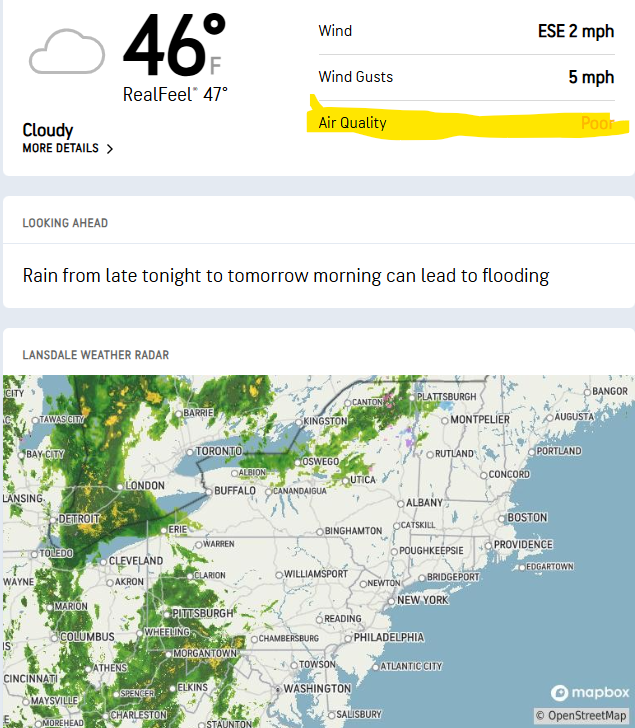
-
December 2025 Short/Medium Range Forecast Thread
Daniel Boone replied to John1122's topic in Tennessee Valley
This is this day in 1995 Plymouth State Weather Center Compare to Christmas then : Plymouth State Weather Center I know it just shows Site link but it goes directly to Map. -
Not stealing any joy, just saying what it shows. Hopefully it’s all further south.
-
December 2025 regional war/obs/disco thread
WinterWolf replied to Torch Tiger's topic in New England
That will happen Monday/Monday night lol. -
December 2025 regional war/obs/disco thread
WinterWolf replied to Torch Tiger's topic in New England
Don’t let them steal your joy…this is the problem with social media. Would anybody not enjoy a 75-80 degree day in mid April…because two or three days later it’s gonna rain and be 41? Of course not. Enjoy the moment…f**k what comes later on. -

December 2025 regional war/obs/disco thread
SouthCoastMA replied to Torch Tiger's topic in New England
I'd like to see the 23rd come in a bit more robust and further south on other guidance like the Euro has had for a few runs, now that we are within 5 days


.png.59a5e44a71916926e20815f87eeea244.png)
.png.b0f3354b8122bfe790b4e59caff0935c.png)


