All Activity
- Past hour
-

E PA/NJ/DE Summer 2025 Obs/Discussion
Hurricane Agnes replied to Hurricane Agnes's topic in Philadelphia Region
And away we go! Currently a hazy, hot, and humid 90 with dp 76 and heat index 102. Lots of big cumulus all around. -

E PA/NJ/DE Summer 2025 Obs/Discussion
mattinpa replied to Hurricane Agnes's topic in Philadelphia Region
I hate the heat coming up, but it has been so cool I can’t complain much. Severe Thunderstorm Watch is up. -
my favorite beach, spent a lot of time there as a kid
-
Glaciator on vis moving quickly into western Ma
-
That storm is now severe warned in western Augusta County. Storm to the SW is here, lots of T&L and rain.
-
Was a standard summer pop up, use a better radar
-
Just issued.
-
I'm guessing the severe warned storms back in W WV are with the actual cold front itself?
-
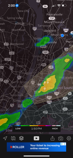
Darkness looking toward Hunts Point and LGA. Looks like it moving more east of instead of NE now. City Island and boats on the Sound might get it good.
-
Severe Thunderstorm Watch up area wide. Severe weather breaking out in western counties. Stay safe!
-
Can see the tops for the storm over the city to my west. Our chance here is with any squall line heading east later.
-
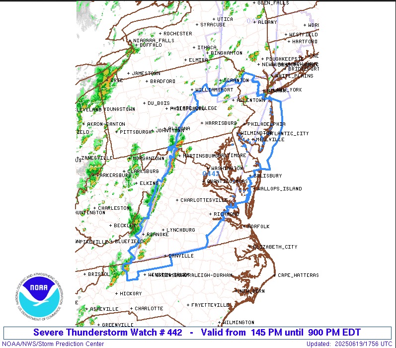
SEVERE THUNDERSTORM WATCH Watch county notification for watch 442 National Weather Service State College PA 148 PM EDT Thu Jun 19 2025 The NWS Storm Prediction Center has issued a * Severe Thunderstorm Watch for portions of District Of Columbia Delaware Maryland Northern North Carolina New Jersey Southeast Pennsylvania Central and Eastern Virginia Eastern Panhandle of West Virginia Coastal Waters * Effective this Thursday afternoon and evening from 145 PM until 900 PM EDT. * Primary threats include... Scattered damaging winds likely with isolated significant gusts to 75 mph possible Isolated large hail events to 1.5 inches in diameter possible SUMMARY...A line of thunderstorms will move off the mountains of western Virginia and southern Pennsylvania, spreading eastward across the watch through the afternoon and evening. Damaging wind gusts and hail are possible in the stronger storms. The severe thunderstorm watch area is approximately along and 90 statute miles east and west of a line from 35 miles north northeast of Allentown PA to 20 miles east of Danville VA. For a complete depiction of the watch see the associated watch outline update (WOUS64 KWNS WOU2). .
-
Man it....is....gross....out
-
Looks like another one behind it. Storms is cool but I wish they held off till later. A lot of people relying on a dry early to mid afternoon today.
-
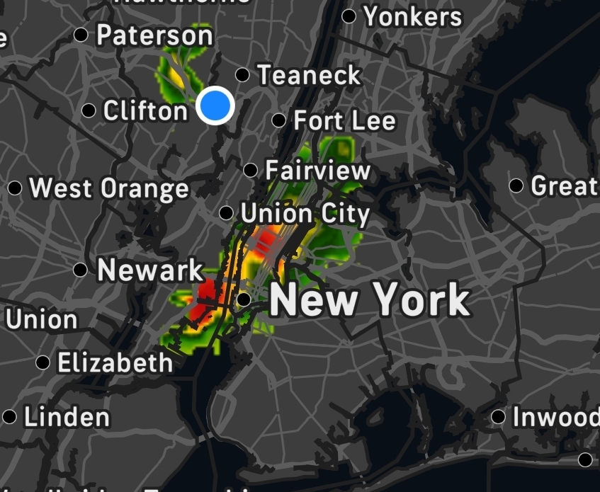
Nyc storm. It's since expanded nicely
.thumb.jpg.050ba4a77701add0a9e78b471d9fff22.jpg)
-
Correct 10% probs on two or more tornadoes... 20/10 on hail probs
- 1,097 replies
-
- 1
-

-
- severe
- thunderstorms
- (and 2 more)
-
-
New STW up for my yard Severe Thunderstorm Warning MDC021-043-WVC003-037-065-191845- /O.NEW.KLWX.SV.W.0147.250619T1744Z-250619T1845Z/ BULLETIN - IMMEDIATE BROADCAST REQUESTED Severe Thunderstorm Warning National Weather Service Baltimore MD/Washington DC 144 PM EDT Thu Jun 19 2025 The National Weather Service in Sterling Virginia has issued a * Severe Thunderstorm Warning for... Washington County in north central Maryland... Northwestern Frederick County in north central Maryland... Northeastern Jefferson County in the Panhandle of West Virginia... Central Morgan County in the Panhandle of West Virginia... Berkeley County in the Panhandle of West Virginia... * Until 245 PM EDT. * At 144 PM EDT, a severe thunderstorm was located 7 miles northeast of Greenwood, moving east at 50 mph. HAZARD...60 mph wind gusts. SOURCE...Radar indicated. IMPACT...Damaging winds will cause some trees and large branches to fall. This could injure those outdoors, as well as damage homes and vehicles. Roadways may become blocked by downed trees. Localized power outages are possible. Unsecured light objects may become projectiles. * Locations impacted include... Hagerstown, Martinsburg, Thurmont, Shepherdstown, Hancock, Municipal Stadium, Greenwood, Robinwood, Fountainhead-Orchard Hills, Boonsboro, Smithsburg, Paramount-Long Meadow, Wilson-Conococheague, Williamsport, Berkeley Springs, Mount Aetna, Mount Lena, San Mar, Long Meadow, and Wolfsville. PRECAUTIONARY/PREPAREDNESS ACTIONS... For your protection move to an interior room on the lowest floor of a building. Large hail, damaging wind, and continuous cloud to ground lightning are occurring with this storm. Move indoors immediately. Lightning is one of nature`s leading killers. Remember, if you can hear thunder, you are close enough to be struck by lightning. Torrential rainfall is occurring with this storm, and may lead to flash flooding. Do not drive your vehicle through flooded roadways.
-
URGENT - IMMEDIATE BROADCAST REQUESTED Severe Thunderstorm Watch Number 442 NWS Storm Prediction Center Norman OK 145 PM EDT Thu Jun 19 2025 The NWS Storm Prediction Center has issued a * Severe Thunderstorm Watch for portions of District Of Columbia Delaware Maryland Northern North Carolina New Jersey Southeast Pennsylvania Central and Eastern Virginia Eastern Panhandle of West Virginia Coastal Waters * Effective this Thursday afternoon and evening from 145 PM until 900 PM EDT. * Primary threats include... Scattered damaging winds likely with isolated significant gusts to 75 mph possible Isolated large hail events to 1.5 inches in diameter possible SUMMARY...A line of thunderstorms will move off the mountains of western Virginia and southern Pennsylvania, spreading eastward across the watch through the afternoon and evening. Damaging wind gusts and hail are possible in the stronger storms. The severe thunderstorm watch area is approximately along and 90 statute miles east and west of a line from 35 miles north northeast of Allentown PA to 20 miles east of Danville VA. For a complete depiction of the watch see the associated watch outline update (WOUS64 KWNS WOU2).
-
I'm guessing 70/30 wind probs based on the watch wording?
-
You should be very pleased with my Michigan round-up then! You are the one who has thrown out comparisons to White Lake, Flint, Saginaw, and Ann Arbor in the past - all of which were warmer than DTW in my summary, some by several degrees.
-
Mentions isolated significant gusts to 75mph
-
Why is it weak?
-
Watch up until 9pm
- 1,097 replies
-
- 1
-
-
- severe
- thunderstorms
- (and 2 more)
-


.jpg.03e1f90d0a4f5479626099263f610b43.jpg)


