All Activity
- Past hour
-
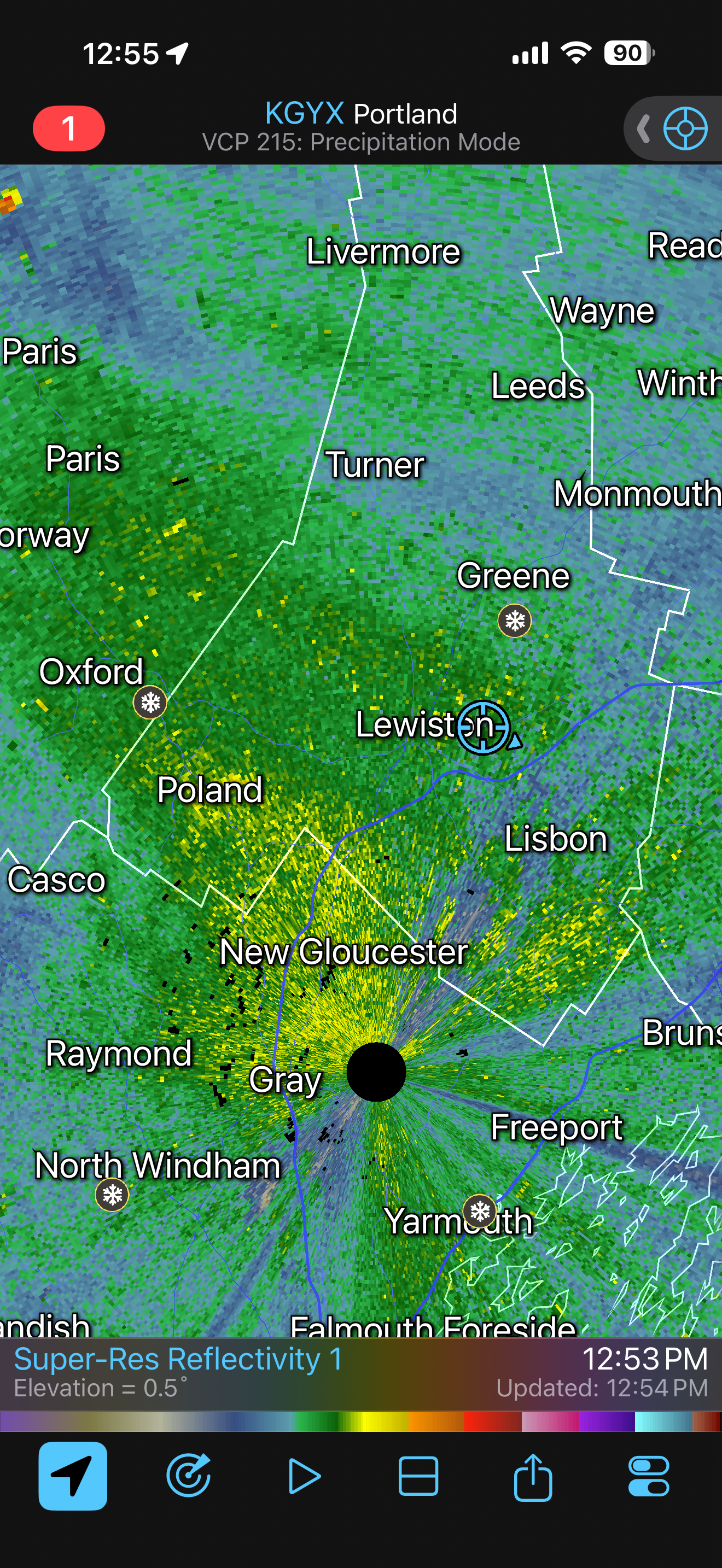
We’ve gone to sleety snow with some freezing mist. Small bouncing IP mixed with some flakes.
-
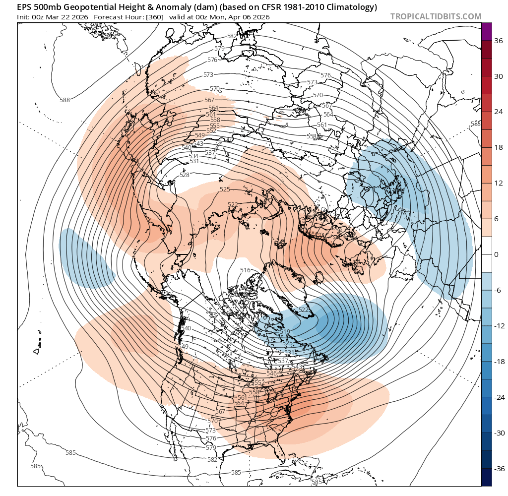
I actually looked at that and figured here we go-spring! Then I realized it’s d15. Back to thinking about other things…
-
if any ridging is weak and east towards Scandinavia, meh...summer rolls on

-

Occasional Thoughts on Climate Change
donsutherland1 replied to donsutherland1's topic in Climate Change
Yes. that's correct regarding San Diego and Los Angeles. That's why I referred to it as a "localized heat event in southern California." Some heat came eastward into a portion of Arizona (Yuma's 100° reading), but this wasn't the kind of widespread heatwave like the ongoing on. It was nowhere near as intense as the ongoing one. Unfortunately, the maps have a a nine-hour gap between observations and there isn't a larger set of observations. I suspect that the offshore winds winds seen north of Los Angeles at the 4:35 am PDT observation sank south after that observation. The wind then turned onshore shortly before the 1:35 pm PDT observation, as the temperature was still 97° in the Los Angeles area.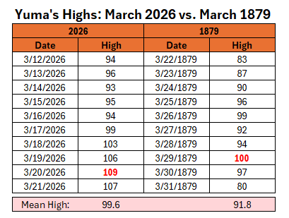
-
Coming down at some of the heaviest rates thus far, +SN, 30F

-
Stop it / that would be horrible
-
I just switched back to ice pellets/graupel. You and Dryslot should do well.
-
Found a snowcrete pile at the odenton marc station this morning
-
Between 3 and 4", still moderate but barely. Radar points to this continuing the rest of the day, though accumulation might be minimal later this aft. Maybe reach 6"?
-
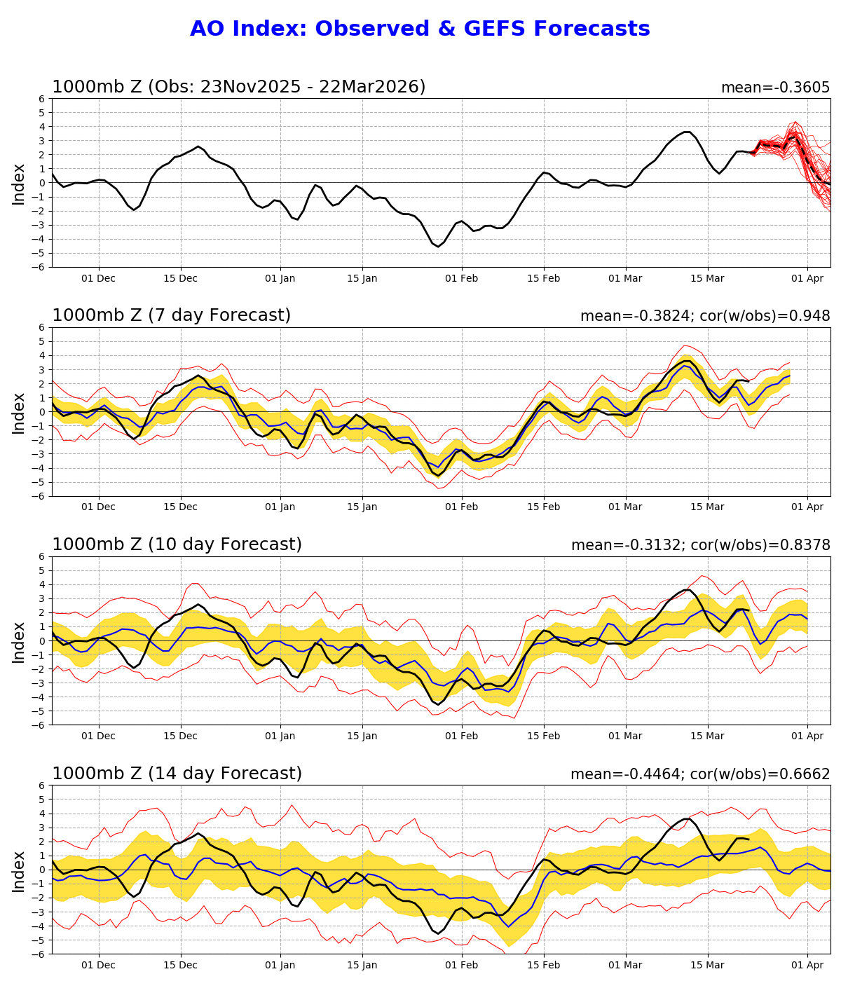
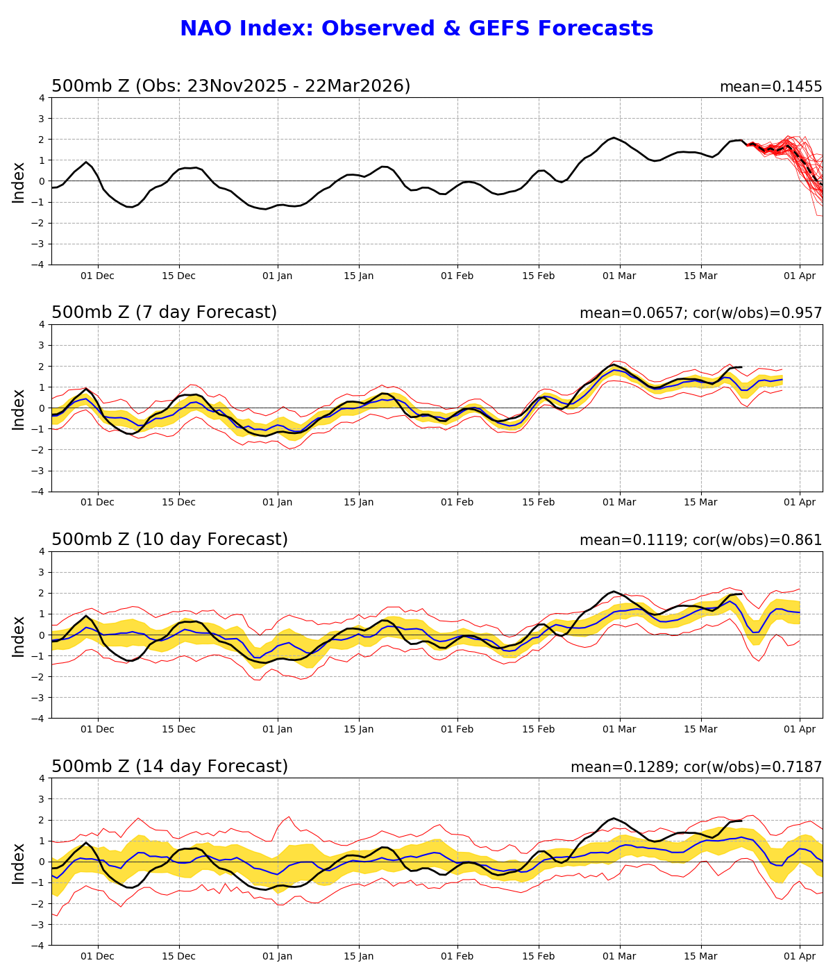
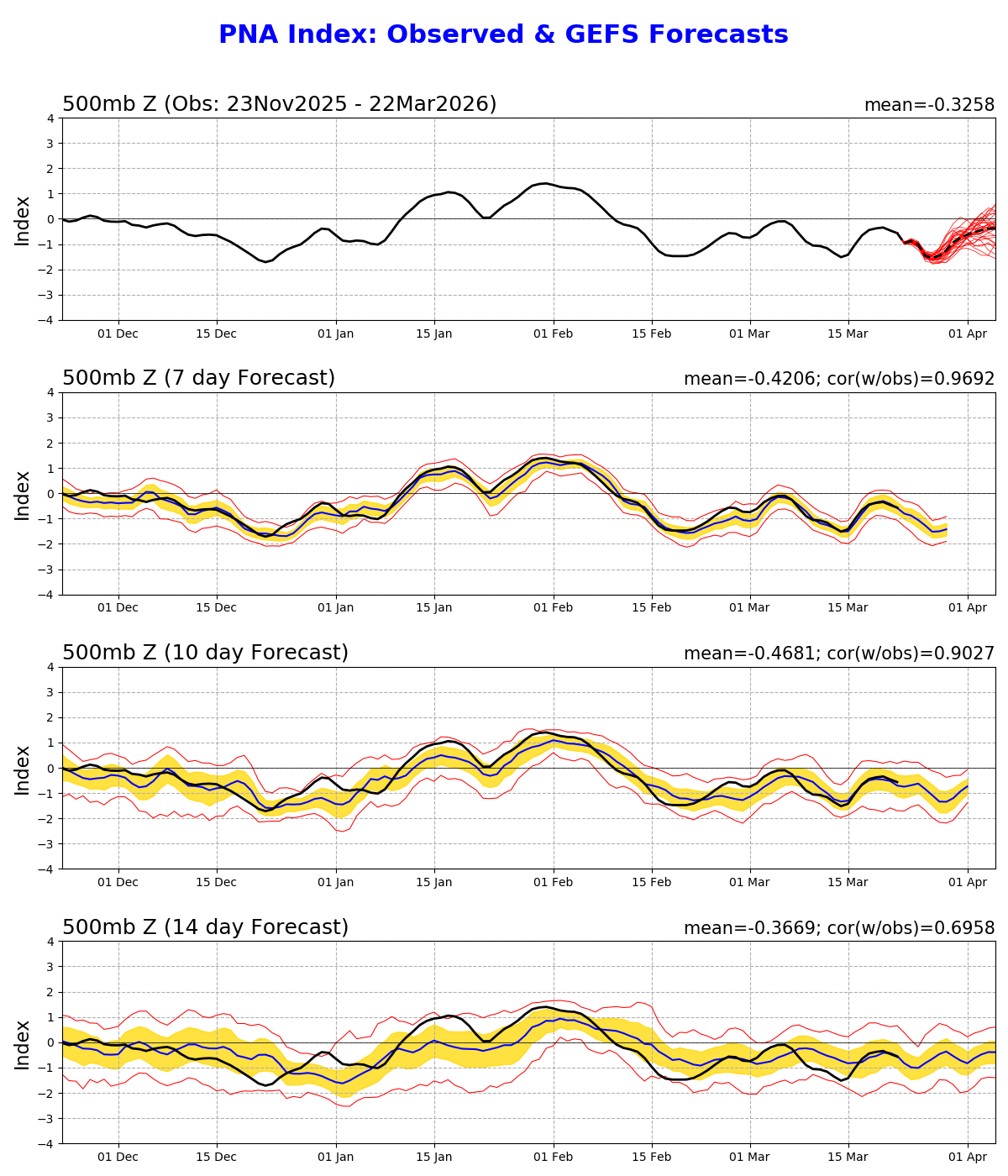
Positive to neutral…and if you look at the 10-14 day forecasts it’s been verifying more positive.
-
It’s pleasant outside, if not a little brisk; sweatpants with a Henley while sitting in partly sunny skies while the kids jump on the trampoline… temp is 55.
-
0.6” snow 31.6° with -ZR and an occasional frozen hydrometeor.
-
Its on orange street in Lew.
-
Has the Sabattus / Orange water main break washed any of it away?!
-
Yep, onshore flow and low cloud gunk.
-
Thanks, Don. Fantastic post! I’ll just add that, as I assume you realize, that LA and SD did actually both hit 99 on 3/29/1879 and that those remain their hottest on record in all of March. The 100 of 3/29/1879 remained at least tied for the hottest in all of March in Yuma til it hit 102 in 2004. And the current heatwave obliterated these as you know with 109 for the hottest (3/20/2026). So, I agree that the tweeter is taking what was largely a localized historic heat event for S CA and making it seem as if it were in a much larger region and more historic in the SW US overall than the current one. Aside: Meteorology related Q: I wonder why this official map shows onshore (SE) winds in LA and a temp. of 97 at 1:35PM PST on 3/29/1879? The 97 is consistent with the 99 high, but the SE winds aren’t. Anyone know? My guess is that the winds had been offshore til just before 1:35PM and that the 99 high occurred a little before 1:35PM. If so, the temps were just starting to fall with the SE winds. Note that SD, also shown with SE winds then, had already fallen way down to 79 then. Thus, I’m guessing their winds shifted sooner: https://library.oarcloud.noaa.gov/docs.lib/htdocs/rescue/dwm/1879/18790329.pdf
-

Central PA Spring 2026 Discussion/Obs Thread
TheDreamTraveler replied to Voyager's topic in Upstate New York/Pennsylvania
Getting 3 severe weather threats in less than 2 weeks in the middle of March is kinda wild not gonna lie. I'm glad it's raining a lot more now not just because of the drought but because I really enjoy heavy rains. All the drought was really depressing lol -
That's crazy
-
36 in northeast Illinois and 88 in southwest Illinois. Wild gradient
-
Had a brief snow shower that covered the ground, now just a cold rain.
-
Forget it if this is right


-
Just in time for April

-
*shudder* That was the year after I opened a ski/snowboard shop. Both of my first two years sucked for snow.
-
Timber just in time for April


-
Snark with nothing useful, thanks