All Activity
- Past hour
-
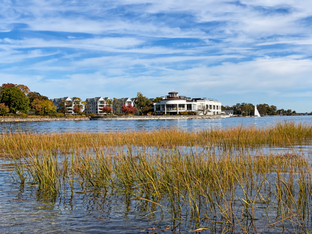
Cirrus and cirrostratus clouds this morning.
-
Wendy was here (frosty) low of 36
-
 https://zpacksupply.shop/# generic zithromax over the counter
-

Yellow Medicine County, MN - Climate Fact or Climate Fiction?
Cobalt replied to Cobalt's topic in Climate Change
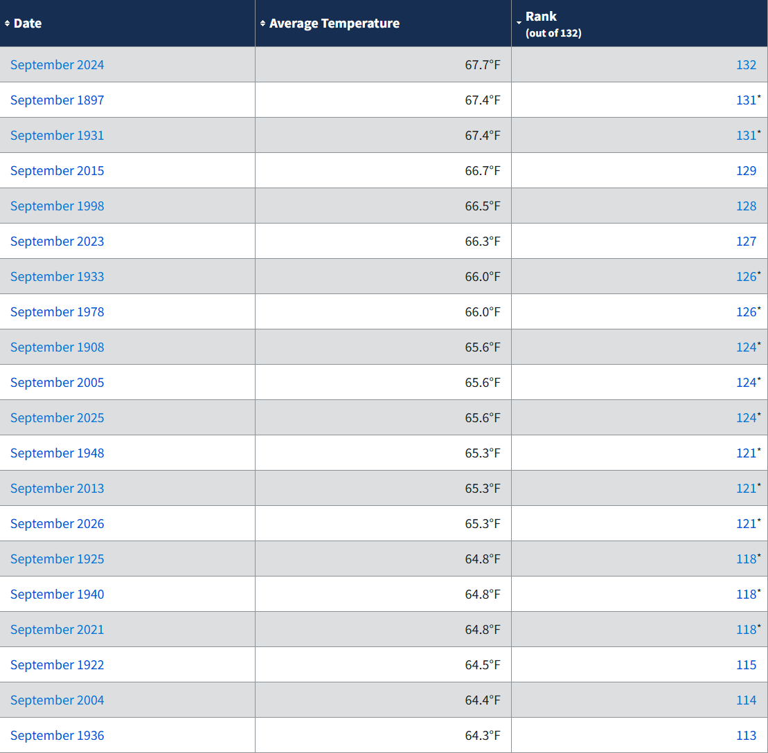
10 of the 20 warmest Septembers in Yellow Medicine County, MN (Population 9,477) have occurred within the past 30 years. This means that the other 10 occurred over the 100 years prior.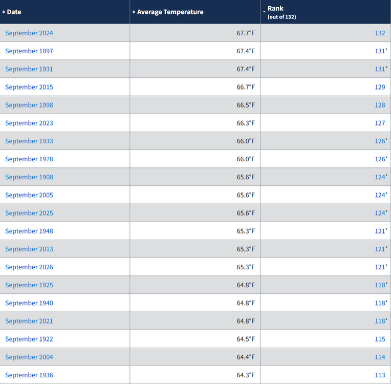
-
It’s the only weather we’ve got
-

2026-2027 Record-breaking El Nino
SnoSki14 replied to Stormchaserchuck1's topic in Weather Forecasting and Discussion
You're actually right this time. Upper 70s in my forecast right now. Could be 80+ for 2-3 days. Crazy stuff -
It’s like rai-e-aaaain, on your Christmas day
-
27.1 at 1100 ft this morning. We microclimate in a big way
-

2026-2027 Record-breaking El Nino
qg_omega replied to Stormchaserchuck1's topic in Weather Forecasting and Discussion
Record warmth possible to start November -

Winter 2026-2027 Speculation
Prismshine Productions replied to 40/70 Benchmark's topic in New England
The replacement to the CFSv2 Sent from my SM-S176V using Tapatalk -
We need it to look like music video outside by early-mid January. There are no extra seats on this ride cause Alanis took all of them. Isn't that ironic?
-
https://zpacksupply.shop/# buy zithromax 1000 mg online
- Today
-
Very good. There you go calling it fake cold after complaining yesterday that people poke fun at you. Don’t hate on areas that produce their own cold while others need Canada to come to the rescue for their cold. It’s all weather.
-
Love checking in on this thread every October to the same 20 pages of arguing about fake cold and what kind of foliage season it's been.
-
Snow tracking time will be coming soon!
-
Nothing! LOL 0c line closing in Blizz!
-
I don’t like getting into climate change discussions because people want to make it political. But being a mechanical engineer and scientist I know two things….climate change is real and we (humans) have added to that the change. How much we have impacted CC vs the earths normal cyclical waves, I can’t tell you. .
-

Yellow Medicine County, MN - Climate Fact or Climate Fiction?
ChescoWx replied to Cobalt's topic in Climate Change
Still using altered not actual data with those figures....the facts are 6 of the top 10 warmest Septembers all occurred prior to 2000.With 3 of the top 6 warmest all before 1935! -
EWR the last 10 days at a +1.8 Date High Low Departure 14 80 64 +14 15 66 54 +2 16 75 60 +11 17 61 43 -5 18 60 38 -8 19 66 41 -2 20 70 45 +2 21 65 48 +1 22 69 48 +4 23 62 46 -1 New Brunswick, NJ (+1.4) Date High Low Departure 10/14 81 50 +10 10/15 68 54 +6 10/16 76 50 +8 10/17 55 33 -10 10/18 62 35 -5 10/19 68 42 +1 10/20 71 45 +5 10/21 68 38 0 10/22 71 43 +4 10/23 63 32 -7 NYC (+1.1) Central Park — October 14–23, 2026 Date High Low Departure 14 77 64 +13 15 64 54 +1 16 72 59 +8 17 62 43 -5 18 57 41 -8 19 62 47 -2 20 67 50 +3 21 62 50 0 22 67 49 +2 23 59 47 -2
-
Records: Highs: EWR: 83 (2001) NYC: 79 (2001) LGA: 80 (2001) JFK: 74 (2017) Lows: EWR: 28 (1969) NYC: 31 (1969) LGA: 30 (1969) JFK: 32 (1969) Historical: 1785 - A four day rain swelled the Merrimack River in New Hampshire and Massachusetts to the greatest height of record causing extensive damage to bridges and mills. (David Ludlum) 1878 - A hurricane produced widespread damage across North Carolina, Virginia, Maryland, New Jersey and Pennsylvania. At Philadelphia PA, the hurricane was the worst of record. (David Ludlum) 1878: The Gale of 1878 was an intense Category 2 hurricane that was active between October 18 and October 25. It caused extensive damage from Cuba to New England. Believed to be the strongest storm to hit the Washington - Baltimore region since hurricane records began in 1851. 1937 - A snow squall in Buffalo NY tied up traffic in six inches of slush. (David Ludlum) 1947 - The Bar Harbor holocaust occurred in Maine when forest fires consumed homes and a medical research institute. The fires claimed 17 lives, and caused thirty million dollars damage. (David Ludlum) 1951 - Sacramento, CA, reported a barometric pressure of 29.42 inches, to establish a record for October. (The Weather Channel) 1969 - Unseasonably cold air gripped the northeastern U.S. Lows of 10 degrees at Concord, NH, and 6 degrees at Albany NY established October records. (The Weather Channel) 1987 - Snow fell across northeast Minnesota and northwest Wisconsin overnight, with five inches reported at Poplar Lake MN and Gunflint Trail MN. Thunderstorm rains caused flash flooding in south central Arizona, with street flooding reported around Las Vegas NV. Strong northwesterly winds gusting to 50 mph downed some trees and power lines in western Pennsylvania and the northern panhandle of West Virginia. (The National Weather Summary) (Storm Data) 1988 - Strong winds circulating around a deep low pressure centered produced snow squalls in the Great Lakes Region, with six inches reported at Ironwood MI. Wind gusts to 80 mph were reported at State College PA. (The National Weather Summary) (Storm Data) 1989 - A storm in the western U.S. produced up to three feet of snow in the mountains around Lake Tahoe, with 21 inches reported at Donner Summit. Thunderstorms in northern California produced 3.36 inches of rain at Redding to establish a 24 hour record for October, and bring their rainfall total for the month to a record 5.11 inches. Chiefly "Indian Summer" type weather prevailed across the rest of the nation. Fifteen cities in the north central U.S. reported record high temperatures for the date as readings soared into the 70s and 80s. Record highs included 74 degrees at International Falls MN, and 86 degrees at Yankton SD. (The National Weather Summary) (Storm Data) 2005 - Hurricane Wilma reached the U.S. coastline near Everglades City in Florida with maximum sustained winds near 120 mph. The hurricane accelerated across south Florida and the Miami/Fort Lauderdale area, exiting the coast later the same day. There were 10 fatalities in Florida, and nearly 6 million people lost power, the most widespread power outage in Florida history. Preliminary estimates of insured losses in Florida were over $6 billion, while uninsured losses were over $12 billion.
-

October 2026 General Discussion
OrdIowPitMsp replied to SchaumburgStormer's topic in Lakes/Ohio Valley
If this doesn’t end up the warmest October on record here it will certainly be top 5. -
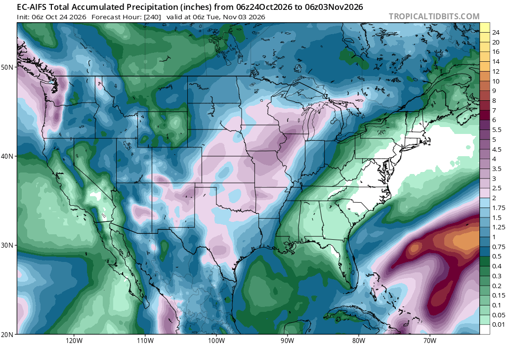
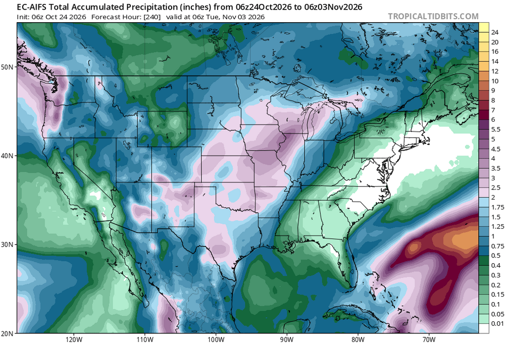
51 / 36 and another onshore but dry day. Hit 30.5 here this morning. Overall at or above normal the next week with a few days pushing into the 70s in the warm spots Mon / Thu - Sat and continued dry. Next shot at meaningful rain if something else doesnt materialize this week, would be towars 11/1-11/4 period as trough digs and moves into the MW.
-
They are easily defaulting to ENSO-climo like everyone is doing. We have yet to see a more than 4-day +PNA period since the El Nino developed in April.
-
I had to this past summer when there was a software issue . It’s always been dead nuts accurate . In icing events for example with zr involved. It’s simply an extreme example of a microclimate. Almost same elevation as ORH and typically very similar temperatures especially on fake radiating nights. I mean there has not been any frost this fall. Not on cars or rooftops
-
ORH was 34° so I don’t think his station is too far off