All Activity
- Past hour
-

Central PA Spring 2026 Discussion/Obs Thread
mahantango#1 replied to Voyager's topic in Upstate New York/Pennsylvania
80 here with a dp of 71. -

Central PA Spring 2026 Discussion/Obs Thread
WmsptWx replied to Voyager's topic in Upstate New York/Pennsylvania
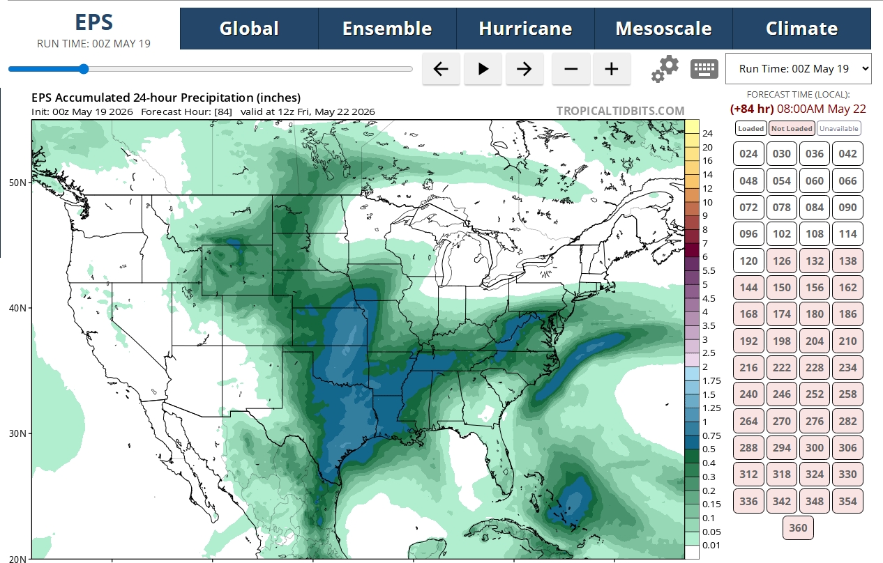
I can honestly live with this, as long as it's not the entire goddamned summer. Thursday Mostly sunny, with a high near 65. East wind around 8 mph. Thursday Night Mostly cloudy, with a low around 45. Friday Showers likely, mainly after 2pm. Mostly cloudy, with a high near 60. Chance of precipitation is 70%. Friday Night Showers. Low around 45. Chance of precipitation is 90%. Saturday Showers. High near 61. Chance of precipitation is 90%. Saturday Night Showers. Low around 52. Chance of precipitation is 80%. Sunday Showers likely and possibly a thunderstorm. Mostly cloudy, with a high near 71. Chance of precipitation is 60%. Sunday Night A chance of showers and thunderstorms. Mostly cloudy, with a low around 54. Chance of precipitation is 40%. Memorial Day A chance of showers and thunderstorms. Mostly cloudy, with a high near 74. Chance of precipitation is 30%. -
You can see how quickly it shot up once that wind went from calm to like 10+ sustained.
-
Central PA Spring 2026 Discussion/Obs Thread
WmsptWx replied to Voyager's topic in Upstate New York/Pennsylvania
I did notice this morning that the local TV met in Altoona disagrees with the weather apps for the weekend, as the lowest she had Saturday going was 60-61. My Google App currently shows 49. -
heh... we did not... I was 61 until twilight glow ... 81 now
-
0.79" of rain from shwrs/stms last night. 0.98" for a 2 day total. That helps, but still sucking hind teet for May as we have only a 1/3 of the 3.30" avg. 6+" in April was great for catching up from the drier previous months. Update: Fire 100% contained. Looks like a power line started the fire. Section of Hwy 61 that was closed will be opened again later today approx 8 pm.
-

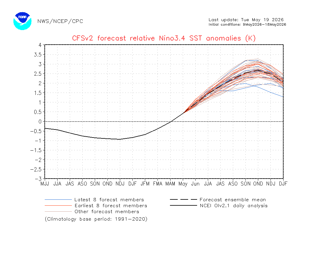
2026-2027 Strong/Super El Nino
GaWx replied to Stormchaserchuck1's topic in Weather Forecasting and Discussion
Evidently based on pro mets I follow, having relatively cooler SST anomalies near Australia compared to warmer anomalies to the east of there will be crucial. For 2023, the models, which earlier had the nice E US trough/Aleutian low that we were salivating over, were then were erroneously forecasting cooler near Australia, which is pretty typical of El Niño. -
Friday and Saturday seem tough. Maybe Sunday and/or Monday? Curious how the fields take the water after how dry it’s been. If were rained out I’m going to hopefully go see the Mandalorian movie lol
-
We need the robots to pull through for a best case scenario this weekend.
-
No storms and a rainy 3 day weekend in the 40’s . Sounds perfect for our regions run of luck last 5-6 years
-

2026-2027 Strong/Super El Nino
40/70 Benchmark replied to Stormchaserchuck1's topic in Weather Forecasting and Discussion
Either way it will be mild, but we would at least have a shot at a decent stretch if you're right. So the +IOD wasn't that strong in 2015 and 2023?? -
Mine and the 3 others on my road all were between 94-95.
-
Looks legit to me. They mixed out. There were random periods of overnight mixing across the region…like at MPV.
-
2026-2027 Strong/Super El Nino
40/70 Benchmark replied to Stormchaserchuck1's topic in Weather Forecasting and Discussion
The coming winter season is goin to be a good test as to whether the absolute RONI value or the delta between it and the RONI is of greater significance. The key is whether or not we get that "La Nino" half-assed Aleutian low like 2023 again. -
I’ll take the under city east. .1”-.25” strong onshore flow will do it thing. .
-
Almost 80 here at 8:44 am
-
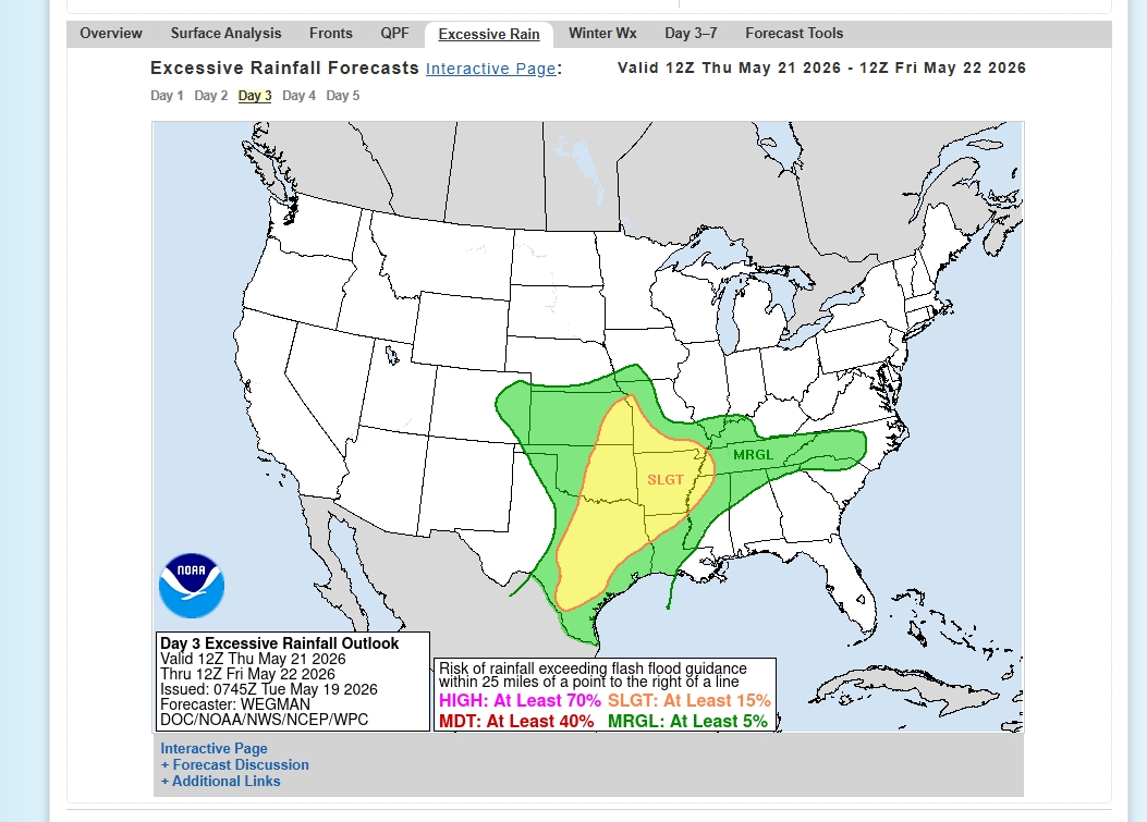
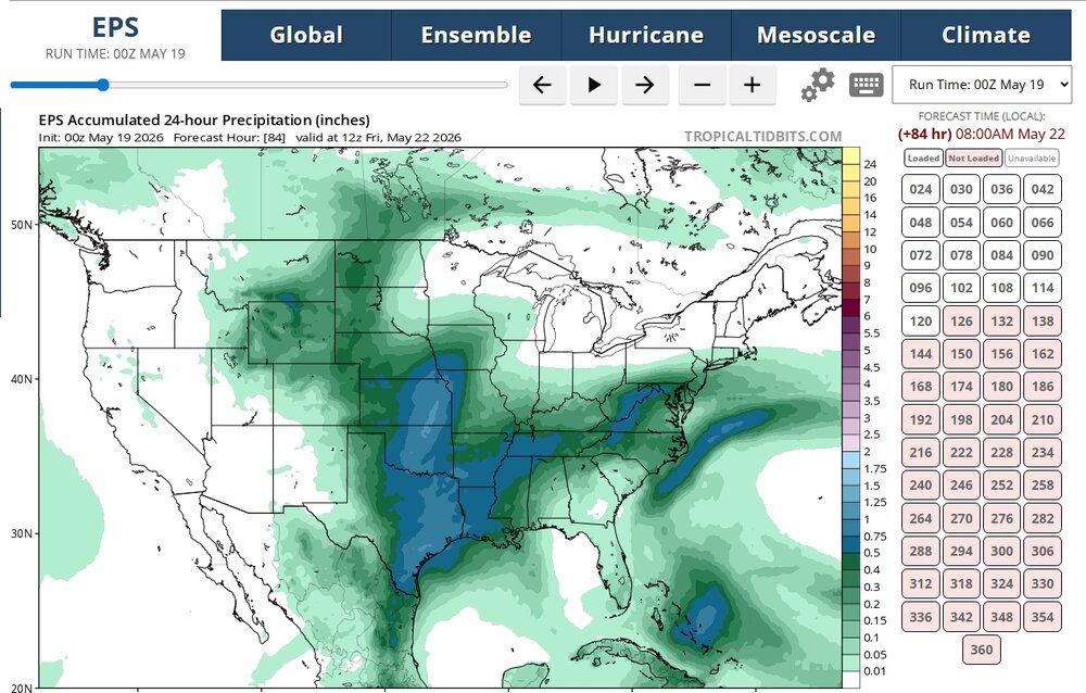
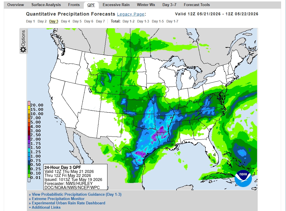
FYI… looks like we might get active this week. .
-
Where was it headed, maybe if you let it get on the bus it would have taken it away from your neighborhood?
-
2026-2027 Strong/Super El Nino
GaWx replied to Stormchaserchuck1's topic in Weather Forecasting and Discussion
Latest CFS RONI peaks at +2.65 to +2.70 in OND, which would be a record high beating 1982: Latest CFS ONI is +3.25-30 in OND, meaning keeping the differential near 0.6: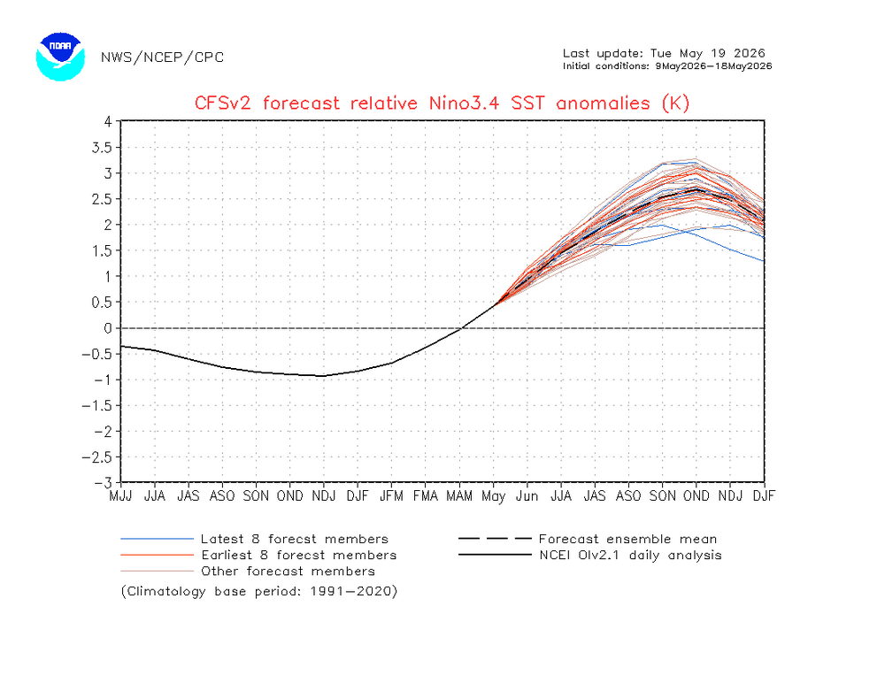

-
Is your sounding from WeatherFront? I’ve been getting monthly subs to different apps seeing what one I like. WeatherFront is what I have now and I like it. .
-
any severe weather expected tomorrow with that cold front?
-
-
-
-
Records: Highs: EWR: 98 (1962) NYC: 99 (1962) LGA: 96 (2017) JFK: 92 (2017) Lows; EWR: 39 (2002) NYC: 38 (1976) LGA: 43 (1976) JFK: 42 (2002) Historical: 1780 - The infamous "dark day" in New England tradition. At noon it was nearly as dark as night. Chickens went to roost, and many persons were fearful of divine wrath. The phenomena was caused by forest fires to the west of New England. (David Ludlum) 1915: A spring storm came to an end after producing widespread snow. Total snowfall from the storm included: 17.6 inches in Scottsbluff, NE, 8 inches at Cheyenne, WY and 7 inches at Chadron, NE. 1955 - Lake Maloya NM received 11.28 inches of rain in 24 hours to establish a state record. (The Weather Channel) 1962: A heat wave gripped the East Coast with high temperatures reaching 99° at New York City, 98° at Baltimore, MD and 96° at Philadelphia, PA (all either broke or tied records for the month of May.). Other daily records included: Greenville-Spartanburg, SC: 99°, Newark, NJ: 98°, Concord, NH: 97°, Allentown, PA: 97°, Richmond, VA: 97°, Athens, GA: 97°, Columbus, GA: 97°, Philadelphia, PA: 96°, Atlantic City, NJ: 96°, Roanoke, VA: 96°, LaGuardia, NY: 95°, Harrisburg, PA: 95°, Wilmington, DE: 95°, Charlotte, NC: 95°, Raleigh, NC: 95°, Nashville, TN: 95°, Hartford, CT: 94°, Lynchburg, VA: 93 °F. 1975 - Thunderstorms produced golf ball size hail and wind gusts to 110 mph in Minnesota, between Fridley and Hugo. Fifty persons were injured. The hail and high winds destroyed fifty mobile homes, and a dozen aircraft, and also destroyed a third of the Brighton Elementary School. (The Weather Channel) 1977: Over a 9 day period, this was the fourth day of a terrible heat in the Chicago, IL area. Over the 9 day period, the daily high temperature was 90° or higher setting eight high temperature records. The monthly average for those 9 days was 69.3° or about 20 degrees above normal. 1987 - Thunderstorms in Texas produced thirteen inches of rain northwest of Lavernia. The heavy rain, along with golf ball size hail, destroyed eighty percent of the crops in the area, while high winds toppled trees. Golf ball size hail was also reported south of Dallas and around San Antonio. Up to eight inches of rain drenched Guadelupe County. (The National Weather Summary) (Storm Data) 1988 - Severe thunderstorms in southwest Texas produced hail as large as tennis balls around Midland, with the hail accumulating up to a foot deep. Showers and thunderstorms in the Middle Atlantic Coast Region produced 3.5 inches of rain near Schuylkill PA. (The National Weather Summary) (Storm Data) 1989 - Thunderstorms developing ahead of a cold front spawned ten tornadoes from Illinois to Tennessee during the afternoon and night. Snow, wind and cold prevailed in the Northern Plateau Region and the Northern Rockies. Dixie, ID, was blanketed with nine inches of snow, winds gusted to 87 mph at Choteau MT, and the temperature at Crater Lake, OR, dipped to 11 degrees. (Storm Data) (The National Weather Summary) 1990 - Thunderstorms deluged Hot Springs AR with thirteen inches of rain in nine hours resulting in a devastating flood. Two waves of water, four to six feet deep, swept down Central Avenue flooding stores and the famous bathhouses on Bathhouse Row. Water released from Lake Hamilton devastated the area between it and Remmel Dam. The 500 foot Carpenter Dam Bridge across Lake Catherine was completely washed away, as were cabins and mobile homes near the lake, many of which flowed right over the top of Remmel Dam. (The National Weather Summary) (Storm Data) 1997: Record maximum temperature for Washington, DC for the date is 96 °F. (Ref. Washington Weather Records - KDCA) 2002: Key West, FL recorded 4.02 inches of rain in 24 hours as a slow moving band of storms lingered over the area. Their average May precipitation is 3.31 inches. Snowflakes flew across Lower Michigan as record cold weather prevails. Record lows include the 26° at Lansing, 29° at Muskegon and 30° at Grand Rapids. The freezing temperatures cause heavy losses to orchards across western Lower Michigan. Meanwhile on the same day Fairbanks, AK reached 77°. (Ref. Wilson Wx. History) 2008Southwest:Even by American desert standards, the searing heat is one for the books. Death Valley, California sizzles at 120 °F while residents of Phoenix, Arizona witness the year's first high of 110 °F. (Ref. WxDoctor) 2009Minnesota: At 4 PM ,Granite Falls in southwestern Minnesota bakes with a temperature of 100 °F while residents of Grand Marais on the Lake Superior shore shiver with a 34 °F (a difference of 66 °F). (Ref. WxDoctor) 2018: May 19th had 0.50 inches of rain a 9-year daily record for the date; the previous record was only 0.09 in 2015. Glen Allen would get 9.20 inches of rain by the time this Weather system had finished on the 19th. This was from moisture come up the coast from Florida with a stationery just north of central Virginia. Also more than 10 inches of rain fell in SW Henrico County during a 4 day period of May 16 to May 19th. (Ref. Richmond Times Dispatch)