All Activity
- Past hour
-
Best time of the year. Last few weeks of August and the first few weeks of September. Bluebird skies today.

-
 No surprise, Euro didn't bite & only the AI EURO did for a run.
 -
I’m not saying it CAN’T happen, I’m going with my gut and what has transpired thus far/what is projected to transpire in early-mid September. It is my strong OPINION that this is not going to be an above normal ACE season. Can I be wrong? Sure
-
1. 2024 (161 ACE) didn’t get 2nd major til late Sep. 2. 2023 (146) didn’t have 1st MH til 8/20. 3. 2021 (146) 1st MH 8/20. 4. 2020 (180) 8/26 5. 2019 (132) 8/30 6. 2018 (133) 9/10 7. 2017 (225) 8/25 8. 2016 (141) 8/30 ——— 2025 got 1st MH on 8/16. Seasons with 1st MH by 8/16: 2024, 2008, 2005, 2004, 2000, 1996, 1995…only 7 of last 30 (23%).
-

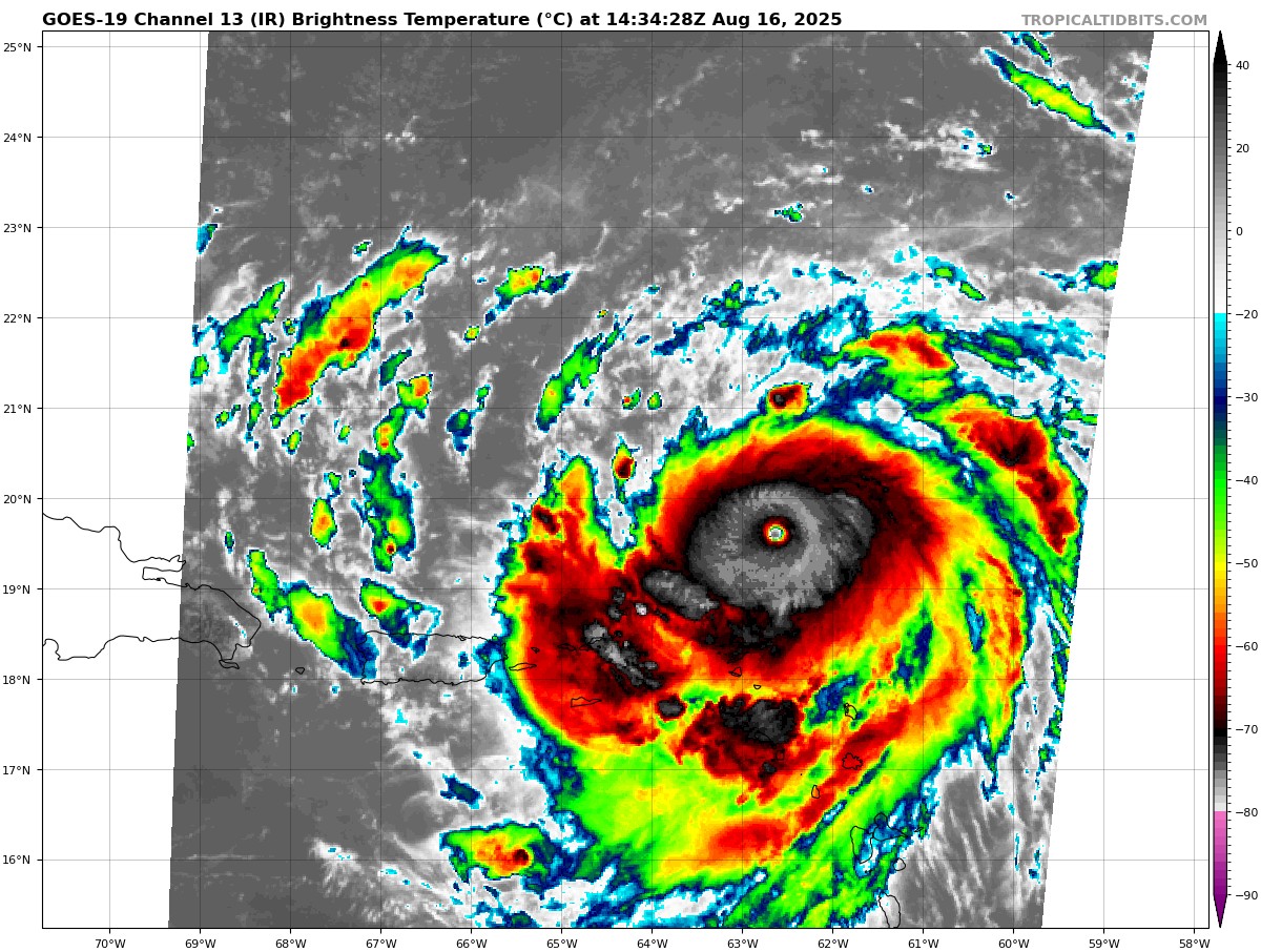
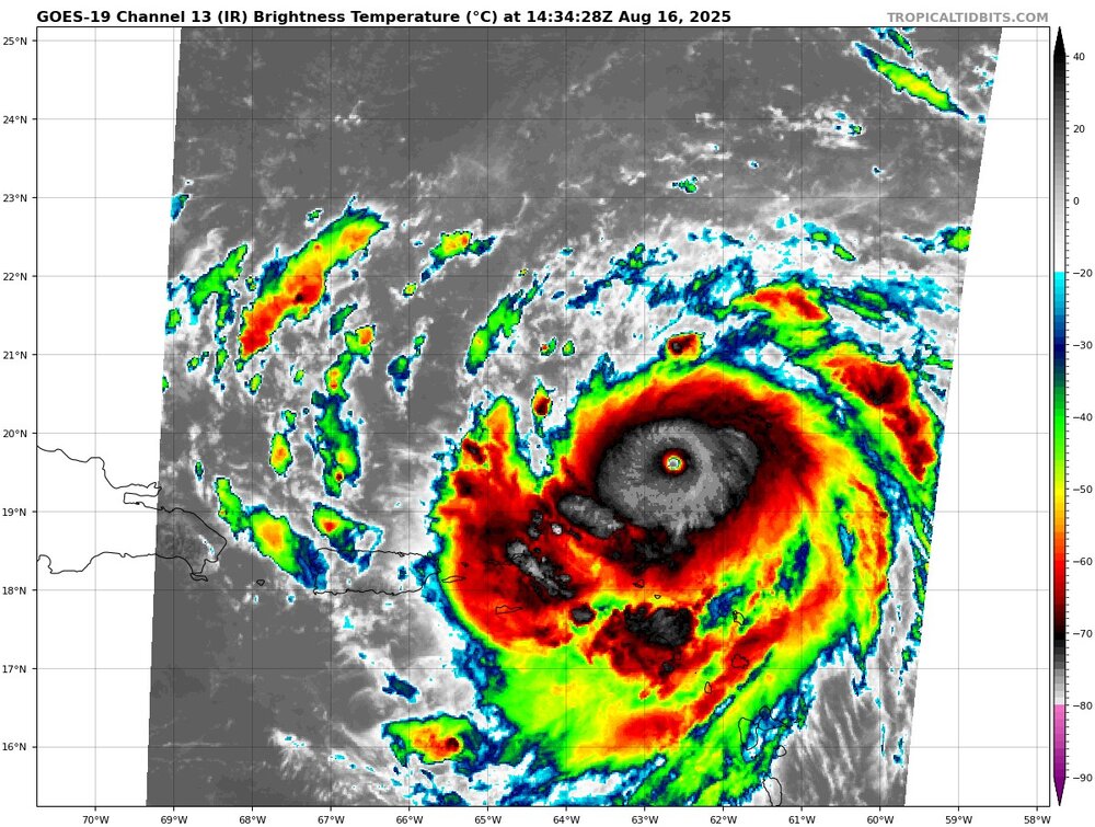
Hurricane Erin - 155 mph - 923mb - W @ 17
Emmett_Brown replied to BarryStantonGBP's topic in Tropical Headquarters
Pressure still dropping, around 916mb on that last pass -
Yeah .5-1.5°C is a nice boost.
-
1. 2024 (161 ACE) didn’t get 2nd major til late Sep. 2. 2023 (146) didn’t have 1st MH til 8/20. 3. 2021 (146) 1st MH 8/20. 4. 2020 (180) 8/26 5. 2019 (132) 8/30 6. 2018 (133) 9/10 7. 2017 (225) 8/25 8. 2016 (141) 8/30 ——— 2025 got 1st MH on 8/16. Seasons with 1st MH by 8/16: 2024, 2008, 2005, 2004, 2000, 1996, 1995…only 7 of last 30 (23%). Edit: We don’t need another storm even near Erin’s incredible strength to end up with an AN ACE season. @snowman19
-
Yeah. We will get another decently warm stretch the end of the month.
-
This will likely start re-curving and gaining more latitude probably in the next several hours. These wobbles and what not are more likely attributed to the rapid organization of the storms structure and strength
-
This is what drives me nuts about Elias. He held off calling him up just for the remote possibility of him appearing on 2 out of the 3 top 100 prospect lists before next year's season and then he goes on to win the rookie of the year award for an extra draft pick at the end of round 1 in 2027. Seems far fetched. He gets more enjoyment out of building an elite farm system rather than having an elite major league roster.
-

Hurricane Erin - 155 mph - 923mb - W @ 17
BarryStantonGBP replied to BarryStantonGBP's topic in Tropical Headquarters
COME ON ERIN WE’RE WATCHING YOU WHILE WE’RE WAITING FOR THE RYANAIR TO FLY US TO IBIZA IT’S HAPPY HOUR IN MANCHESTER AIRPORT SPOONS SHOW US WHAT YOU’VE GOT ERIN Hurricane Erin Satellite | Buoys | Grids | Storm Archive ...CATEGORY 4 ERIN STILL RAPIDLY INTENSIFYING... ...OUTER RAINBANDS AFFECTING THE NORTHERN LEEWARD ISLANDS... 11:00 AM AST Sat Aug 16 Location: 19.7°N 62.8°W Moving: W at 17 mph Min pressure: 923 mb Max sustained: 155 mph Disappointed the nonces over at the NHS didn’t claim cat 5 innit -
Yup just get these storms into favorable shear with no dry air around and they just explode. When you have these storms in waters that normally warm into the 80’s and are still above average…a degree or two at this stage equates to a great deal of energy.
-
And it's already west of all those and still moving due west maybe a little south of west
-
The end of the 6z GFS reaches September 1st. The end is near
-
 It’s a freaking online weather forum. Who gives a shit if a discussion “belongs” in another thread. What a bunch of babies. if you don’t like a post don’t read it. We discuss weather here. Yes even as a believer in climate change some of the posts are excessive, I just don’t read them and scroll on, like an adult.
 -
Most of the Central and W Atlantic are +SST anomalies, it's wild. Erin looks to follow the gulf stream rather nicely too. plenty of OHC to keep going
-
 83 / 68 sunny now
 -
 Is there a way to link a response to something on this thread to the banter thread? I hate responding to non-topic "discussions", and further clogging up the thread, but I can't help myself...
 -
Monday and Tuesday I see weather that would fit in my dreams. Temperature in the upper 70s, overcast, slight east wind. Beautiful Sent from my SM-G970U1 using Tapatalk
-

Hurricane Erin - 155 mph - 923mb - W @ 17
Windspeed replied to BarryStantonGBP's topic in Tropical Headquarters
Ahh, Beven went a little conservative with the pressure and 155 sustained. I don't know if we're going to get another pass. Lamaroni. Edit: No, we are getting one more pass. Score. Erin should not be done deepening. This should be the money pass. -
Mill pond is still empty. https://storymaps.arcgis.com/stories/8e046d3c23494b18a3a154af809965cf
-

Hurricane Erin - 155 mph - 923mb - W @ 17
yoda replied to BarryStantonGBP's topic in Tropical Headquarters
138 WTNT45 KNHC 161433 TCDAT5 Hurricane Erin Discussion Number 21 NWS National Hurricane Center Miami FL AL052025 1100 AM AST Sat Aug 16 2025 Erin has continued to rapidly strengthen during the past 6 h and is now a category 4 hurricane. Reports from Air Force Reserve Hurricane Hunter aircraft indicate that the central pressure has fallen to 925 mb inside a 6 nm wide eye, and flight-level winds in the northern eyewall support surface winds in the 130-135 kt range. The initial intensity is increased to 135 kt, a 70-kt increase since 24 h ago. The aircraft, along with land-based radar data from Sint Maarten, report that an outer eyewall is starting to form. However, this has yet become apparent in the aircraft wind data. The hurricane has been moving a bit to the left of the previous forecast track with the initial motion of 280/15. The track guidance suggests that Erin will turn back to the west-northwest with a decrease in forward speed during the next 6-12 h on the south side of a subtropical ridge. This motion should then continue through the weekend, taking the core of Erin to the north of the eastern Caribbean Islands through Sunday. After 36 h, the western side of the ridge is expected to weaken, due to a series of shortwave troughs moving through the mid-latitude westerlies, and that should cause Erin to slow further and make a gradual turn to the north. The track guidance models are in general agreement with this scenario, but there remain some differences on where, when, and how sharply Erin makes the northward turn. The new track forecast is shifted to the south during the first 12-24 h based on the initial position and motion, and it lies near the southern edge of the guidance envelope. From 24-72 h there track has been shifted westward due to an overall shift in the guidance, and the track is similar to the previous track at 96 and 120 h. The development of the outer eyewall suggests that rapid intensification should end during the next several hours. However, Erin is expected to reach category 5 status before this occurs, and the new intensity forecast now calls for a peak intensity of 145 kt. After 12 h, the environment becomes a little less favorable, with increasing northwesterly shear and possible dry air entrainment. This should lead to gradual weakening of the cyclone through 72 h, although superimposed on this trend will be fluctuations due to eyewall replacement cycles. After 72-96 h, the cyclone is expected to move into the westerlies where the shear is stronger, and a faster weakening trend is expected at that time. The new intensity forecast is at the upper edge of the intensity guidance at 12 h and near the intensity consensus after that. Although Erin is a somewhat compact hurricane now, the models are in strong agreement that the system will grow in size over the next several days. In fact, by the middle of next week, Erin is forecast to at least double or triple in size, which will result in rough ocean conditions over the western Atlantic. KEY MESSAGES: 1. Heavy rainfall at times through Sunday across the northern Leeward Islands, the Virgin Islands, and Puerto Rico may lead to locally considerable flash and urban flooding, along with landslides or mudslides. 2. Gusts to tropical storm force in Erin's outer rainbands are likely in portions of the northern Leeward Islands through tonight and over portions of the Virgin Islands and Puerto Rico later today through Sunday. Tropical-storm force wind gusts are possible in the Turks and Caicos Islands and Southeast Bahamas 3. Erin is expected to produce life-threatening surf and rip currents along the beaches of the Bahamas, much of the east coast of the U.S., and Atlantic Canada next week. 4. Interests in Bermuda should continue to monitor the progress of Erin since there is a risk of strong winds, heavy rainfall, and high surf by the middle part of next week. FORECAST POSITIONS AND MAX WINDS INIT 16/1500Z 19.7N 62.8W 135 KT 155 MPH 12H 17/0000Z 20.1N 64.7W 145 KT 165 MPH 24H 17/1200Z 21.0N 66.8W 140 KT 160 MPH 36H 18/0000Z 22.3N 68.5W 135 KT 155 MPH 48H 18/1200Z 23.5N 69.7W 130 KT 150 MPH 60H 19/0000Z 24.9N 70.4W 125 KT 145 MPH 72H 19/1200Z 26.4N 70.9W 120 KT 140 MPH 96H 20/1200Z 30.6N 70.9W 115 KT 130 MPH 120H 21/1200Z 35.7N 66.4W 95 KT 110 MPH $$ Forecaster Beven -
Yeah. It's interesting how bad the 1880-1900 period was for GA/SC, 1893 and 1898 particularly. Otherwise very rare new gfs rips the potential next system into the gulf, euro recurves similar to Erin.
-
What a beast, cloud tops in the eyewall are still cooling and becoming more symmetrical
-
This neighborhood has had 2-3 strikes just this summer. We sit on ledge which I think attracts lightning . The one in MBY was right before July 4 and another was 5-6 houses down in that wild strobe light overnight MCS