icebreaker5221 Posted August 20, 2012 Share Posted August 20, 2012 The models are all over the place. The GFS drove this disturbance into south Florida. The GGEM is out in the atlantic. How the CMC can get a 960 mb storm after punching it directly through the TUTT and all that dry air is beyond me. But at least the good ole days are back! Link to comment Share on other sites More sharing options...
Ed Lizard Posted August 20, 2012 Share Posted August 20, 2012 How the CMC can get a 960 mb storm after punching it directly through the TUTT and all that dry air is beyond me. But at least the good ole days are back! Better than that, at the end of the run the CMC is taking that Cat 6 storm NNW towards SNE! Link to comment Share on other sites More sharing options...
jconsor Posted August 20, 2012 Share Posted August 20, 2012 Two other recent storms that went over Cuba or Hispaniola and hit s. FL hard: Absolutely. For example, King 1950 bombed out in the short distance between Cuba and FL and hit Miami head-on as a very strong Cat 3 (110 kt). Cleo 1964 took a similar track and also hit Miami directly, probably as a strong Cat 2. Link to comment Share on other sites More sharing options...
HurricaneJosh Posted August 20, 2012 Share Posted August 20, 2012 Two other recent storms that went over Cuba or Hispaniola and hit s. FL hard: Agreed. I didn't include them because I was focusing on extreme-S FL-- to show how even in that tiny bit of space between Cuba and Miami crazy stuff can happen-- but, yeah, Jeanne and Charley are great examples of how passage over the Greater Antilles does not preclude a severe landfall in the USA. Link to comment Share on other sites More sharing options...
Superstorm93 Posted August 20, 2012 Share Posted August 20, 2012 Just add convection! An area of low pressure is located about 1000 miles east of the Lesser Antilles. While satellite imagery and buoy observations indicate that the circulation has become better defined over the past few hours...shower and thunderstorm activity remains limited. Environmental conditions remain conducive for a tropical depression to form during the next day or so as this low moves westward at 20 to 25 mph. This system has a high chance...80 percent...of becoming a tropical cyclone during the next 48 hours. This system could reach the Lesser Antilles by Wednesday and interests in that area should monitor the progress of this disturbance. Link to comment Share on other sites More sharing options...
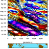
Ed Lizard Posted August 20, 2012 Share Posted August 20, 2012 Using 1000 mb and stronger storms as a discriminator, again it appears OP GFS is somewhat West of most of its ensembles. I am not giving up on a MetFan/NYC forum storm yet. Especially from 7 or 9 days out. Link to comment Share on other sites More sharing options...
PSUBlizzicane2007 Posted August 20, 2012 Share Posted August 20, 2012 Two other recent storms that went over Cuba or Hispaniola and hit s. FL hard: Yup, but to be fair, Jeanne went over the most "friendly" part of Hispañola wrt tropical cyclones while Charley went quickly over a relatively flat area of Cuba. If the core of a storm goes over the central cordillera of Hispañola... it's screwed. Link to comment Share on other sites More sharing options...
HurricaneJosh Posted August 20, 2012 Share Posted August 20, 2012 Yup, but to be fair, Jeanne went over the most "friendly" part of Hispañola wrt tropical cyclones while Charley went quickly over a relatively flat area of Cuba. If the core of a storm goes over the central cordillera of Hispañola... it's screwed. With David 1979 being the classic example of Shredderola's dark powers. That cyclone hit the S coast of Shreddderola as a full-blown, 150-kt Cat 5 and barely exited a hurricane-- and it never really recovered. Gustav 2008 is an interesting example, because it, too, had a very short trek over the W part of Cuba, and yet it was really disrupted. (Granted, it traversed a part of the island that was a little fatter and more mountainous than what Charley encountered... but still.) Link to comment Share on other sites More sharing options...
The Dude Posted August 20, 2012 Share Posted August 20, 2012 Absolutely. For example, King 1950 bombed out in the short distance between Cuba and FL and hit Miami head-on as a very strong Cat 3 (110 kt). Cleo 1964 took a similar track and also hit Miami directly, probably as a strong Cat 2. King doesn't quite fit as it stared in the W. Caribbean and traveled NNE before curving to the NNW. Cleo is a classic example of a storm coming from the E. Caribbean, slipping south of Cuba and Hispaniola and hitting S. Fla. Charley 2004 is the other classic example, albeit with a hit on the west coast of S. Fl. David 1979 comes close, but isn't a perfect fit since it went directly over Hispaniola. Wilma is another example like King 1950 that started in the W. Caribbean, and found it's way to S. Fla, (although unlike King, it carefully adhered to the US's travel embargo of Cuba). Link to comment Share on other sites More sharing options...
Superstorm93 Posted August 20, 2012 Share Posted August 20, 2012 With David 1979 being the classic example of Shredderola's dark powers. That cyclone hit the S coast of Shreddderola as a full-blown, 150-kt Cat 5 and barely exited a hurricane-- and it never really recovered. Gustav 2008 is an interesting example, because it, too, had a very short trek over the W part of Cuba, and yet it was really disrupted. (Granted, it traversed a part of the island that was a little fatter and more mountainous than what Charley encountered... but still.) Gustav also got beat up big time by both indirect and direct interaction with "The Shredder" The only good it did was cause a complete center reformation away from the island, which lead to some steady intensification. This will NOT be a fun thread to follow if 94L takes a trip to the DR or Hati as a weak-ish system. OT: I wish ESRL/EMC kept the old version of the HWRF around. I miss output frames like this. Link to comment Share on other sites More sharing options...
PSUBlizzicane2007 Posted August 20, 2012 Share Posted August 20, 2012 With David 1979 being the classic example of Shredderola's dark powers. That cyclone hit the S coast of Shreddderola as a full-blown, 150-kt Cat 5 and barely exited a hurricane-- and it never really recovered. Gustav 2008 is an interesting example, because it, too, had a very short trek over the W part of Cuba, and yet it was really disrupted. (Granted, it traversed a part of the island that was a little fatter and more mountainous than what Charley encountered... but still.) Yup at David. The cores of those storms just get severely messed up and can't recover. Gustav actually exited Cuba as a category 4. Gustav's problem was mostly shear and dry air if I remember correctly. Ike on the other hand made landfall in a more mountainous eastern part of Cuba while its northern half ran over the length of Cuba.... that messed Ike up severely. Link to comment Share on other sites More sharing options...
EasternUSWX Posted August 20, 2012 Share Posted August 20, 2012 The models are all over the place. The GFS drove this disturbance into south Florida. The GGEM is out in the atlantic. Big shift west from last run Link to comment Share on other sites More sharing options...
HurricaneJosh Posted August 20, 2012 Share Posted August 20, 2012 Gustav actually exited Cuba as a category 4. Gustav's problem was mostly shear and dry air if I remember correctly. Part of the issue with Gustav was definitely the environmental conditions in the Gulf. This having been said, Cuba started the downward spiral: the first best-track fix after Cuba shows it down to 105 kt (Cat 3)-- way below the landfall intensity of 135 kt. Ike on the other hand made landfall in a more mountainous eastern part of Cuba while its northern half ran over the length of Cuba.... that messed Ike up severely. Yep. Ike reminds me a lot of Georges. The core never really rebuilt. Even as it strengthened heading into TX, it remained this big, loose circulation. The pressure was in the low 950s and it just didn't seem to have the have the kick that smaller 'canes with higher perssures (Jova and Ernie) have. Link to comment Share on other sites More sharing options...
PSUBlizzicane2007 Posted August 20, 2012 Share Posted August 20, 2012 Part of the issue with Gustav was definitely the environmental conditions in the Gulf. This having been said, Cuba started the downward spiral: the first best-track fix after Cuba shows it down to 105 kt (Cat 3)-- way below the landfall intensity of 135 kt. Yep. Ike reminds me a lot of Georges. The core never really rebuilt. Even as it strengthened heading into TX, it remained this big, loose circulation. The pressure was in the low 950s and it just didn't seem to have the have the kick that smaller 'canes with higher perssures (Jova and Ernie) have. Georges was amazing simply for the fact that it ran over the entirety of PR, Hispañola, AND eastern Cuba AND survived! It doesn't make sense, and I don't think it ever will. Link to comment Share on other sites More sharing options...
Cheeznado Posted August 20, 2012 Share Posted August 20, 2012 The 12Z GFDL, HWRF and Euro are all very similar at 120 hours to one another. A weak 1003-008 low goes over Hispaniola or very close. There is a pretty good block of evidence that this system will struggle, not even counting whether or not it hits the major islands. The best hope (disregarding the wacky GGEM) is that this stays a wave and maybe sneaks by just south of Hispaniola, but even then it would probably hit Cuba. A lot of hurdles for this one.... Link to comment Share on other sites More sharing options...
HurricaneJosh Posted August 20, 2012 Share Posted August 20, 2012 Georges was amazing simply for the fact that it ran over the entirety of PR, Hispañola, AND eastern Cuba AND survived! It doesn't make sense, and I don't think it ever will. I guess that's the glass-half-full way of looking at it. Link to comment Share on other sites More sharing options...
am19psu Posted August 20, 2012 Share Posted August 20, 2012 I mean, maybe it's right, but this Euro solution continues to be so far out from anything else, I can't buy it. (For those of you with the 6 hourlies, what in the world is it doing between 108 and 126. It's nuts.) Link to comment Share on other sites More sharing options...
Superstorm93 Posted August 20, 2012 Share Posted August 20, 2012 I mean, maybe it's right, but this Euro solution continues to be so far out from anything else, I can't buy it. (For those of you with the 6 hourlies, what in the world is it doing between 108 and 126. It's nuts.) It's really playing out the whole Hispaniola interaction. Decouples whatever center that it would have and continues the low west until it reaches the NW Caribbean. I mean this run weakens it as soon as it enters the Caribbean, but that really hurts it. Link to comment Share on other sites More sharing options...
PSUBlizzicane2007 Posted August 20, 2012 Share Posted August 20, 2012 I mean, maybe it's right, but this Euro solution continues to be so far out from anything else, I can't buy it. (For those of you with the 6 hourlies, what in the world is it doing between 108 and 126. It's nuts.) I don't have the 6 hourlies, but from looking at 120-144, it almost looks as if the Euro is trying to get Hispañola to create some sort of pseudo-lee vorticity or causing it to stretch the vorticity of 94L. Almost similar to how Ivan, for example, went "around" Jamaica due to these sorts of topographical effects, but I'm not sure the Euro is depicting it properly. That's my best guess. Link to comment Share on other sites More sharing options...
am19psu Posted August 20, 2012 Share Posted August 20, 2012 I don't have the 6 hourlies, but from looking at 120-144, it almost looks as if the Euro is trying to get Hispañola to create some sort of pseudo-lee vorticity or causing it to stretch the vorticity of 94L. Almost similar to how Ivan, for example, went "around" Jamaica due to these sorts of topographical effects, but I'm not sure the Euro is depicting it properly. That's my best guess. Nah, it's dissipating the small scale vortex associated with 94L, then reforming a much broader low level center 100 mi farther west with no convection over top. It just doesn't make any sense. Link to comment Share on other sites More sharing options...
CUmet Posted August 20, 2012 Share Posted August 20, 2012 In all honesty, this is probably already a TD or weak TS. Perhaps the convective organization isn't there, but the low-level circulation seems vigorous enough. The ironic thing is that if the storm were more vertically deep, it would probably be taking a further south track and not be in as much risk as skirting the greater Antilles as it is currently shown by the models. The mid-level ridge is actually oriented more ENE/WSW vs. the low-level ridge which is straight E/W. There's definitely a closed circulation looking at the obs from buoy 41041. This is truly on the brink of being classified...probably a few hours of deeper convection will do. Link to comment Share on other sites More sharing options...
CoastalWx Posted August 20, 2012 Share Posted August 20, 2012 I mean, maybe it's right, but this Euro solution continues to be so far out from anything else, I can't buy it. (For those of you with the 6 hourlies, what in the world is it doing between 108 and 126. It's nuts.) Can you see it from a contour of every isobar? It's like a battle for which LLC will win. I like how it jumps NW of Jamaica at hr 150. Link to comment Share on other sites More sharing options...
am19psu Posted August 20, 2012 Share Posted August 20, 2012 Can you see from a contour of every isobar? It's like a battle for which LLC will win. I like how it jumps NW of Jamaica at hr 150. Yeah. It's the lolz Link to comment Share on other sites More sharing options...
Srain Posted August 20, 2012 Share Posted August 20, 2012 HPC: FINAL... ADDED A TROPICAL LOW NEAR SOUTHERN FLORIDA DAY 7 AS PER COORDINATION WITH THE NATIONAL HURRICANE CENTER...THOUGH AT THIS POINT...THE SYMBOL MOSTLY REPRESENTS A POSSIBLE TRACK OF AL94 AMIDST A SEA OF MODEL SPREAD. OTHERWISE...NOTHING IN THE 12Z/20 CYCLE WAS NOTED THAT COMPELLED A SIGNIFICANT CHANGE IN THE MASS FIELD PREFERENCES EXPRESSED IN THE UPDATE PACKAGE. Link to comment Share on other sites More sharing options...
PSUBlizzicane2007 Posted August 20, 2012 Share Posted August 20, 2012 Nah, it's dissipating the small scale vortex associated with 94L, then reforming a much broader low level center 100 mi farther west with no convection over top. It just doesn't make any sense. Well that's weird... and combine that with the jump NW of Jamaica, the Euro solution is seriously bothering me... it's almost as if something has seriously screwed up in the running of the model. Link to comment Share on other sites More sharing options...
CoastalWx Posted August 20, 2012 Share Posted August 20, 2012 Yeah. It's the lolz LIke you said..maybe it's right, but it has some weird things going on. Almost like these weird land interactions at times. Link to comment Share on other sites More sharing options...
HurricaneFrances04 Posted August 20, 2012 Share Posted August 20, 2012 The GFS and EURO really aren't that far apart. Weak system through the Caribbean then a turn north into South Florida as a weak system. I wonder what the ensembles show? Link to comment Share on other sites More sharing options...
MarkSC Posted August 20, 2012 Share Posted August 20, 2012 What the heck is going on with the Euro? First the storm stalls in the Caribbean. Then it jumps west and bombs at hour 240? Link to comment Share on other sites More sharing options...
40/70 Benchmark Posted August 20, 2012 Share Posted August 20, 2012 I guess that's the glass-half-full way of looking at it. Man, did that one frustrate me. Link to comment Share on other sites More sharing options...
Superstorm93 Posted August 20, 2012 Share Posted August 20, 2012 The track on the ECM looks pretty decent, it's just everything else that seems odd. Wouldn't be surprised if the next TWO was a strongly worded one. Some convection is trying to go up near the LLC. Link to comment Share on other sites More sharing options...

Recommended Posts
Archived
This topic is now archived and is closed to further replies.