yoda Posted April 24, 2011 Share Posted April 24, 2011 BULLETIN - EAS ACTIVATION REQUESTED TORNADO WARNING NATIONAL WEATHER SERVICE BALTIMORE MD/WASHINGTON DC 403 PM EDT SUN APR 24 2011 THE NATIONAL WEATHER SERVICE IN STERLING VIRGINIA HAS ISSUED A * TORNADO WARNING FOR... CENTRAL MONTGOMERY COUNTY IN CENTRAL MARYLAND... EAST CENTRAL LOUDOUN COUNTY IN NORTHERN VIRGINIA... * UNTIL 430 PM EDT * AT 402 PM EDT...NATIONAL WEATHER SERVICE DOPPLER RADAR INDICATED A SEVERE THUNDERSTORM CAPABLE OF PRODUCING A TORNADO NEAR LANSDOWNE...MOVING EAST AT 40 MPH. * LOCATIONS IMPACTED INCLUDE... POOLESVILLE... BOYDS... NORTH POTOMAC... GERMANTOWN... GAITHERSBURG... MONTGOMERY VILLAGE... ROCKVILLE... ASPEN HILL... Link to comment Share on other sites More sharing options...
Avdave Posted April 24, 2011 Share Posted April 24, 2011 why not take this to the obs thread, it makes more sense Link to comment Share on other sites More sharing options...
The Dude Posted April 24, 2011 Share Posted April 24, 2011 impressive, but broad rotation Link to comment Share on other sites More sharing options...
Avdave Posted April 24, 2011 Share Posted April 24, 2011 * Tornado Warning for... central Montgomery County in central Maryland... east central Loudoun County in northern Virginia... * until 430 PM EDT * at 402 PM EDT... National Weather Service Doppler radar indicated a severe thunderstorm capable of producing a tornado near Lansdowne... moving east at 40 mph. * Locations impacted include... Poolesville... Boyds... North Potomac... Germantown... Gaithersburg... Montgomery Village... Rockville... Aspen Hill... Link to comment Share on other sites More sharing options...
yoda Posted April 24, 2011 Share Posted April 24, 2011 BULLETIN - EAS ACTIVATION REQUESTED SEVERE THUNDERSTORM WARNING NATIONAL WEATHER SERVICE BALTIMORE MD/WASHINGTON DC 407 PM EDT SUN APR 24 2011 THE NATIONAL WEATHER SERVICE IN STERLING VIRGINIA HAS ISSUED A * SEVERE THUNDERSTORM WARNING FOR... WESTERN HOWARD COUNTY IN CENTRAL MARYLAND... MONTGOMERY COUNTY IN CENTRAL MARYLAND... NORTH CENTRAL PRINCE GEORGES COUNTY IN CENTRAL MARYLAND... EAST CENTRAL LOUDOUN COUNTY IN NORTHERN VIRGINIA... NORTH CENTRAL FAIRFAX COUNTY IN NORTHERN VIRGINIA... * UNTIL 445 PM EDT * AT 403 PM EDT...NATIONAL WEATHER SERVICE DOPPLER RADAR INDICATED A LINE OF SEVERE THUNDERSTORMS CAPABLE OF PRODUCING DAMAGING WINDS IN EXCESS OF 60 MPH. THESE STORMS WERE LOCATED ALONG A LINE EXTENDING FROM 5 MILES WEST OF POOLESVILLE TO COUNTRYSIDE TO ASHBURN...AND MOVING EAST AT 50 MPH. * LOCATIONS IMPACTED INCLUDE... BOYDS... NORTH POTOMAC... ROCKVILLE... POTOMAC... GERMANTOWN... GAITHERSBURG... MONTGOMERY VILLAGE... ASPEN HILL... OLNEY... COLESVILLE... Link to comment Share on other sites More sharing options...
Avdave Posted April 24, 2011 Share Posted April 24, 2011 and just like that it is over, 14 minute storm. Skies are brightning and a comfy 67* now Link to comment Share on other sites More sharing options...
Amped Posted April 24, 2011 Share Posted April 24, 2011 That storms got all the cape to itself. Link to comment Share on other sites More sharing options...
Ian Posted April 24, 2011 Share Posted April 24, 2011 meh Link to comment Share on other sites More sharing options...
LMolineuxLM1 Posted April 24, 2011 Share Posted April 24, 2011 meh Meh is right, lol, that storm down in DC killed robbed anything that could have formed and headed right for me, i am on a thunderstorm drought here everything has been missing me all year so far with just distant stuff, yous down there are so far ahead time for the atmosphere to share. Link to comment Share on other sites More sharing options...
The Dude Posted April 24, 2011 Share Posted April 24, 2011 Meh is right, lol, that storm down in DC killed robbed anything that could have formed and headed right for me, i am on a thunderstorm drought here everything has been missing me all year so far with just distant stuff, yous down there are so far ahead time for the atmosphere to share. Go complain in your own subforum Link to comment Share on other sites More sharing options...
Avdave Posted April 24, 2011 Share Posted April 24, 2011 Meh is right, lol, that storm down in DC killed robbed anything that could have formed and headed right for me, i am on a thunderstorm drought here everything has been missing me all year so far with just distant stuff, yous down there are so far ahead time for the atmosphere to share. Link to comment Share on other sites More sharing options...
Ian Posted April 24, 2011 Share Posted April 24, 2011 cap holding elsewhere so far.. that storm is sucking up lots of juice Link to comment Share on other sites More sharing options...
Ian Posted April 24, 2011 Share Posted April 24, 2011 hmm, thunder.. sunny! Link to comment Share on other sites More sharing options...
bdevil02 Posted April 24, 2011 Share Posted April 24, 2011 Ultimate fringe job. Trying to build a little south, but will probably only do so after it passes DC. Really dark to the north, though. Link to comment Share on other sites More sharing options...
NJHurricane Posted April 24, 2011 Share Posted April 24, 2011 cell looks nasty...baltimore inner harbor water taxi better watch out Link to comment Share on other sites More sharing options...
Ian Posted April 24, 2011 Share Posted April 24, 2011 fringed again? so very fringy Link to comment Share on other sites More sharing options...
Ian Posted April 24, 2011 Share Posted April 24, 2011 whens the bwi groundstop? Link to comment Share on other sites More sharing options...
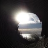
Mrs.J Posted April 24, 2011 Share Posted April 24, 2011 Got to sit and watch the severe storm in Southern Frederick Co. from the second level of my town home. Lightning was amazing and the thunder is still going on. We were just on the Northern edge and was able to get this picture of the back of the storm. Link to comment Share on other sites More sharing options...
nj2va Posted April 24, 2011 Share Posted April 24, 2011 Os/yanks just entered extra innings. Camden yards better watch out. Link to comment Share on other sites More sharing options...
The Dude Posted April 24, 2011 Share Posted April 24, 2011 pea size hail and torrential rain here Link to comment Share on other sites More sharing options...
bdevil02 Posted April 24, 2011 Share Posted April 24, 2011 so very fringy Nice of them to put us partly in the severe area. Link to comment Share on other sites More sharing options...
mitchnick Posted April 24, 2011 Share Posted April 24, 2011 headed right for me I hate these things Link to comment Share on other sites More sharing options...
The Dude Posted April 24, 2011 Share Posted April 24, 2011 blue skies just to my south, but still pouring here. Link to comment Share on other sites More sharing options...
mitchnick Posted April 24, 2011 Share Posted April 24, 2011 meh... http://www.marylandwx.com/tbwi.php Link to comment Share on other sites More sharing options...
lester Posted April 24, 2011 Share Posted April 24, 2011 headed right for me <img src='http://208.71.34.143/public/style_emoticons/<#EMO_DIR#>/sad.gif' class='bbc_emoticon' alt='' />I hate these things Could be worse..at least the circulation weakened lol Sent from my ADR6300 using Tapatalk Link to comment Share on other sites More sharing options...
Ian Posted April 24, 2011 Share Posted April 24, 2011 the little appendage just north of the tip of dc looks a bit more interesting each scan Link to comment Share on other sites More sharing options...
Ian Posted April 24, 2011 Share Posted April 24, 2011 blue skies just to my south, but still pouring here. same here, but the opposite Link to comment Share on other sites More sharing options...
MDstorm Posted April 24, 2011 Share Posted April 24, 2011 Sun breaking out here after 15 minutes of torrential downpours and frequent thunder/lightening. Not much wind,though. MDstorm Link to comment Share on other sites More sharing options...
wxmeddler Posted April 24, 2011 Share Posted April 24, 2011 the southern most cell is going to be dropping hail soon, probably from greenbelt to bowie. Link to comment Share on other sites More sharing options...
mdhokie Posted April 24, 2011 Share Posted April 24, 2011 headed right for me I hate these things The woods around here still look like warzones after last years huge straight line winds came through. I'm done with this severe stuff. Link to comment Share on other sites More sharing options...

Recommended Posts
Archived
This topic is now archived and is closed to further replies.