

WxWatcher007
-
Posts
36,051 -
Joined
-
Last visited
Content Type
Profiles
Blogs
Forums
American Weather
Media Demo
Store
Gallery
Everything posted by WxWatcher007
-

Thursday, July 27, 2023 Severe Weather Potential
WxWatcher007 replied to weatherwiz's topic in New England
-
Thursday, July 27, 2023 Severe Weather Potential
WxWatcher007 replied to weatherwiz's topic in New England
We’re on to Saturday. -
Thursday, July 27, 2023 Severe Weather Potential
WxWatcher007 replied to weatherwiz's topic in New England
Nice line in SE CT -
Thursday, July 27, 2023 Severe Weather Potential
WxWatcher007 replied to weatherwiz's topic in New England
Approaching .75” now haha -
Thursday, July 27, 2023 Severe Weather Potential
WxWatcher007 replied to weatherwiz's topic in New England
Nice rain here post storm. Over .50 today and over 11” for the month. -
Thursday, July 27, 2023 Severe Weather Potential
WxWatcher007 replied to weatherwiz's topic in New England
Pretty, but nothing high end. -
Thursday, July 27, 2023 Severe Weather Potential
WxWatcher007 replied to weatherwiz's topic in New England
Looking NW from Manchester (CT). It’s a beaut. -
Thursday, July 27, 2023 Severe Weather Potential
WxWatcher007 replied to weatherwiz's topic in New England
Looks messy down here aside from that Springfield storm. -
Thursday, July 27, 2023 Severe Weather Potential
WxWatcher007 replied to weatherwiz's topic in New England
Still sunny here. -
Thursday, July 27, 2023 Severe Weather Potential
WxWatcher007 replied to weatherwiz's topic in New England
Watch the area near Salisbury/Canaan. Looks like a hook trying to form with lightning just popping in the past few minutes. -
Thursday, July 27, 2023 Severe Weather Potential
WxWatcher007 replied to weatherwiz's topic in New England
If there's a time for discrete stuff to pop in CT, this is it. -
Thursday, July 27, 2023 Severe Weather Potential
WxWatcher007 replied to weatherwiz's topic in New England
3pm obs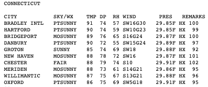
-
Thursday, July 27, 2023 Severe Weather Potential
WxWatcher007 replied to weatherwiz's topic in New England
BULLETIN - EAS ACTIVATION REQUESTED Tornado Warning National Weather Service Gray ME 247 PM EDT Thu Jul 27 2023 The National Weather Service in Gray Maine has issued a * Tornado Warning for... Central Cheshire County in southern New Hampshire... Western Hillsborough County in southern New Hampshire... * Until 315 PM EDT. * At 247 PM EDT, a severe thunderstorm capable of producing a tornado was located over Swanzey, or over Keene, moving east at 45 mph. HAZARD...Tornado. SOURCE...Radar indicated rotation. IMPACT...Flying debris will be dangerous to those caught without shelter. Mobile homes will be damaged or destroyed. Damage to roofs, windows, and vehicles will occur. Tree damage is likely. * This dangerous storm will be near... Jaffrey, Marlborough, Marlborough, Roxbury, Sullivan and Troy around 255 PM EDT. Dublin, Harrisville and Nelson around 300 PM EDT. Hancock around 310 PM EDT. PRECAUTIONARY/PREPAREDNESS ACTIONS... TAKE COVER NOW! Move to a basement or an interior room on the lowest floor of a sturdy building. Avoid windows. If you are outdoors, in a mobile home, or in a vehicle, move to the closest substantial shelter and protect yourself from flying debris. && LAT...LON 4287 7237 4298 7235 4301 7201 4283 7202 TIME...MOT...LOC 1847Z 268DEG 39KT 4293 7227 TORNADO...RADAR INDICATED MAX HAIL SIZE...<.75 IN $$ -
Thursday, July 27, 2023 Severe Weather Potential
WxWatcher007 replied to weatherwiz's topic in New England
Severe thunderstorm warning just issued on that line segment heading into SW Mass and far NW CT. -
Thursday, July 27, 2023 Severe Weather Potential
WxWatcher007 replied to weatherwiz's topic in New England
91/75 at BDL -
Thursday, July 27, 2023 Severe Weather Potential
WxWatcher007 replied to weatherwiz's topic in New England
Agree, timing just seems a little off. We're kind of trying to catch a falling knife. That said, this is the best look we've had for severe all summer so we just roll with it. -
Thursday, July 27, 2023 Severe Weather Potential
WxWatcher007 replied to weatherwiz's topic in New England
3000-3500 SBCAPE, 1500-2000 MLCAPE in CT per mesoanalysis. Should be primed for some good stuff today if you're right. Let's destabilize more. -
Thursday, July 27, 2023 Severe Weather Potential
WxWatcher007 replied to weatherwiz's topic in New England
The thing I worry about today is some pity storm popping, going messy, and stabilizing things for the other convection -
Thursday, July 27, 2023 Severe Weather Potential
WxWatcher007 replied to weatherwiz's topic in New England
Interesting given the two separate MDs, but I suppose the couple tornadoes line covers it. -
Thursday, July 27, 2023 Severe Weather Potential
WxWatcher007 replied to weatherwiz's topic in New England
80 dew in Long Island? I thought we only saw that in the cornfields of Iowa. -
Thursday, July 27, 2023 Severe Weather Potential
WxWatcher007 replied to weatherwiz's topic in New England
Dews gone wild here. New Haven with a HI of 99 at noon lol. -
Thursday, July 27, 2023 Severe Weather Potential
WxWatcher007 replied to weatherwiz's topic in New England
Agree. Another MD issued for the severe part of the threat. -
Thursday, July 27, 2023 Severe Weather Potential
WxWatcher007 replied to weatherwiz's topic in New England
Looking specifically at CT, mesoanalysis is not bad. We have a ribbon of 2500 SBCAPE across the state and between 1000-1500 MLCAPE currently. Lapse rates meh. -
Thursday, July 27, 2023 Severe Weather Potential
WxWatcher007 replied to weatherwiz's topic in New England
-
Thursday, July 27, 2023 Severe Weather Potential
WxWatcher007 replied to weatherwiz's topic in New England
Watch coming per SPC

