

WxWatcher007
-
Posts
36,051 -
Joined
-
Last visited
Content Type
Profiles
Blogs
Forums
American Weather
Media Demo
Store
Gallery
Everything posted by WxWatcher007
-
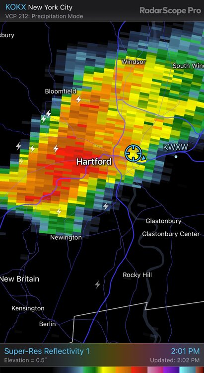
Big strike right by me.
-
A little gusty here but absolutely pouring.
-
I don’t really see it. Looks like a nice drink coming my way though. .48 away from a foot of rain for July.
-

July has arrived ... the Meteorologically defined mid summer month
WxWatcher007 replied to Typhoon Tip's topic in New England
I’m sure they have in the last decade. Some of the seasons pre 2017 were fairly mundane, but we’ve been in an active cycle overall since about 1995. The tear we’ve had 2017 on is legit exceptional. There are reasons to believe this season is at or above average aside from SSTs. I lean the other way but I don’t think their forecast is a hedge. They’ve probably been under forecast the last few years but again an historic run. Also, we’re ahead in NS and ACE so far, but will probably fall behind in ACE unless the central Atlantic produces. -
July has arrived ... the Meteorologically defined mid summer month
WxWatcher007 replied to Typhoon Tip's topic in New England
From a tropical perspective, I like to see that retrograding trough. If this season is going to be anywhere near average the basin needs a quieter period to cut down shear and allow these waves to develop. It looks like that starts happening after the 5th (not including the central Atlantic wave currently). -
I can’t recall a heat wave that was bookended by convection. Back in the day at least, it seemed that heat almost always goes out with a bang.
-
3k NAM looked nice in CT
-
Some around here would meh getting 80 instead of 100 gusts
-
I know but we always say that and then
-
I kind of like tomorrow. Not sure how early convection could screw things up but if we can minimize that the afternoon looks solid for those with reasonable expectations.
-
2023 Mid-Atlantic Severe Wx Thread (General Discussion)
WxWatcher007 replied to Kmlwx's topic in Mid Atlantic
The underrated days produce. Glad everyone is ok. -
July has arrived ... the Meteorologically defined mid summer month
WxWatcher007 replied to Typhoon Tip's topic in New England
What a storm that was. -
Thursday, July 27, 2023 Severe Weather Potential
WxWatcher007 replied to weatherwiz's topic in New England
Yeah I should have noted that prior to this recent 5 year period in CT, I lived in DC. Winters have been unpleasant to say the least for me. -
2023 Atlantic Hurricane season
WxWatcher007 replied to Stormchaserchuck1's topic in Tropical Headquarters
I kind of like the idea of two NS next week @GaWx EPS hints at it. -
EPS today likes the idea of two possible named storms. One offshore (see above) and one in the central Atlantic.
-
July has arrived ... the Meteorologically defined mid summer month
WxWatcher007 replied to Typhoon Tip's topic in New England
Yes. A thousand times yes. How do I know? My wife. -
Thursday, July 27, 2023 Severe Weather Potential
WxWatcher007 replied to weatherwiz's topic in New England
That’s how bad the last decade has been. You taint while it’s 50° rain here lol. -
July has arrived ... the Meteorologically defined mid summer month
WxWatcher007 replied to Typhoon Tip's topic in New England
This. The dews have been notable, the temps have not. -
Thursday, July 27, 2023 Severe Weather Potential
WxWatcher007 replied to weatherwiz's topic in New England
Must be nice not worrying about taint Its a great climate here in New England. Plenty of variety, including quiet and nice periods. -
Thursday, July 27, 2023 Severe Weather Potential
WxWatcher007 replied to weatherwiz's topic in New England
Isn’t it relative though? We’re not built to have derechos with cat 2 winds like Iowa or giant hail like Texas. We can’t get cat 5s like Florida or heat like Phoenix or cold like Minnesota. Hell we barely do region wide KUs now. Our climate has versatility—we can do a lot of things if the stars align, but I’m not sure we can do anything particularly high end frequently like other regions. -
July has arrived ... the Meteorologically defined mid summer month
WxWatcher007 replied to Typhoon Tip's topic in New England
Yeah the heat (air temp) has underwhelmed so far. Heat indices were the real deal here yesterday with upper 70s dews. -
Too close to land to do anything but it may have a chance to develop as it gets swept out to sea by the coming trough that’ll also sweep the central Atlantic wave away.
-
Thursday, July 27, 2023 Severe Weather Potential
WxWatcher007 replied to weatherwiz's topic in New England
It’s an imby game. Always. And weenies (myself included) have trouble separating the fantasy from reality. We could literally have a category 5 hurricane run straight through New England and we’ll have folks call it a bust as its track shifts up the coast with trochoidal motions, meh it as an outer rain band misses their house, shrug it off as a non-event if their house receives minor damage, and downplay it if the highest recorded gust was “only” 140 mph rather than the 165 gusts the NHC had in the advisory before landfall. It’s just what we do. -
Thursday, July 27, 2023 Severe Weather Potential
WxWatcher007 replied to weatherwiz's topic in New England
I'm not sure what the expectations were? I think this did ok south of pike. Other than the tor in NH it underperformed there. -
Thursday, July 27, 2023 Severe Weather Potential
WxWatcher007 replied to weatherwiz's topic in New England
From a friend earlier:- 535 replies
-
- 14
-


