Typhoon Tip
-
Posts
43,363 -
Joined
-
Last visited
Content Type
Profiles
Blogs
Forums
American Weather
Media Demo
Store
Gallery
Everything posted by Typhoon Tip
-
welp ...now that winter's come and gone ... we turn the page into spring starting tomorrow. annnd as usual around here, we only get spring for one afternoon before the heat of summer bullies in. oh wait - actually, i'm rather impressed that there's no back dooring from sunday to next tue/wed. you can kind of see a paltry attempt to buckle/confluent the flow a little over ontario, but it the total mechanics are too longitudinal so it ends up just being a weaker air mass change. we'll see. but that's a nice extended period of out doorsy days persisting in the guidance - it's impressive how long this has been a stable look in the models.
-
last night was a classic radiational cold manufacturing, and yes ...it favors lower elevations. it probably floored somewhere 35 to 40 along any ridge or hill elevation that is adjacent to a cold air drainage sloping down to dales and nadirs in elevation. if you get out in the middle of plateau-like region, farther removed from a gravity well than there was probably a shallow decoupled pool of 32ies ... but by and large, these mornings don't freeze 10 year old tongues to flag poles around 1,000 feet. the preceding is a description designed specifically for Raymond -
-
i think "28 freeze" must be a rough or average because it froze here at 29. no question. it was 34 by midnight, and we were car-topped and glistening by 10. the graphs at the local sites all indicated several hours below 32 - it seems if we're spending multiple hours at 29 it's getting the job done. heh, morning nit pick
-
29 ..we were softly kissed by a frost two nights ago when we pinged 34 and a half for a low, but this morning is for real. Cold enough to even observed that still air cold shock leaf fall, a phenomenon owing to expansion of phase change in leaf stems fracturing - assuming so. usually kicks in around 30. i've seen late trees offload almost half their previous afternoon color in a single morning down to 19 before. it's a neat albeit nerdy observation i like to look for every autumn
-
lol buuut... gotta give Kevin the nod on that one. he did not say "80s" ... nor days and days of it? pretty sure he say a couple days of 80 given that spread there and well .. meteorology of that synopsis, 80 would be possible. reminder, it was 80 to 82 for 3 or 4 days in november of 2020 in the interior
-
and what's up with the 2-meter t's this weekend on guidance. ggem's frosting the interior dales under 590 dm heights. i figure for higher end diurnal ranges, sure but how wide -
-
i was surprised i didn't frost last night .. we stopped at 39. noticed some breeze at dawn so that's probably why - lack of decoupling. may not be an issue tonight.
-
that comparison is unfortunately less then any usefulness. we can't compare disparate regions if/when the accumulated data is non-comparable time spans. the bigger picture: also, having occurred at two different ends of a cc curve, one proving to be a non-linear response, i.e. accelerated(ing), immediately invalidates. ...but maybe that was sarcastic..
-
yeah, agreed, it's true re the marginal effect. however, once any objective reality outside just that region of urban expansion is very necessarily included ( much less even considered...) the argument is immediately rendered entirely false. op ed: 'climate change non-conforming' philosophy usage/narratives appear to be less clear on a fundamental aspect of nature: non-linearity of complex systems. these cncp debate artists, they only see (X + X + X) as = 3x ... but in fact, nature never works that way. it always equals 3x' ( prime ) .... a differential of some unintended and/or synergistic reductions, or gains, either way. nature is messy. not pointing anyone out in this social media ... i haven't gone back and looked over any posts or exactly attempted to apply a Myers-Briggs assessment to gather truer intent, either... ha simply put, the atmospheric chemical make up, inside vs outside any city 'expansion', is no different after the fact of AGHG homogeneity ... it's a matter of comparing deltas, d(rural temperature) = a smaller gain than d(city temperatures). lost on most people... the rest could 'get it' if they wanted, but carry on with some other morality influencing an agenda.
-
big fan of older/traditional physical settings in the observations of weather.. still have not seen any virga shrouded cu despite these chillier days. need to see that first -
-
i'm waiting on the models to add 1.5 to even 2c at 850 in that look. i've noticed that warm signals are muted in that 850 mb metric in long ranges, just as much as cold signals tend to correct as having been too deep - however much, either case, notwithstanding. we saw 81 at ash and bed and fit back during that warm spell, nov 5-10, 2020 from a pattern similar to this look. just sayn'
-
more of an extended range forecast post above than an enso topic but yeah. heh. i would also add that wave lengths are in seasonal flux ... that aleu anomaly, once faster foot velocities are installed and the rossby wave numbers reduce, that's not likely to be there. or if so ...it's likelier that the winter paradigm happened to end up doing the same thing thru a different wave number. just sayn' in a nut shell that's probably partial in why octobers bear so little statistical value wrt ensuing winters frankly ... i think we're seeing a dominant +annular mode this winter, regardless ... and, doing so in this particular era of the 'hockey stick' cc explosive rise ... it's like trying to sniff out a winter fragrance in a room full o digshit.
-
yeah ... climate infers the dimming should be happening, anyway - we'll see.
-
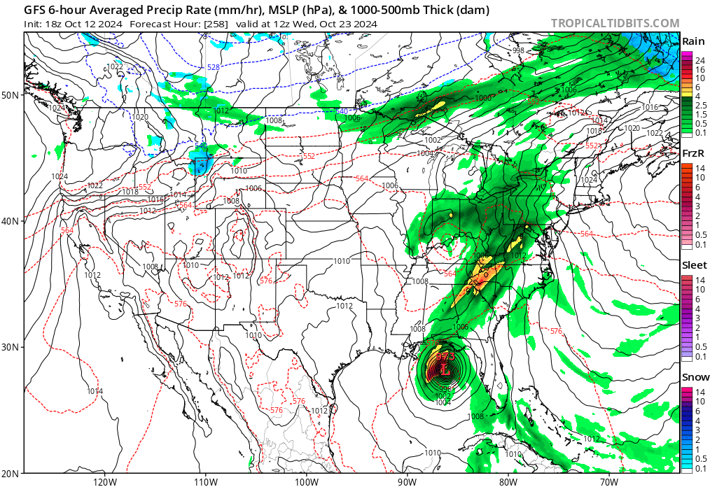
while not at the scale of precedence discussed in this thread to date ... the warm up spanning the n ov to ne and n ma region from late friday thru early this next week has some potential to be historic. we've been monitoring a robust +500 mb anomaly in both the individual operation versions, all of which is very well statistically anchored by the teleconnector modes/modalities during the period. the particulars/dailies have the ambient polar boundary anomalously situated n of seasonality, with a very large circumvallate of 850 mb temperatures above +12c through said region, under the influence of dvm/associated higher surface pressure. well established deep layer west wind transports w ejected mass spanning a minimum of 3 days - may only be 2 day but given to what is also non-deviated continuity for this signal in the above spectrum of guidance., it may take us into early next week. the sun is feeble(r) - that is apparently the only limiting factor. can it dump enough energy into the described environment to max the potential. probably not I'd say...but given to 80 or so % of what that is, would still make these records below vulnerable. note, in 2020 we achieved 79 to 83 at sites in the interior of sne as late as november 9. i was looking around at records for oct 18 and 19. hartford ct part of this is a bit experimental. we are observing 'over achieving' warmth just about whenever a pattern is conducive to positive anomalies, world over... relative to climo and/or predictive methods ( machine and experience or both). this look in the 500 mb/ 850 thermal layout/ synoptic tapestry is a 'smoking gun' for testing that again... October 18 84 2016 October 19 82 1963 October 20 81 1969 both new york and boston are similar
-
not trying to troll the interest in the near term cold shot - it's impressive. but i really ( personally ...) think that focus is eclipsing a potentially bigger story.. 2 facets: - scalar achievement in warm anomaly - the delta between tue-thur and the weekend in itself both these records have an outside shot of being reset this sat and sun at hartford, ct October 19 82 1963 October 20 81 1969
-
heh ... not going to say they are wrong out of hand - haven't read their afd philosophy but in so far as the veneer of this graphic above i'm not sure i agree with that assessment
-
that 500 mb evolution in the operational version blend for this weekend is drawn out of a july playbook for heat waves. it's been on the charts much more than less for many day's worth of runs at this point, and it also fits into the ens mean/derived telecon spread. we saw 80 as late as nov 9 in 2020. we're 3 to 3.5 weeks up hill in solar so it's interesting if we can get that or even a couple of 85ers. the metrics are ideal, otherwise. near nil ceiling rh, west wind conveyor toting 850s 14+C . one should assume they'll be slightly higher than 13 when/if the overall impression is taking place.. impressive anomaly for this time of year when 500 mb non hydrostats over 588 dm ... the only limiting factor is whether the steepening angle of the sun can dump enough energy into that environment - if so... what are the records for that period, sat and sun? if one is a warm weather enthusiast ... just bear it for a couple days in the near term. the synoptic wind may still be active tomorrow night but with these longish nocturnal ... anywhere that does manage to decouple may drop below the 2-meter 37s
-
i don't think, or am not sure is probably better, that the pdo is causal? i may have even read this ...but the pdo is largely a result of aggregated ss stressing from wind patterns over some length of time. so the warm or cool phases are distributive based on atmospheric-oceanic coupling, really. in other words, the pdo is best describing where the momentum has been distributed. then people see these graphical products with pretty red or blue respectively ...and they go 'aha!' red must make a ridge, then blue must make a trough. it could in fact be these latter that formulate the former. haha but here's the thing - the sensitivity in defining the pdo cool and warm phases may also be sensitive below the threshold of atmospheric forcing anyway. not sure how how a +.5 or a -.5 oceanic surface anomaly is a silver bullet to why chicago to washington has a cold or hot winter. etc i could see maybe some sort of feedback at little... but what's the threshold? is 1 deg c of sst anomaly enough ? ... .5 ... ? or is it 2, otherwise it's all bullshit.
-
can you imagine what a genius one would look like then if they'd forecast this recent -aug that just happened in boston lol come to think about it, the stunningly 'hot' +0.3 that location put up for the next month, sep, is probably equally as difficult during this era of cc, too. so may as well take the two months together. (-0.7 + +0.3)/2 = -0.2 for the two together i'm only mentioning because i've noticed recurrence of a se can/ne us cool pool, which seems to be quasi reproducible. i know why, or strongly suspect the reasons but tl;dr just one quick thought.. if se can/ne us was in a relative temperature hole, then naturally ...we look around for a comparable hill - but there's a problem. whenever we do, the hills are more like mountains, where's the valleys that are supposed to couple and make for a general neutral total ... don't. i mean look what happened in phx and other areas of the sw/california while boston limped to a 2-month average of -0.2 ? we are not balancing the landscape. there's like a cool air drainage basin here. look at canadian sep - warmest sep like ever... while boston limps. not the first time i've seen this synoptic dumpster over se can/ne us there's a bit of a perhaps sociological perspective that bugs me in this.. eastern n/a's mid latitudes are being enabled by the geometric base line perennial pattern - which features elevated heights west, with a flattening ( or subtle trough) in the east. that is creating the cool pool tendency - tendency not meaning it is always there... and as such, the region is toned in "red" on the ipcc reports and whatever reports in the compendium. but this back-o-ball-bag heat is having more to overcome in order to manifest. so is comparatively rarer. it seems more and more so when i look around, these 'perennial hills' around the world are where the heat bombs are going off, where the canonical valleys are experiencing warming ... but since they lack specific synergistic events the sensible realization is a more tepid cc response in those regions. it's all a perfect layout to hide cc from one of the very densest population of fossil fuel dependencies, one that could really use the smack in the face wake up call. haha
-
and the it could be cooling degree days after that
-
"At this point, though, Schmidt says, none of these developments — or even a combination of all of them — seems sufficient to explain the heat. This, in turn, raises several other possibilities. The recent temperature run-up could be the result of some development that’s yet to be identified. Or it could mean the climate system is more unpredictable than was thought. Alternatively, it could indicate that something is missing from climate models, or that amplifying feedbacks are kicking in sooner than the models had predicted. .." again, the 'reason' they are missing is synergy. these philosophers keep trying to find it in some kind of polynomial summation, if not a silver bullet. they're unlikely to find it there it's going to be found in the synergistic realm - which cannot be defined in those linear contributors. it only exists when the linear variables are working together in harmonic feed backs. just as any dictionary would define, it's an interaction or cooperating parts that give rise to a whole that is greater than the simpler sum of its parts. sorry folks, but when you deal in dynamics, 2+2 really = 5 they can't just combine variables. i don't believe that temperature surge could be derived any other way - it's a 'smoking gun' ( puns intended to annoy ... ) for a synergism - and ... a warning. probably above all, why humanity, despite all conceits ... is dumb fucked in trouble for tinkering like they are a Kardashev 1 civilization. as an aside, when they can't even stop famine, disease, and their own creative inequality; how are they going to be responsible for their own innovation? enter Fermian Paradox explanation -
-
70 here ... you guys are talking 50s up there? it's interesting how weak the actual caa terms must be. like the flow is parallel to thickness gradient. nevertheless... once the ceiling arrives and 'caps' the chilly air and then starts raining into this 'thermodynamic' cold air mass... that's the first real nasty look of the autumn. talking 50s and wet ~ 100 miles either side of line from alb-bos. yuck. and yes, the seemingly perfunctory october snow chance has arrived - it's part of the new climate signal ...leave it at that, which has been recurring often enough to raise eyebrows. it's just situated a little n of 40 n this time, but here we are again ... mid october with a d-drip. then, anyone noticing that that warm signal next weekend? wow. if anything, the 850 mb metric is probably underdone at this range/given to the 500 mb isohypses evolution. that's an impressire -pnap continent. 590 dm hghts to almost alb in the gfs is impressive, particularly when it's not merely there for just a day. we'll see ... still a couple days to mess it up before it gets more confident, but the fact that the pna index is hugely correcting from +1 all the way -1, while the ao/nao are switching positive.. yeah
-
i don't see any major issues with his interpretation, which as delivered is blend of teleconnector understanding ... combined with daily mass field migrations - he's not clear if the latter is ensemble/blend or operational model version ( ggem, euro, gfs ) and that blend. but in so far as what he has said, there's really only one nit pick that i can see. it's this statement ( bold ) below: "This general predicted pattern across North America is troughing/negative geopotential height anomalies in the Gulf of Alaska forcing ridging/positive geopotential height anomalies across the interior of North America. This pattern favors widespread normal to above normal across much of Canda and the United States (US) with normal to below normal temperatures limited to Southeastern Canada and the US East Coast. " i can see a pathway to where he would be correct, but i don't see a means to determine the probability therein, to say 'favors' one way or the other. it has to do with the abstraction of the time of year/climatology of geometric wave dispersal across the hemisphere. ..say that fast.. i just mean that the wave lengths are still not really in the winter 'stretch' mode, to where teleconnectors are in their highest pattern correlative value. in the nebular heights of summer .. a +pna does not nearly mean the same spatial resolution as it does in gradient saturated l/w anchored nadir of late January and so on.. such that with shortened wave lengths there's time/space to buckle and well ...we've been seeing this tucking/folder over trough repeating since mid september - sort of 'cheating' us into thinking season's canonically behaved, when we're really just created a cold puddle hole in an otherwise toasty hemisphere ( relative to climate ). that said, the -EPO onset with correlated -PNA undergirding, favors a height drop over 110+ w across the mid lat continent. that couples with rising heights ( again ... in the canonical sense ) over eastern mid latitudes. but again, that doesn't mean we can't 'tuck' - it's not clear that he's thinking about that nuanced occurrence or not. frankly, if it were up to me and my druthers... we'd balm the f out until thanks giggedy
-
Gobblin green glow during this pulse so far